Clear Sky Science · en
A measurement-driven cross-sectional method to assess the dynamics and flux of dust transport
Why Dust Storms Matter to All of Us
Dust storms may sound like distant desert problems, but the fine particles they lift can travel thousands of kilometers, darken skies over big cities, and seep deep into our lungs. This paper follows an unusually powerful dust storm that started in northern China and swept all the way to the humid south in April 2025. Using advanced instruments that look upward through the atmosphere, the researchers tracked how much dust was carried, how high it traveled, and how the storm’s winds pushed it across the country. Their findings help explain how far‑away deserts can suddenly turn the air dangerous to breathe in places that normally feel sheltered from such events.
Following a Giant Cloud of Dust
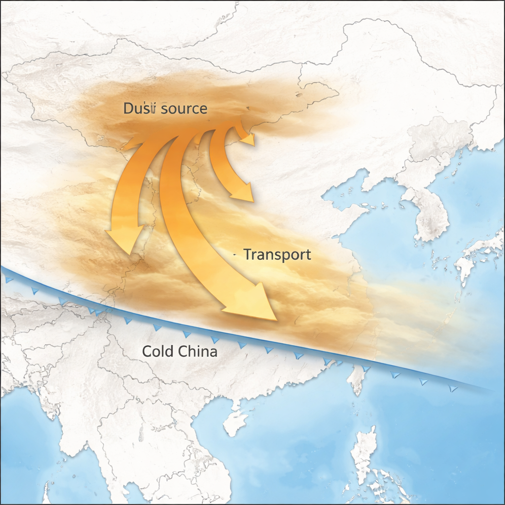
The story begins in Inner Mongolia, on the edge of the Gobi Desert. In April 2025, an unusually strong spring cold front built up over northern China, bringing powerful northwesterly winds. Satellite data showed a sharp jump in a special “aerosol index” that reveals the presence of sunlight‑absorbing particles, confirming that large quantities of dust were lifted from the dry ground. In the city of Wuhai, near the dust source, coarse particle levels (PM10) soared to more than 800 micrograms per cubic meter, with the true peak likely above 1,000. As the cold front slid south, it acted like a conveyor belt, pushing this massive dust plume toward central and southern China.
When the Desert Reaches a Southern Megacity
By April 13, the dust front had reached Guangzhou, a heavily populated hub in southern China where such intense dust episodes are rare. There, ground measurements showed PM10 climbing from a typical 32 micrograms per cubic meter to peaks above 400—several times higher than during any dust event in the previous decade. At the height of the storm that afternoon, more than 90 percent of the airborne particles were dust rather than local urban pollution. This sudden spike turned a normally humid, coastal city into an air‑quality hotspot more reminiscent of the desert interior, illustrating how extreme weather patterns can spread health risks far beyond traditional dust belts.
Looking Up: Dust Layers Above the City
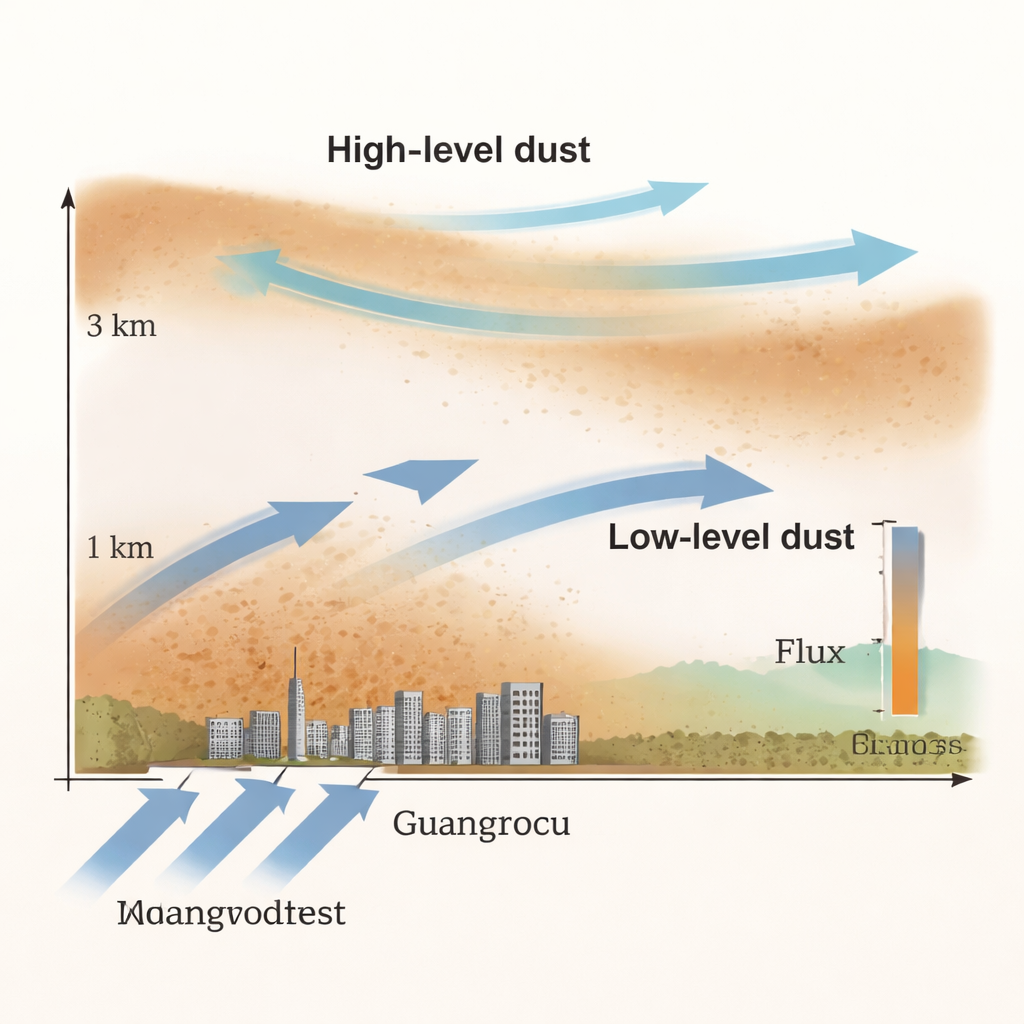
Most pollution measurements focus on ground level, but this study looked upward through several kilometers of air. The team combined a “wind radar,” which shows how air moves with height, with a laser‑based “particle lidar” that detects dust by how it scatters and polarizes light. They found that during the first phase of the event, called the lower‑level transport period, almost all of the dust traveled below about 1.5 kilometers, with extremely high concentrations close to the surface. Later, in a higher‑level transport period, the winds near the ground weakened while stronger northerly winds blew aloft. Dust then formed an elevated layer reaching up to 3 kilometers, even as near‑surface levels slowly declined. By comparing wind speed and dust concentration at each height, the researchers calculated how much dust mass passed overhead per hour.
Weighing a Moving Cloud Across a Continent
To move from a single observation site to the bigger picture, the team developed what they call a measurement‑driven cross‑sectional method. First, they estimated how much dust crossed a one‑kilometer‑wide vertical slice of air above Guangzhou every hour, correcting for the share of particles that came from city emissions rather than desert sources. Then, using ground data from over a hundred monitoring stations spread across southern China, they found that dust concentrations along a west–east line could be described by a bell‑shaped curve. This allowed them to scale up the flux at Guangzhou to the entire region. Their calculations show that at the peak of the storm, about 11,200 tons of dust per hour were flowing southward across 23°N latitude, and that roughly 248,000 tons of desert dust were transported into southern China over the full event.
What This Means for Our Future
The study concludes that an unusual combination of a strong spring cold front and very dry conditions in the Gobi Desert enabled a rare, extremely intense southward dust transport event. Beyond documenting a single storm, the work demonstrates a practical way to “weigh” moving clouds of particles in three dimensions, not just at ground level. As climate change lengthens dry seasons and alters wind patterns, such tools will be vital for forecasting when and where dust will strike, planning health warnings, and understanding how dust interacts with other pollutants and climate‑warming gases. In simple terms, this research shows how to turn a murky dust cloud into clear numbers that can guide better protection of people and the environment.
Citation: Lin, C., Deng, X., Yao, T. et al. A measurement-driven cross-sectional method to assess the dynamics and flux of dust transport. npj Nat. Hazards 3, 5 (2026). https://doi.org/10.1038/s44304-026-00166-y
Keywords: dust storms, air pollution, long-range transport, climate change, China