Clear Sky Science · en
Mapping and revealing the tree biodiversity of the Brazilian Cerrado through biome-wide sampling efforts
Why This Hidden Savanna Matters
The Brazilian Cerrado is often overshadowed by the Amazon, yet it is the most plant‑rich savanna on Earth and a crucial source of water for South America. At the same time, nearly half of its natural vegetation has already been cleared for farms and ranches. This study delivers the first detailed, biome‑wide map of tree diversity across the Cerrado, revealing where tree species are most concentrated, what environmental conditions support them, and how human pressures such as fire and land conversion are reshaping this vast landscape. 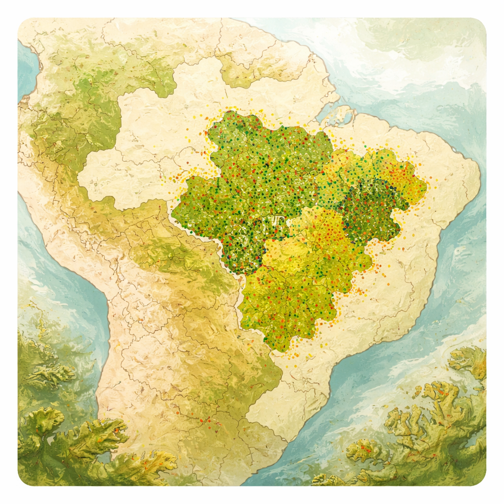
Taking a Census of Trees Across a Giant Landscape
To understand how tree life is distributed in such a huge region, researchers drew on Brazil’s National Forest Inventory, a coordinated effort that placed hundreds of standardized sampling plots across the country. In the Cerrado, they measured and identified all woody plants above a set trunk size in more than a thousand plots spread over savannas, woodlands and forests. This allowed the team to compare local tree richness—how many species are found in a given hectare—as well as how evenly those trees are distributed among species. By using a statistical method called LOESS, the authors then transformed those scattered plot measurements into continuous maps, predicting tree richness at a grid of roughly 11‑kilometer squares across the whole biome.
Where Tree Life Is Richest—and Where It Fades
The resulting maps show that Cerrado tree diversity is far from uniform. The highest richness occurs in the central and southwestern parts of the biome, especially in woodland savannas, dry forests and riparian (river‑side) forests, which act as islands of dense, moist habitat in a broader grassy matrix. These areas can host around 50 or more tree species per hectare. In contrast, the more open, frequently burned savannas known as cerrado sensu stricto, as well as palm‑dominated formations, tend to have fewer tree species and lower tree density. Northern and northeastern fringe regions, closer to the drier Caatinga biome, show notably lower richness, suggesting that both climate and geography create a gradient from rich central zones to poorer edges.
Climate, Soils and Fire Shape the Tree Mosaic
To move beyond simple mapping, the authors tested which environmental factors best explain these patterns. Areas with more rainfall and a broader annual temperature range tended to support more tree species, highlighting the importance of water and energy for sustaining diverse plant communities. Certain soil traits also mattered: looser, clay‑rich soils with lower aluminium levels were linked to higher richness, likely because they hold more water and nutrients and are less chemically stressful for roots. By contrast, frequent fire strongly reduced tree richness. Although fire is a natural part of the Cerrado, repeated burning—often driven by human land use—favours a small set of hardy species and prevents many others from establishing, gradually lowering local diversity. 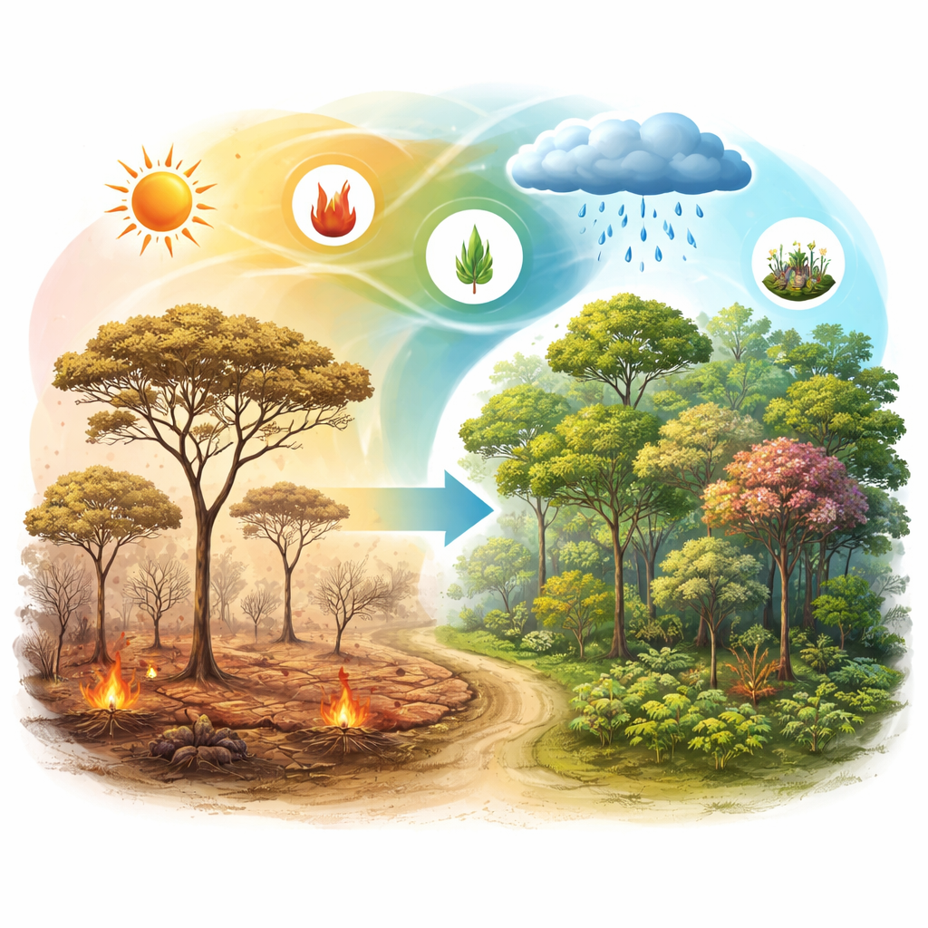
Implications for Conservation and Future Change
These findings arrive at a critical moment, as deforestation in the Cerrado has recently outpaced that in the Amazon, and hundreds of tree species may be pushed toward extinction if habitat loss continues. The study shows that not all parts of the biome contribute equally to its botanical wealth: central and southwestern transition zones, especially where Cerrado blends into Amazonian forests, are key hotspots. At the same time, the clear influence of rainfall, temperature, soil conditions and fire means that climate change and land‑management decisions could rapidly alter where trees can persist. Managing fire carefully, protecting areas with favourable soils and moisture, and expanding strictly protected areas in the richest districts emerge as practical routes to safeguard this unique savanna.
What It All Means for Non‑Specialists
In simple terms, the researchers have produced a high‑resolution “heat map” of where tree species are most abundant across the Cerrado and identified the main levers that keep this diversity high: enough rain, moderate temperatures, good soils and limited fire. Their work turns scattered field plots into a coherent picture that policymakers can use to decide where new reserves, restoration projects or fire regulations will have the greatest impact. For anyone concerned with food security, climate stability and freshwater supply, the message is clear: protecting the tree diversity of the Cerrado is not just about saving rare plants—it is about maintaining the living backbone of a biome that underpins human well‑being far beyond Brazil’s borders.
Citation: Giles, A.L., Faria, L.D.B., Souza, H.J.d. et al. Mapping and revealing the tree biodiversity of the Brazilian Cerrado through biome-wide sampling efforts. npj biodivers 5, 9 (2026). https://doi.org/10.1038/s44185-026-00122-z
Keywords: Cerrado, tree diversity, savanna, biodiversity mapping, fire and climate