Clear Sky Science · en
Unraveling Sundarbans’ erosion: how machine learning maps climate change impacts
Why this delta matters to all of us
The Sundarbans, the world’s largest mangrove forest at the mouth of the Ganges, is a natural shield for millions of people against storms and rising seas. Yet its maze of islands is steadily reshaped as coastlines crumble in some places and grow in others. This study uses decades of satellite images and modern computer tools to untangle how and where the Sundarbans is changing, and when simple methods are enough versus when more advanced machine learning is needed. The answers matter for protecting both coastal communities and this globally important ecosystem.
A shifting maze of islands
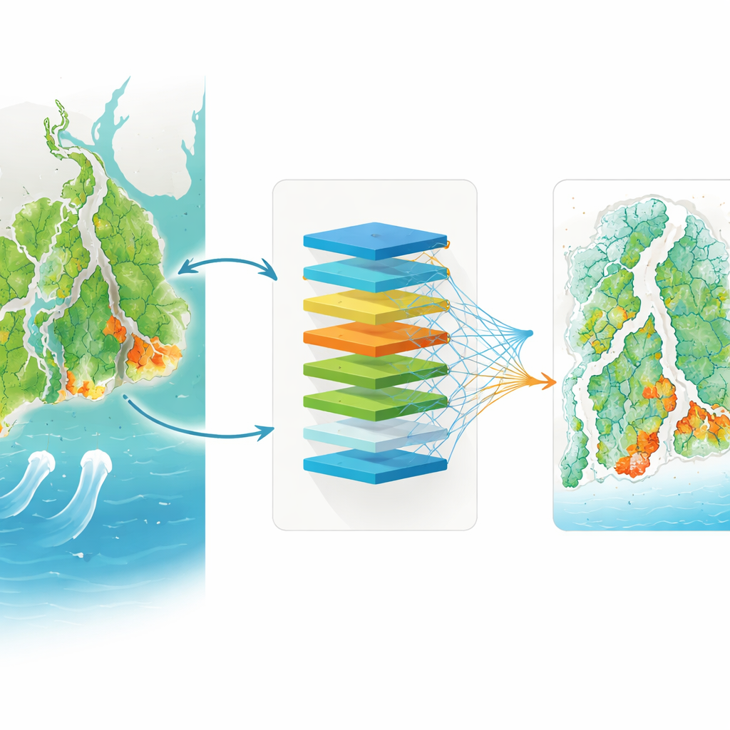
The Sundarbans Biosphere Reserve in India contains nearly a hundred forested islands, laced with tidal channels and fringed by mangroves. Although human pressure is relatively low inside the reserve, the region has already lost around 100 square kilometers of land over the past three decades, mainly along the open southern shores. By tracing the shoreline at thousands of evenly spaced points from 1988 to 2023 using satellite images, the authors built a detailed picture of which coasts are retreating and which are growing. They found that the southern, sea‑facing islands are eroding rapidly, in some spots by more than 30 to 50 meters per year, while parts of the western and far northern islands are gaining land through new sediment deposits.
Reading straight lines in a restless coast
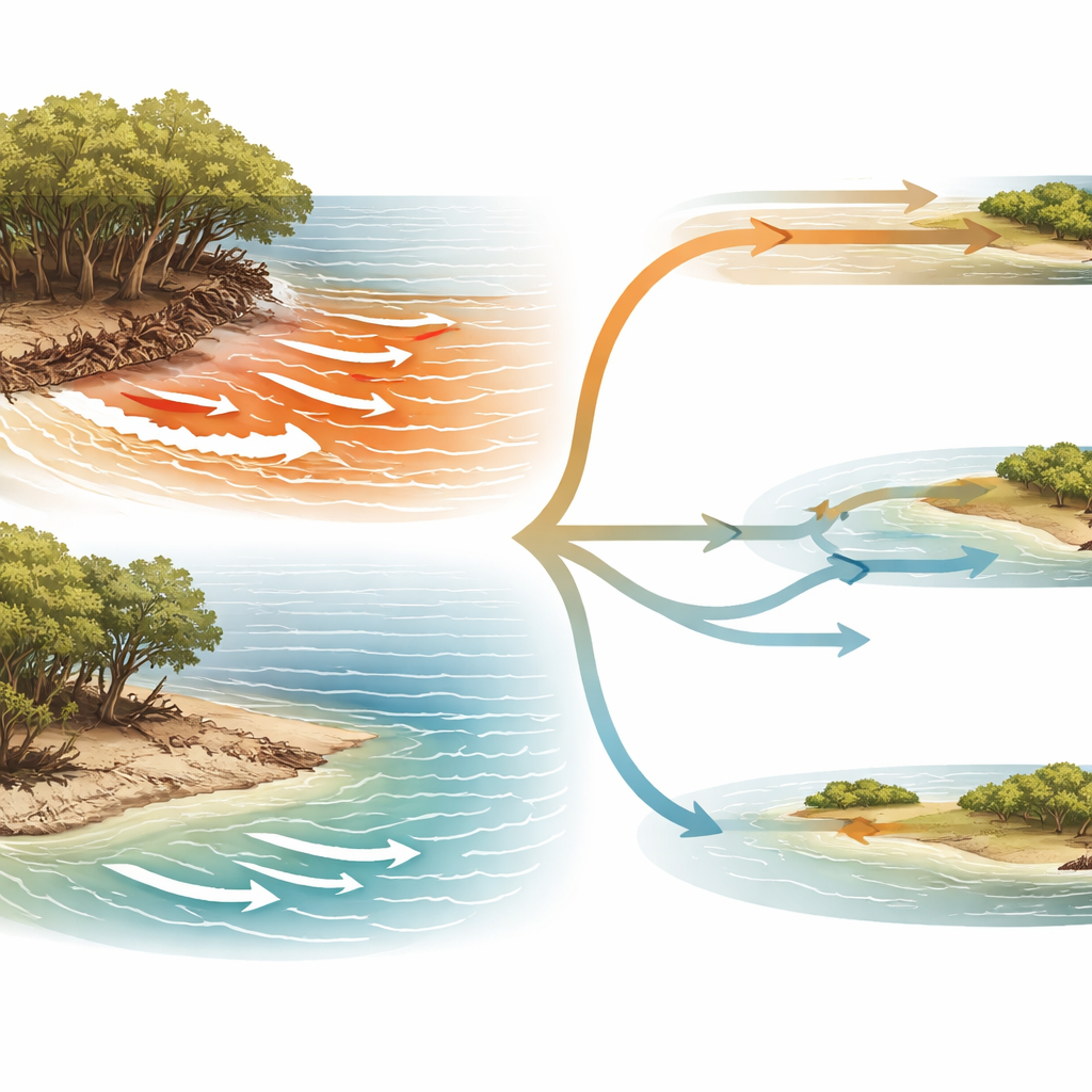
To describe change over time, coastal scientists often fit a straight line through the positions of a shoreline and use its slope as the long‑term rate of advance or retreat. But coastlines respond to storms, tides, and sediment in pulses, not always smoothly. The study checked, for over 21,000 shoreline points, how well a straight line actually matched the history at each location. Eroding shorelines along the open sea and major channels often followed nearly straight trends, meaning their change was steady enough that a simple line worked well. In contrast, many places where land was building up showed curves, pauses, and jumps that a straight line could not capture, revealing a strongly non‑linear behavior.
What the machines discovered
The researchers then turned to two machine learning methods, random forests and gradient boosting, to see which natural factors best explained the observed rates of erosion or growth. They fed the models information such as how far each point was from the open sea, from river‑borne sediment sources, how wide the nearby tidal channel was, how steep the beach was, and what kind of sediment lay beneath. The models agreed that broad, regional factors dominate: distance from the sea is the main driver of erosion, while proximity to sediment‑rich rivers is most important for new land formation. Local details, like gentle beach slopes and wide channels, help sediment settle and stick, but play a smaller role overall. Using repeated tests, the team also identified a tipping point in the straight‑line fit: when the fit quality crossed a certain value, linear models for erosion remained reliable; below that, machine learning gave better answers.
A smarter way to choose the right tool
By combining the straight‑line approach with machine learning, the study proposes a practical framework for coastal planners. Where erosion is strong and the trend is nearly straight, simple linear methods are accurate, transparent, and inexpensive to use. In zones where the shoreline history is more erratic—especially where land is trying to build—the same tests flag that more flexible machine learning models are needed to capture short‑term bursts of change and the interplay of waves, tides, and sediment supply. This “two‑tier” strategy helps focus advanced modeling and data collection efforts exactly where they matter most, cutting costs and reducing errors.
Guiding protection of people and mangroves
For non‑specialists, the core message is that not all coastal change is equally hard to predict. In the Sundarbans, erosion of sea‑facing shores behaves in a relatively simple, steady way that can be tracked with straightforward tools, while the growth of new land is far more complicated and needs sophisticated analysis. Recognizing this difference allows managers to design better warning systems, steer new construction away from the most fragile edges, and support nature‑based defenses like mangroves and wide tidal channels where they are most effective. In a warming world where many coasts face similar pressures, this method offers a template for turning patchy data into clearer, location‑specific guidance on where shorelines will hold, where they will crumble, and how we can respond.
Citation: Biswas, J., Maiti, S. Unraveling Sundarbans’ erosion: how machine learning maps climate change impacts. npj Clim. Action 5, 33 (2026). https://doi.org/10.1038/s44168-026-00336-8
Keywords: Sundarbans shoreline change, coastal erosion and accretion, mangrove delta resilience, satellite remote sensing, machine learning in climate adaptation