Clear Sky Science · en
Land surface information from satellites boost near-surface temperature forecast skill
Why better temperature forecasts matter to you
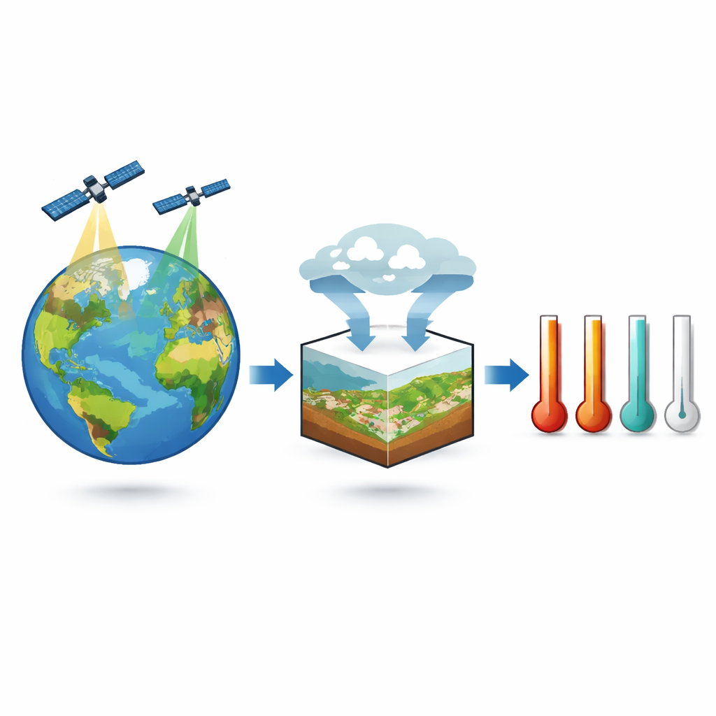
From deciding what to wear next week to managing crops, power grids, and wildfire risk, we all rely on accurate temperature forecasts. Yet even with powerful supercomputers, weather models still struggle, especially beyond a few days ahead. This study explores a simple but underused idea: making forecasts smarter by paying closer attention to the land itself—how hot the ground is and how actively plants are growing—using global satellite data.
Looking at Earth from above
Modern weather forecasts are driven mainly by information about the air: wind, humidity, clouds, and pressure. But satellites have, for decades, been quietly collecting rich information about the land surface. This includes land surface temperature (how hot the ground “skin” is), how green and leafy vegetation is, and a faint glow from leaves called sun-induced fluorescence that reveals how actively plants are photosynthesizing. Traditional forecasting systems mostly ignore these land and plant signals because they can be hard to represent in physics-based models. The authors of this paper set out to test a different approach: instead of forcing satellite data into existing models, they built a separate, flexible deep learning system that could learn directly from both atmospheric and satellite observations.
Teaching a neural network the weather
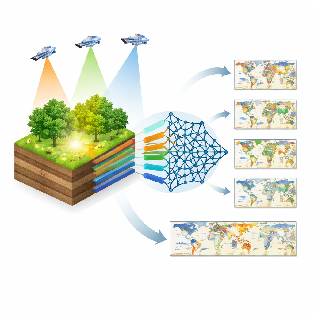
To do this, the team trained thousands of small neural networks known as Long Short-Term Memory (LSTM) models. Each one focused on a specific point on the globe and learned how daily temperature at that point evolved over time. First, they fed the networks only “standard” inputs similar to what traditional weather models use: near-surface air temperature, incoming sunlight and heat, humidity, pressure, rainfall, soil moisture, and snow cover. Then they trained a second set of networks that received the same information plus three satellite-based land variables: land surface temperature, a greenness index, and plant fluorescence. By comparing the performance of these two model families, they could directly measure how much the extra land information helped.
Small numbers, big impact
Across the globe and for forecasts one to twelve days ahead, adding satellite land information consistently made temperature predictions more accurate. On average, forecast errors dropped by about 6–7 percent, corresponding to roughly a quarter of a degree Celsius improvement. The gains were biggest around four days ahead—a crucial “medium-range” window often used for planning. Improvements were especially notable in forests outside the tropics and in semi-arid regions, where the way the land exchanges heat and moisture with the air strongly shapes local temperatures. In many of these areas, satellite-based measures of plant activity and land surface temperature became the single most important predictors, outshining traditional atmospheric inputs.
What plants tell us about tomorrow’s heat
One striking result is that plant fluorescence, a direct sign of photosynthesis, often mattered more than simpler greenness measures. When plants are actively taking up carbon and evaporating water, they cool the surface and influence how incoming energy is split between heating the air and driving evaporation. Because these processes unfold over days, they give forecasts a kind of “memory” of recent land conditions. The neural networks picked up on this connection: where vegetation changes strongly with the seasons and where soil moisture limits plant activity, the added satellite data helped most. In contrast, tropical rainforests—with dense, evergreen canopies and frequent clouds that degrade satellite measurements—showed mixed results, and some grid cells even saw slight degradations linked to data quality issues.
Forecast help when it matters most
The benefits of satellite land information were not limited to just a few days ahead. While the relative improvement shrank at longer lead times—because the atmosphere becomes inherently harder to predict—some regions, such as parts of North America, South America, southern Africa, and western Asia, still gained skill even at 11–12 days. These are the time scales where early warnings for heat waves and cold spells can save lives and reduce economic losses. The study also found that in regions with very sparse or low-quality satellite data, using long-term average patterns of these land variables sometimes worked better than relying on noisy day-to-day measurements, hinting at practical strategies for real-world forecast systems.
A new partnership between satellites and weather models
For non-specialists, the key message is straightforward: the ground and the plants on it hold valuable clues about tomorrow’s air temperature, and satellites are uniquely positioned to capture those clues worldwide. By letting a deep learning system learn directly from these observations, the researchers showed that forecasts can be made meaningfully sharper, especially a few days ahead when many decisions are made. Their work suggests that future operational weather models could become more accurate and more useful by systematically weaving satellite-based land and vegetation information into the forecasting process—combining the strengths of physics-based models and data-driven learning to better anticipate the heat and cold that shape our daily lives.
Citation: Ruiz-Vásquez, M., O, S., Brenning, A. et al. Land surface information from satellites boost near-surface temperature forecast skill. Commun Earth Environ 7, 245 (2026). https://doi.org/10.1038/s43247-026-03298-1
Keywords: satellite land surface data, temperature forecasting, deep learning weather models, vegetation and climate, numerical weather prediction