Clear Sky Science · en
Origin and evolution of the most Mars-like yardang landforms in the Qaidam Basin of Northwest China
Wind-Carved Landscapes on Earth and Mars
The deserts of northwestern China host some of the most otherworldly shapes on our planet: long, streamlined ridges carved by wind called yardangs. These landforms are so similar to features seen on Mars that scientists use them as a natural laboratory for understanding the Red Planet’s surface history. The study summarized here asks a deceptively simple question: when and why did this vast “Mars-like” yardang field in China’s Qaidam Basin form?
A Desert That Looks Like Another World
The Qaidam Basin lies high on the northeastern edge of the Tibetan Plateau, surrounded by three mountain ranges and sitting about 3,000 meters above sea level. Today it is hyperarid: rainfall is often less than a few centimeters per year while evaporation can reach several meters. Vegetation is sparse, temperature swings are extreme, and wind is a constant sculptor. Over roughly 38,800 square kilometers, the basin hosts an astonishing variety of yardangs—ranging from low whale-back forms to sharp ridges and pyramids, some stretching for kilometers. Their streamlined shapes all point in the same general northwest–southeast direction, aligned with dominant winds that funnel through gaps in the Altun Mountains. Yet until now, scientists lacked a basin-wide timeline for when these landforms emerged and what environmental forces drove their growth.

From Ancient Lakes to Wind-Sculpted Ridges
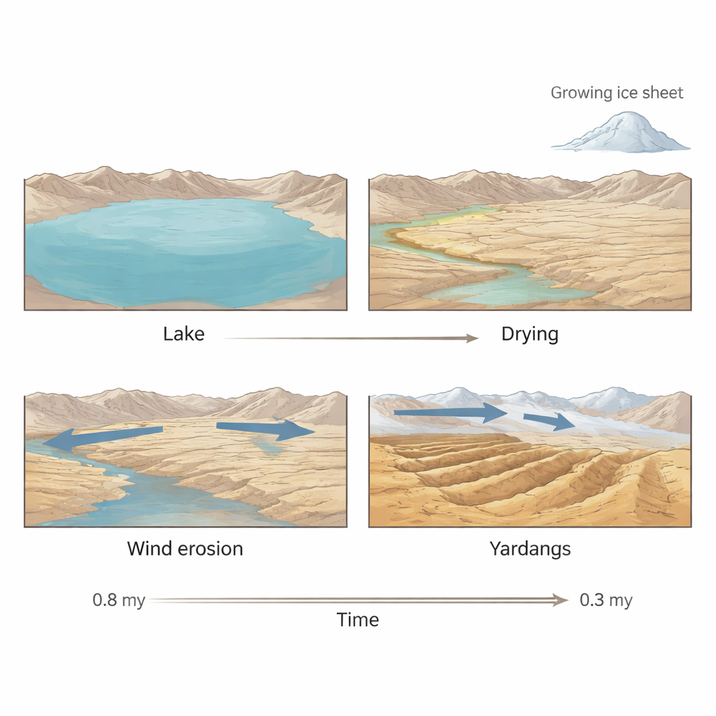
By examining seven representative yardang outcrops across the basin, the researchers show that these sculpted ridges are actually the eroded remains of ancient lake sediments. The rocks are mainly mudstones and siltstones deposited in environments ranging from deep, quiet lakes to shallow shores, storm-battered shallows, and salty playas rich in minerals like halite and gypsum. These soft, layered deposits are weakly cemented and easily broken apart by freezing and thawing, salt crystal growth, and mild chemical weathering, making them ideal raw material for the wind to carve. Beneath today’s dry desert, drill cores reveal that much of the basin was once occupied by large lakes during the early part of the ice age period, forming a patchwork “pan-lake” rather than a single uniform water body.
Reading Time in Grains of Sand
To determine when the lakes dried up and yardangs began to form, the team used two methods that act like tiny clocks inside mineral grains: electron spin resonance (ESR) and optically stimulated luminescence (OSL). Both techniques measure how much natural radiation damage has built up in quartz and feldspar crystals since they were last exposed to sunlight or heat. Eighteen ESR ages and four OSL ages from sand-rich layers within the yardang sequences show a clear pattern across the basin. In the northwest, the uppermost lake sediments dried out around 0.8 million years ago. In the central basin, drying followed between about 0.8 and 0.6 million years ago. Farther southeast, the lakes persisted longer, vanishing between roughly 0.5 and 0.3 million years ago. Because wind carving would have followed soon after lake beds were exposed, these dates effectively mark the stepwise birth of the modern yardang field.
Ice Ages, Stronger Winds, and a Moving Shoreline
The timing of this northwest-to-southeast expansion lines up with major shifts in regional and global climate. Around 0.8 million years ago, during a key turning point in the ice age cycle known as the Mid-Pleistocene Transition, ice sheets across Eurasia grew larger and more persistent. This growth strengthened the Siberian High, a huge dome of cold, dense air that dominates winter weather over northern Asia. Stronger, colder high-pressure systems drove drier conditions and more powerful northwesterly winds into the Qaidam Basin, particularly through mountain gaps in the northwest. Local climate records—from rising salt deposits in lake cores to changing chemical and isotope signatures—show that aridity intensified after 0.8 million years ago and again after about 0.4 million years ago. At the same time, tectonic uplift of the Altun Mountains tilted the basin and pushed lake waters progressively toward the southeast. The combination of shrinking lakes, stronger winds, and changing topography explains the staged march of yardang formation from the windy northwest toward the more sheltered southeast.
What This Means for Understanding Mars
For a non-specialist, the key message is that these striking desert ridges are the fossils of vanished lakes, carved by wind once the climate turned much colder and drier. In the Qaidam Basin, that shift began roughly 0.8 million years ago and unfolded in steps over half a million years, guided by both climate and slow mountain uplift. Mars shows very similar streamlined ridges cut into layered deposits that likely began as lake beds or river deltas. By decoding how Earth’s most Mars-like yardangs formed, this work strengthens the idea that Martian yardangs also record a story of ancient water followed by long-lived dry, windy conditions. In other words, China’s high desert not only reveals how landscapes respond to ice age climate swings, but also provides a crucial window into the environmental history of another planet.
Citation: Sun, J., Lü, T., Zhou, K. et al. Origin and evolution of the most Mars-like yardang landforms in the Qaidam Basin of Northwest China. Commun Earth Environ 7, 177 (2026). https://doi.org/10.1038/s43247-026-03202-x
Keywords: yardangs, Qaidam Basin, Martian analogues, paleoclimate, wind erosion