Clear Sky Science · en
Do rapidly and non-rapidly intensifying tropical cyclones represent two different dynamical regimes
Why some storms rapidly explode in strength
Tropical cyclones—called hurricanes or typhoons depending on where they form—do not all grow in the same way. Some intensify gradually, while others suddenly explode in strength over just a day, catching forecasters and coastal communities off guard. This paper asks a simple but crucial question: do these rapidly intensifying storms follow different underlying rules of behavior from their more slowly strengthening cousins?
Two kinds of storms in a warming world
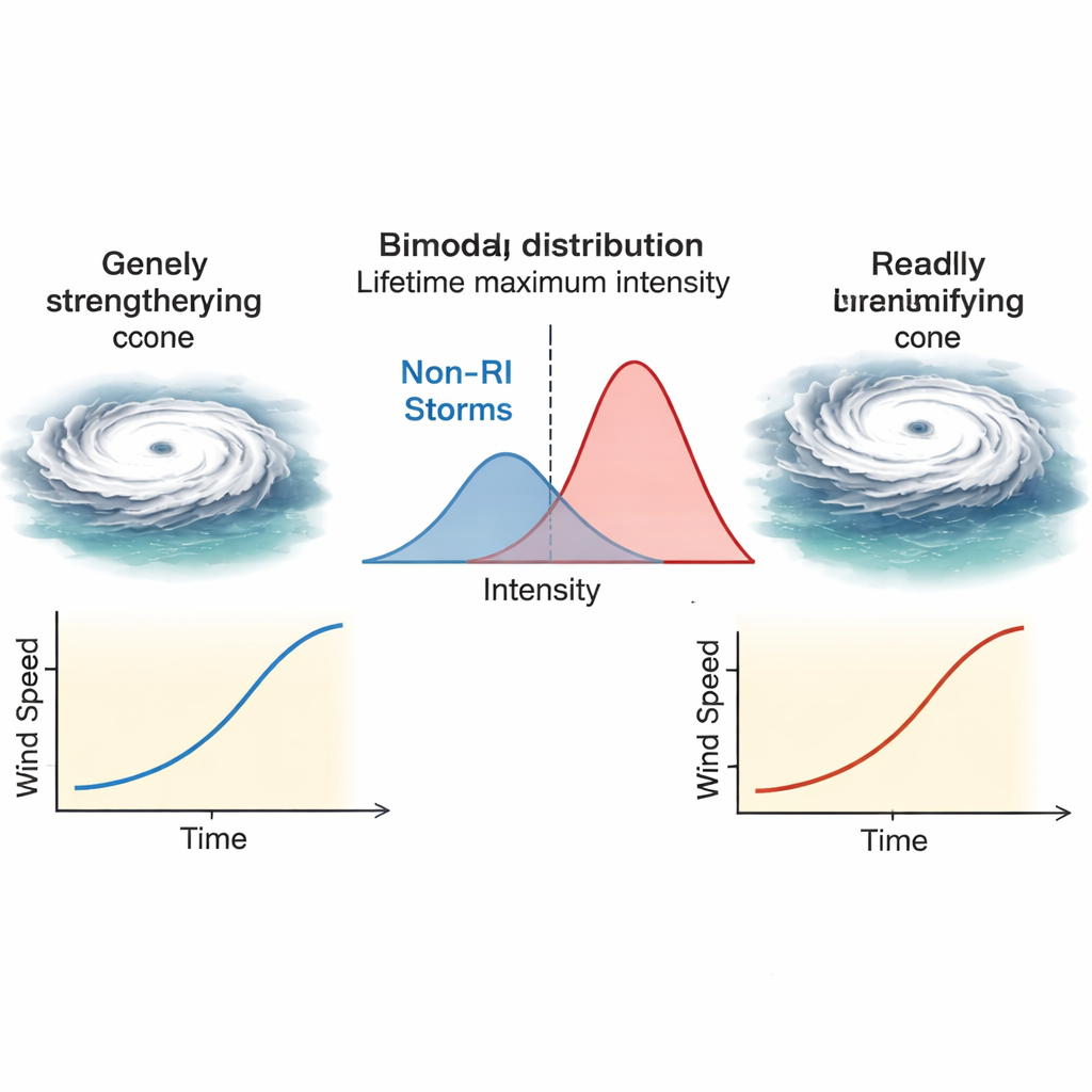
The authors begin by setting the stage in the context of climate change. A growing body of research suggests that while the total number of tropical cyclones worldwide may go down in a warmer climate, a greater share of storms is likely to reach very high peak winds. A key metric is a storm’s “lifetime maximum intensity,” the strongest sustained winds it ever reaches. When scientists look at historical records from 1990 to 2021, this peak intensity does not cluster around a single typical value; instead, it shows two distinct humps, hinting at two different kinds of storms. Earlier work showed that one hump comes from storms that undergo rapid intensification (RI)—defined here as gaining at least 30 knots of wind speed in 24 hours—while the other comes from storms that never do.
Evidence that rapid storms behave differently
Using global best-track data from six ocean basins, the study first confirms how common RI really is. About 40 percent of all tropical cyclones experience at least one RI episode, and nearly every storm that reaches “super typhoon” strength does so. Yet most climate models still cannot realistically simulate the inner core of intense storms, and therefore miss the RI process altogether. The authors then look at how long storms take to reach their peak and how strong they become. For storms that never undergo RI, there is a tight, almost linear link: the longer they have to intensify, the stronger they get, as if they are following a steady, almost clock-like growth rate of roughly 5–10 knots per day. For storms that do experience RI, this neat pattern breaks down. Their final strength no longer depends strongly on how long they had to intensify, implying that their growth rate surges and slackens in a much more erratic way.
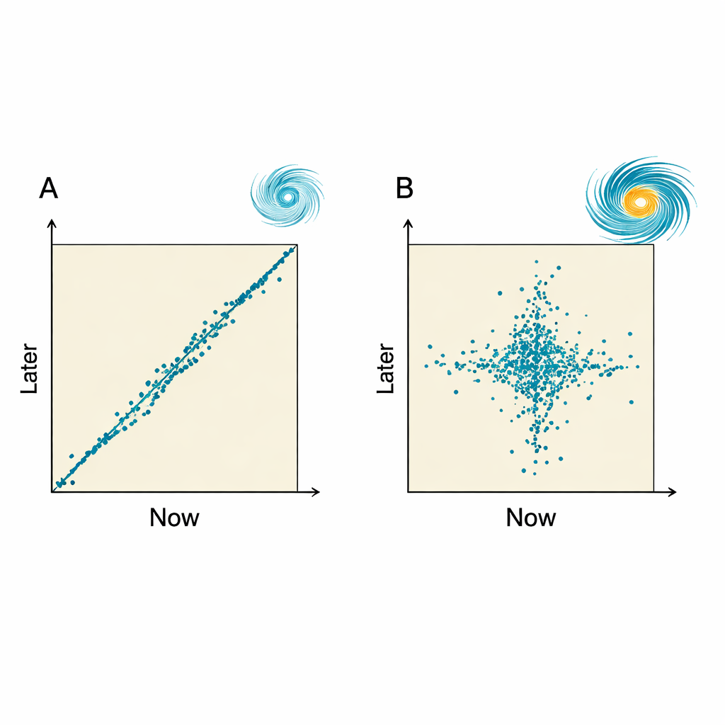
Peering into storm behavior with time-lag maps
To probe this behavior more deeply, the authors borrow a tool from nonlinear dynamics called a lag plot, or phase plot. Instead of graphing wind speed against time, they plot each measurement against the value some hours later—6, 12, or 24 hours into the future—and connect the points in sequence. For two recent landfalling typhoons in China, Yagi (which rapidly intensified) and Bebinca (which did not), the contrast is striking. Bebinca’s path on these plots traces a smooth line close to the diagonal, showing that “later” intensity closely tracks “now,” with a nearly constant rate of strengthening until landfall. Yagi’s path, by contrast, suddenly sprouts vertical and horizontal segments as RI begins, signaling sharp jumps and slowdowns in growth. When the same analysis is repeated for hundreds and then thousands of storms worldwide, the picture holds: non-RI storms cluster along narrow, ordered paths, while RI storms fan out widely, especially at 24-hour lags.
Hidden transitions and forecasting challenges
The authors then ask whether storms destined to rapidly intensify are different from the start, or whether they undergo a sudden transition. By color-coding lag plots for 100 RI storms, they show that before RI begins, their tracks resemble those of non-RI storms, following almost straight lines that imply steady growth. Only when RI starts do the plots abruptly expand into the messy pattern with vertical and horizontal legs. In a simple diagnostic model that assumes future intensity change will follow the recent trend, these sharp bends correspond to large forecast errors. That is, just before and during RI, a forecast based on “persistence” performs very poorly, highlighting a period of inherently limited predictability—one that operational forecast models still struggle with today.
What this means for storms and society
Put in everyday terms, the study suggests that many tropical cyclones live out most of their lives like “steady growers,” intensifying in a fairly predictable, step-by-step manner. Some of them, however, undergo a rapid transformation into a different mode, in which their strengthening becomes burst-like and harder to anticipate. This rapid-intensification regime is not just a stronger version of normal growth; it behaves differently in time and dominates the most destructive storms. Recognizing these two regimes—and the sudden transitions between them—may help scientists design better warning tools and climate models, ultimately improving our ability to anticipate which storms are likely to become the most dangerous.
Citation: McBride, J.L., Tang, L., Yu, Z. et al. Do rapidly and non-rapidly intensifying tropical cyclones represent two different dynamical regimes. npj Clim Atmos Sci 9, 57 (2026). https://doi.org/10.1038/s41612-026-01329-4
Keywords: tropical cyclones, rapid intensification, hurricanes, climate change, storm prediction