Clear Sky Science · en
A super-resolution framework for downscaling machine learning weather prediction toward 1-km air temperature
Sharper Local Forecasts in a Warming World
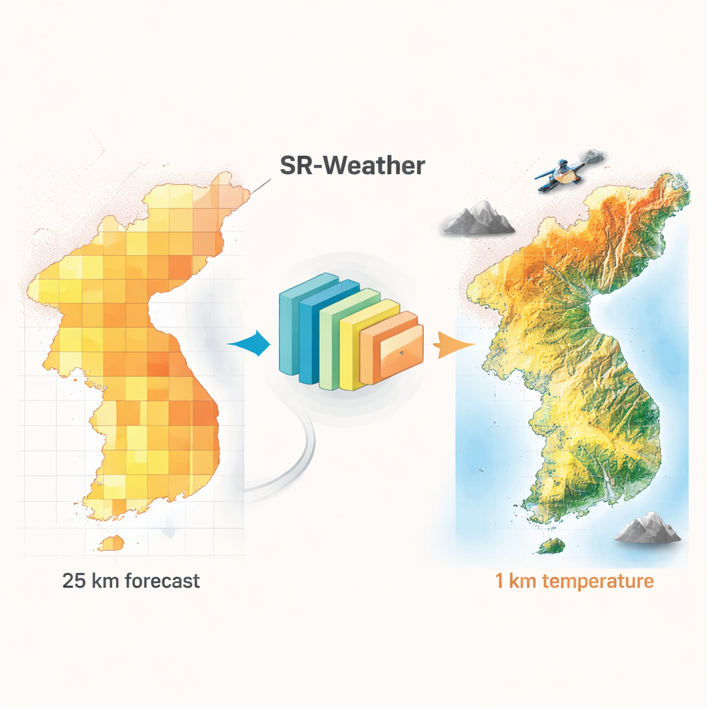
People increasingly want to know not just whether their city will be hot next week, but whether their own neighborhood will swelter or stay bearable. Yet most global weather models still see the world in fuzzy blocks tens of kilometers wide, smoothing over mountains, coastlines, and urban hot spots. This study introduces SR-Weather, an artificial-intelligence system that takes these blurry forecasts and sharpens them into street‑scale temperature maps, aiming to give communities better warning of dangerous heat and other localized extremes.
Why Today’s Forecasts Miss Neighborhood Extremes
Modern weather prediction has made big strides, including new machine-learning models that rival or beat traditional physics-based systems while running much faster. But almost all of these global models operate on grid cells roughly 25 kilometers across. Within a single cell, there might be a cool coastline, a dense city, and forested hills—features that profoundly shape temperature but get averaged into one value. Running full physics-based models at kilometer-scale resolution for days to weeks into the future is still too computationally expensive for routine use. As a result, medium‑range forecasts can’t reliably capture urban heat islands or sharp contrasts between valleys and mountain ridges.
Using Satellites to Add Fine Details
To bridge this gap, the authors designed SR-Weather, a deep-learning “super‑resolution” framework that learns how to turn coarse temperature maps into high‑detail fields at 1‑kilometer resolution. Instead of relying on sparse ground weather stations, they use satellite products as the fine-scale training target. In particular, they start with a global land-surface temperature product from NASA’s MODIS instruments and convert it into daily mean near‑surface air temperature over South Korea. They then pair these satellite-based temperature maps with coarser ERA5 reanalysis data (similar in resolution to modern machine-learning forecasts) for nearly two decades. This allows the network to learn the typical ways that local features—like elevation, land cover, and season—shape temperature patterns inside each coarse grid cell.
Adding Knowledge of Land and Seasons
SR-Weather goes beyond earlier image-enhancement models by explicitly feeding in extra maps that carry important physical context. These include a digital elevation model that resolves mountain ridges and valleys; an “impervious surface” map that indicates how built-up an area is and thus how strong its urban heat island may be; and seasonal climatology maps that summarize where, on average, tends to be warmer or cooler at different times of year. The model’s architecture is tuned to pay special attention not just to average conditions but also to local peaks and dips in temperature, using pooling operations that highlight extremes rather than smoothing them away. In tests against other advanced super‑resolution approaches, SR-Weather delivered the lowest errors and highest correlations with satellite-derived temperatures, especially in high mountains and dense cities where small‑scale structure matters most.
From Better Pictures to Better Forecasts
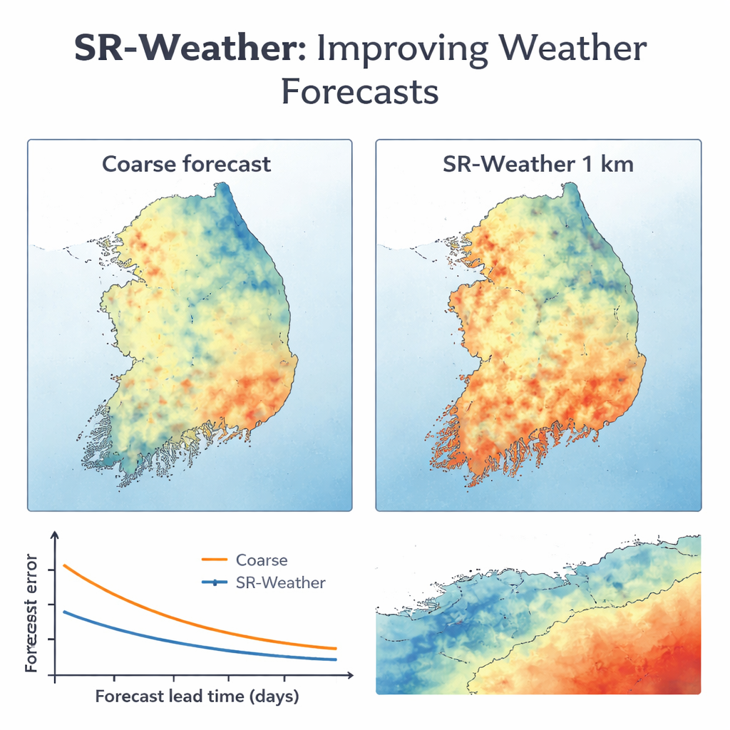
After training on historical ERA5 and satellite data, the team applied SR-Weather to real forecasts from FuXi, a leading global machine‑learning weather model that predicts up to 15 days ahead at 25‑kilometer resolution. SR-Weather transformed FuXi’s coarse daily temperature fields into 1‑kilometer maps over South Korea and was evaluated against dense networks of ground stations. Across lead times of 1–7 days, the super-resolved forecasts consistently matched station data better than simple interpolation and even outperformed Korea’s operational high-resolution numerical model (LDAPS) at short ranges. Notably, a 7‑day SR‑Weather forecast from FuXi beat a 1‑day forecast obtained by just interpolating the coarse fields, showing that the method not only adds detail but also corrects systematic biases using information about terrain and urbanization.
What This Means for Everyday Weather Users
To a non‑specialist, the core message is that we can now use fast, global AI weather models and “zoom in” on the results to the neighborhood scale without running costly supercomputers. SR-Weather learns from satellites where cities, mountains, and coasts tend to heat or cool differently and uses that knowledge to sharpen and adjust future temperature forecasts. Although the study focused on South Korea, the same ingredients—MODIS satellite products and basic land-surface maps—are available worldwide, meaning similar systems could be trained for many regions. As extreme heat becomes more common, tools like SR-Weather could help city planners, power-grid operators, and public-health officials see which districts are most at risk days in advance, enabling more targeted and timely responses.
Citation: Park, H., Park, S., Kang, D. et al. A super-resolution framework for downscaling machine learning weather prediction toward 1-km air temperature. npj Clim Atmos Sci 9, 56 (2026). https://doi.org/10.1038/s41612-026-01328-5
Keywords: weather forecasting, super-resolution, urban heat islands, satellite data, machine learning