Clear Sky Science · en
Multidisciplinary approaches to lithological discrimination and structural mapping for mineral resource assessment
Why This Rocky Desert Matters
Hidden beneath the bare hills of Egypt’s Eastern Desert lie metals that modern society depends on, from gold for electronics to radioactive elements used in medicine and energy. Yet the rocks that host these resources are tangled and deformed, making it hard to know where to look without costly drilling. This study shows how scientists can "X‑ray" such complicated landscapes from the air and space, combining satellite images, magnetic measurements, and fieldwork to zero in on the most promising zones for future mining while limiting environmental disturbance.
A Window into an Ancient Mountain Belt
The research focuses on Wadi Shait in Egypt’s Southern Eastern Desert, part of the Arabian–Nubian Shield, an ancient belt of rocks that formed when fragments of continental crust collided more than 600 million years ago. Two key rock groups dominate the area. The Gardan Ophiolitic Mélange is a jumbled package of old ocean-floor rocks that have been squeezed, sheared, and metamorphosed. Cutting into it is the Shait Granite Complex, a large body of once-molten rock that later hardened and was uplifted. Over time, repeated tectonic pulses fractured and folded these rocks, creating a dense network of faults and shear zones. Those structures now act as pathways and traps for metal-rich fluids, meaning they strongly control where gold and radioactive minerals ended up.
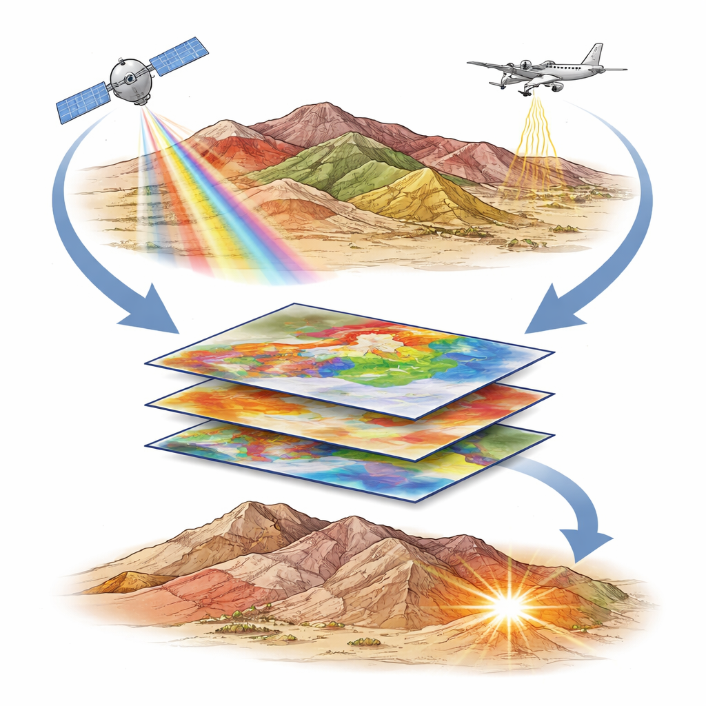
Seeing the Rocks from Space
To sort out this geological maze, the team first turned to satellite imagery. Multispectral data from the European Sentinel‑2 mission and hyperspectral data from the Italian PRISMA satellite record how sunlight is reflected from the ground at many wavelengths. Different rock types and alteration minerals—such as iron oxides and hydroxyl-bearing clays formed by hot fluids—have distinctive spectral “colors.” By using false-color composites, statistical methods that compress many bands into a few key images, and tailored band ratios, the researchers sharply separated the main rock units. They could, for example, distinguish the dark ophiolitic rocks from various volcanic and granitic bodies, and isolate zones where alteration minerals cluster along particular fault trends. The close match between these satellite-derived patterns and existing maps, as well as known small mines and even illegal workings, confirmed that remote sensing can reliably flag mineralized zones at the surface.
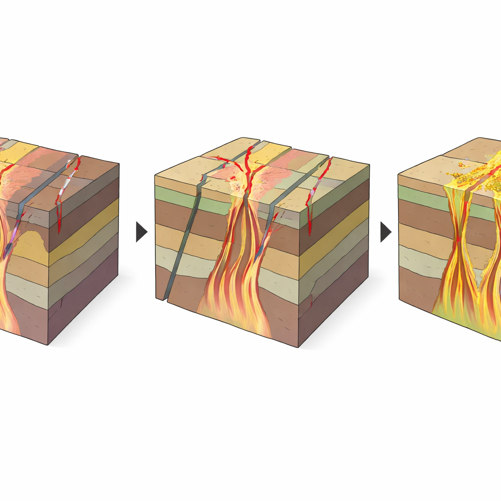
Listening to the Magnetic Heart of the Crust
Surface images alone, however, cannot reveal the full three-dimensional architecture that channels mineralizing fluids. For that, the team analyzed legacy aeromagnetic data, collected by aircraft measuring tiny variations in Earth’s magnetic field. Different rock types and structures influence this field in characteristic ways. After carefully cleaning and transforming the data, the researchers applied a suite of edge-detection filters that sharpen the boundaries of buried bodies and faults. They then used 3D mathematical tools to estimate the depths and shapes of these sources and to construct a model of the basement rocks beneath younger sediments. The results show several sets of faults trending northwest–southeast, northeast–southwest, north–south, and east–west, extending down to depths of roughly 124–782 meters. A three-dimensional magnetic model indicates that the top of the magnetic basement lies a few hundred meters below the surface and rises and falls in ways that focus fracturing and fluid flow.
Where Structure, Depth, and Fluids Meet
Combining satellite maps, magnetic models, and detailed field measurements, the researchers built a structural blueprint of Wadi Shait. They found that northwest-trending shear zones related to a regional fault system not only shaped the uplift of the Shait granite dome but also created extensional pockets—small zones of local stretching—where granite magmas, and later hot, metal-bearing fluids, could rise. Advanced image-analysis techniques highlighted places where many faults intersect, where rock textures are especially complex, and where the basement lies relatively shallow. These spots often coincide with clusters of alteration minerals seen in PRISMA data and with existing or abandoned workings, marking them as especially favorable for undiscovered gold and radioactive mineral deposits.
What This Means for Finding Future Resources
In plain terms, the study shows that the richest mineral targets in this part of the Eastern Desert occur where three ingredients overlap: a dense web of fractures and shear zones, basement rock that is not too deep, and clear signs of chemical alteration left by hot fluids. By fusing satellite imagery, aircraft magnetics, and boots-on-the-ground geology into a single workflow, the authors demonstrate a powerful, relatively low-impact way to narrow huge, complex terrains down to a handful of high-priority prospects. Their approach can be exported to other hard-to-map regions worldwide, helping guide more efficient and sustainable exploration for the metals and minerals that underpin modern technology.
Citation: Elfadly, M.A., Abdelrady, M., Decarlis, A. et al. Multidisciplinary approaches to lithological discrimination and structural mapping for mineral resource assessment. Sci Rep 16, 9079 (2026). https://doi.org/10.1038/s41598-026-43824-x
Keywords: mineral exploration, remote sensing, aeromagnetic mapping, structural geology, gold deposits