Clear Sky Science · en
High-resolution XRF-CS/ICP-MS mineral element data calibration and potential applications in sub-Antarctic peat records
Winds, Dust, and Hidden Climate Clues
Far from the hustle of cities, soggy mosslands on remote sub-Antarctic islands quietly record the story of our planet’s changing winds and climate. These peatlands, built up over thousands of years, trap tiny grains of mineral dust blown in from afar. By learning to read this dusty record in far greater detail than before, scientists can better understand how powerful Southern Hemisphere winds and the surrounding oceans have shifted over time—and how they may change in the future.
Why Island Bogs Matter
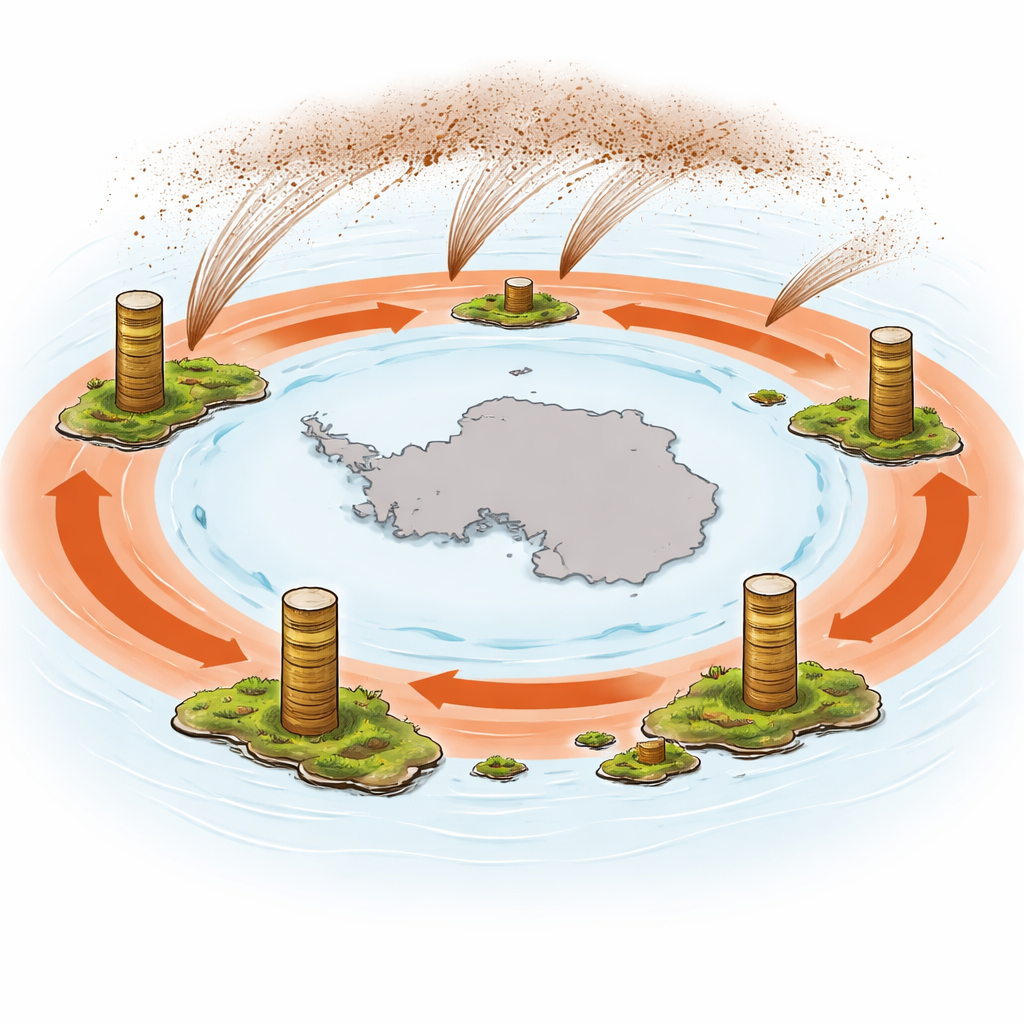
Peatlands are natural “tape recorders” of the atmosphere. Layer by layer, they preserve dust and ash carried by winds from distant continents and volcanoes. In the Southern Ocean, a ring of strong westerly winds races around Antarctica. These winds stir the ocean, helping control how much carbon dioxide the water absorbs or releases. The few islands that poke up in this stormy belt—such as Bird Island, Isla Hermite, Kerguelen, and Marion Island—host peat bogs that have been accumulating for up to 18,500 years. By studying the mineral dust locked in these peat layers, researchers can reconstruct past wind strength and direction across the Southern Ocean.
The Challenge of Reading Dust in Peat
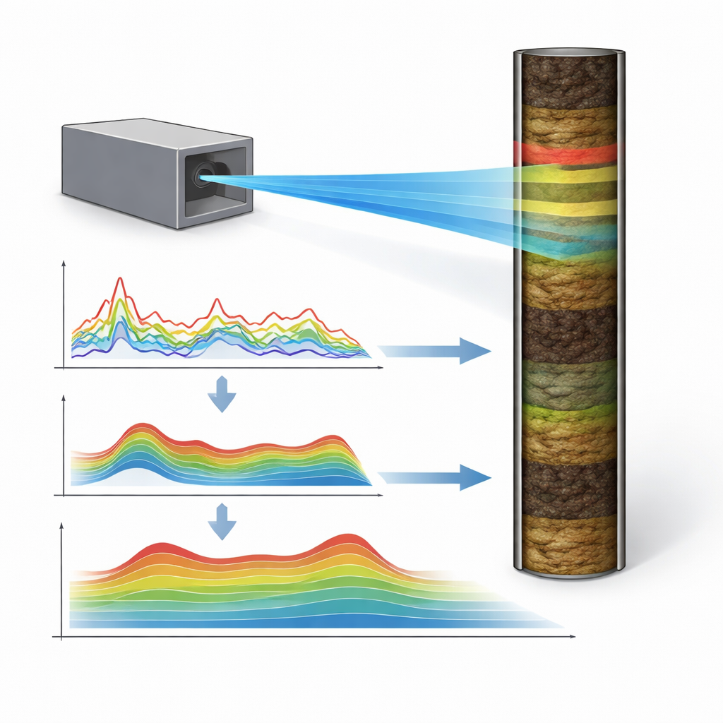
The mineral grains buried in peat are tiny and sparse, mixed into a soft, water‑rich, and mostly organic material. Traditional laboratory methods, such as dissolving samples and measuring them with a mass spectrometer, provide accurate mineral counts but are slow, expensive, and destructive. Each measurement usually averages about a centimeter of peat, often representing centuries of time. That means many fine swings in wind and dust activity are blurred together or missed entirely. Faster scanning methods, like X‑ray fluorescence core scanning, can measure the chemistry of intact cores every millimeter or less, but they normally produce only raw signal counts, not true concentrations that can be compared across sites and studies.
Turning Fast Scans into Hard Numbers
The authors tackled this bottleneck by carefully calibrating rapid X‑ray scans against a large set of high‑quality laboratory measurements. They collected peat cores from five sites on four sub‑Antarctic islands, spanning everything from nearly pure plant material to peat heavily mixed with mineral grains and volcanic ash. For each core, they made more than 14,000 closely spaced X‑ray measurements and paired them with 268 traditional laboratory measurements of key elements, including titanium and zirconium, which are widely used as markers of mineral dust. Using advanced statistical techniques, they tested eight different calibration approaches to see which could best convert the raw X‑ray counts into reliable, quantitative element concentrations.
Finding the Best Way to Calibrate
The team found that a multivariate method called partial least squares worked best when it focused on four elements—calcium, titanium, strontium, and zirconium. This approach takes advantage of how these elements vary together in the peat, allowing the model to handle the complex mixture of organic matter, water, and minerals. For titanium, the resulting calibration produced strong agreement between predicted values from the X‑ray scans and the independent lab measurements across all sites. Zirconium proved more difficult because its levels were often very low, but the calibrated values were still helpful, especially where volcanic ash layers were present. Importantly, this method kept noise under control, avoiding the erratic behavior seen in some machine‑learning models that fit the data too tightly.
Peering into Climate’s Past in Fine Detail
With this new calibration in hand, the researchers could transform the entire X‑ray record into high‑resolution dust concentration profiles for each peat core. On average, the X‑ray method can now resolve changes every couple of years, compared with centuries between traditional samples. This sharp jump in detail makes it possible to pick out multi‑decade to multi‑century shifts in mineral dust input that likely reflect changes in the strength and position of the Southern Hemisphere westerly winds. Because peatlands are widespread around the globe, the same protocol can be applied well beyond the sub‑Antarctic, opening the door to much finer reconstructions of past storms, atmospheric circulation, and their links to ocean carbon storage.
What This Means for Our Understanding of Climate
In simple terms, this study shows how to turn a fast but fuzzy scanning technique into a precise tool for reading the dust record stored in peat. By accurately converting X‑ray signals into real mineral concentrations, scientists can now use peat cores to trace wind‑blown dust at time scales that approach individual human lifetimes, rather than broad slices of centuries. This step change in resolution will help researchers better connect natural wind and climate shifts of the past with the behavior of today’s atmosphere and oceans, improving our understanding of how the climate system responds to change.
Citation: De Vleeschouwer, F., Roberts, S.J., Le Roux, G. et al. High-resolution XRF-CS/ICP-MS mineral element data calibration and potential applications in sub-Antarctic peat records. Sci Rep 16, 8909 (2026). https://doi.org/10.1038/s41598-026-41047-8
Keywords: peat cores, mineral dust, Southern Hemisphere westerlies, XRF calibration, paleoclimate