Clear Sky Science · en
Remote sensing and geochemical constraints on polymetallic mineralization in Abu Rusheid and Sikait granites of Egypt
Why Hidden Metals in Desert Rocks Matter
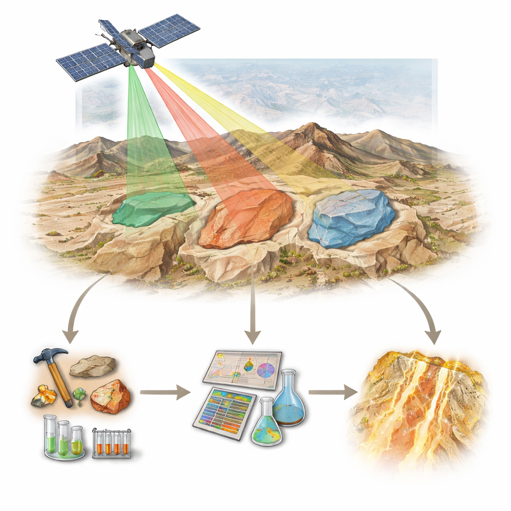
Smartphones, wind turbines, and electric cars all depend on obscure elements with names like niobium, tantalum, and rare earths. Many of these metals are locked away in hard-to-reach rocks in remote deserts. This study focuses on a rugged area of Egypt called Abu Rusheid–Sikait, where unusual granites host a cocktail of valuable metals including rare earths, zirconium, niobium, tantalum, and uranium. The researchers combine satellite imaging, artificial intelligence, field geology, and laboratory chemistry to show how these metals became concentrated and how we can efficiently search for similar deposits elsewhere.
Rocks in a Remote Desert
The Abu Rusheid–Sikait area lies in Egypt’s Eastern Desert, part of the Arabian–Nubian Shield, a large belt of ancient crust that formed when continents collided hundreds of millions of years ago. Here, several generations of rocks are exposed: old deformed gneisses and slices of ancient ocean crust, cut by younger granites and their coarse-grained offshoots known as pegmatites. Among these late granites are special bodies rich in light-colored mica minerals (muscovite and zinnwaldite) and garnet. These particular granites and associated pegmatites turn out to be especially enriched in rare metals. Their margins are sliced by major fault and shear zones linked to a regional system of fractures that once helped tear the crust apart.
Seeing Minerals from Space
To untangle this complex landscape, the team turned to the Italian PRISMA satellite, which records sunlight reflected from Earth in hundreds of narrow wavelength bands. Different minerals imprint distinct “color” fingerprints across these bands. Using machine-learning methods called Random Forests and Support Vector Machines, the researchers taught a computer to recognize the spectral patterns of ten rock types from field spectra and samples. After cleaning the data to reduce noise, the algorithms mapped the various granites, gneisses, and ophiolitic rocks with close to 90% accuracy. Special combinations of PRISMA bands were then used to highlight zones of alteration—chemical overprints where hot fluids changed the original minerals—such as clay-rich (argillic), mica-rich (phyllic), chlorite–carbonate (propylitic), and iron-oxide (ferrugination) halos.
What the Rocks Reveal in the Lab
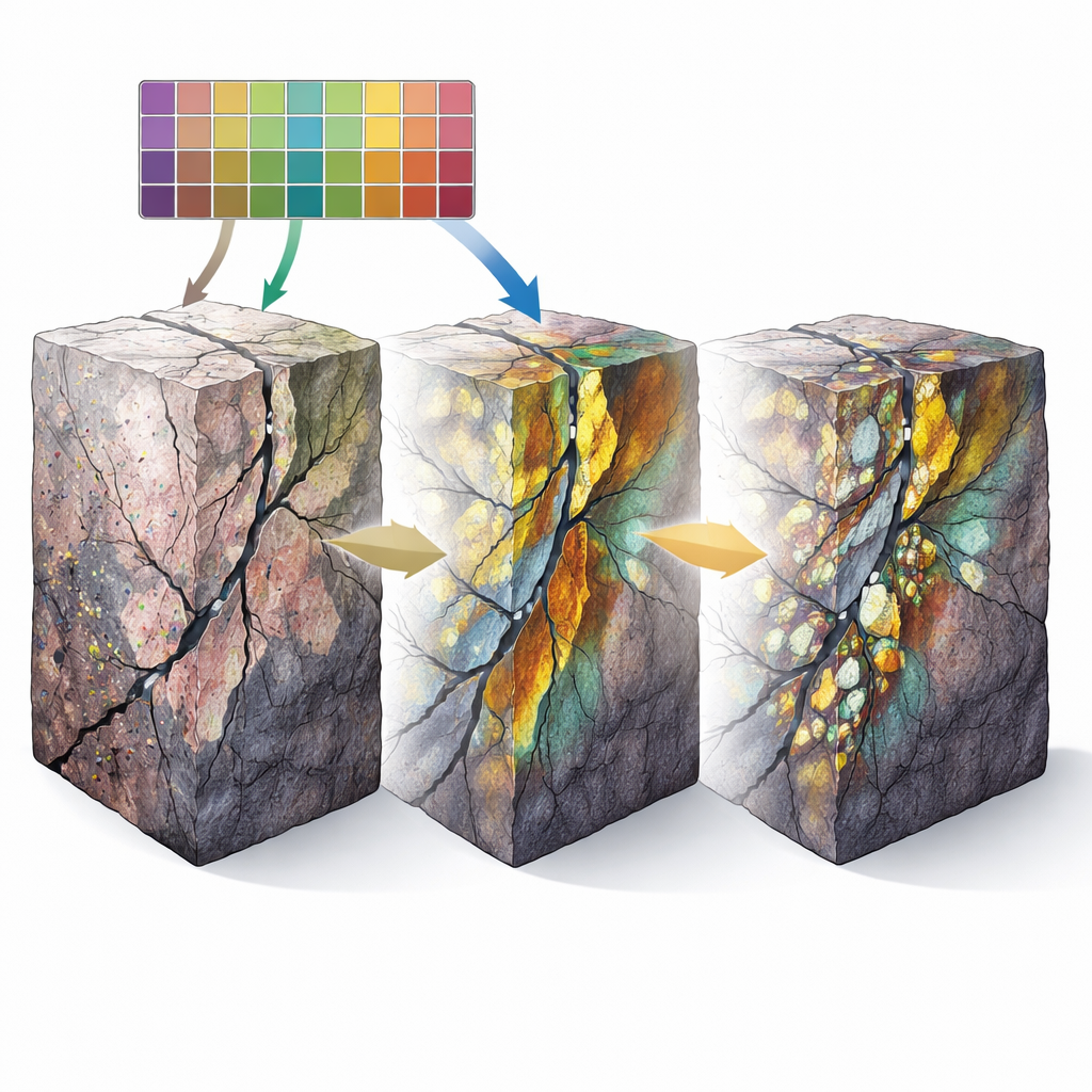
Back in the laboratory, thin slices of rock and detailed chemical analyses revealed how unusual these granites are. They are silica-rich, slightly aluminum-rich, and belong to a class called A-type granites, often associated with technology metals. In the Abu Rusheid–Sikait area, the muscovite–garnet and zinnwaldite-bearing granites and their pegmatites contain exceptional levels of rare earth elements (up to about 1,300 parts per million), zirconium, niobium, tantalum, uranium, thorium, and lead. Under the microscope, these elements are hosted in tiny accessory minerals such as zircon, columbite, monazite, xenotime, thorite, and later uranium minerals like kasolite, as well as occasional galena for lead. Chemical patterns show that the magmas evolved through strong fractionation—successive crystallization and removal of common minerals—which concentrated rare metals in the remaining melt before it finally froze.
Faults, Fluids, and Metal Hotspots
The story does not end with the solidification of granite. Radar images from other satellites were used to automatically extract long linear features that mark faults and fracture zones. These trends—mainly northwest–southeast, north–south, and northeast–southwest—match structures seen in the field and under the microscope. Along these fractures, the rocks show intense alteration: clays replacing feldspar, mica overgrowing older minerals, and rusty red and brown patches where iron oxides formed. Geochemical data reveal that uranium and some rare earths are especially enriched where iron oxides and secondary uranium minerals occur, indicating that hot, oxidizing fluids moved along the fractures, dissolved metals from magmatic minerals, and re-precipitated them in narrow zones. By combining the remote sensing of alteration, the density of fractures, and the locations of the most evolved granites, the authors built a “prospectivity map” that outlines three new top-priority zones for exploration.
From Desert Map to Metal Resources
Together, the work paints a two-stage picture that can guide future searches for critical metals. First, unusual granites formed during a late stage of mountain building produced primary enrichment of rare metals through magmatic processes. Later, fluids channeled by major fault systems partially redistributed and focused some of these elements—especially uranium and lead—along fractures and in altered halos rich in iron oxides and clays. By fusing satellite hyperspectral data, machine learning, structural analysis, classical field geology, and geochemistry, the study offers a practical recipe for finding similar polymetallic systems elsewhere in the Arabian–Nubian Shield and beyond, helping to locate the resources needed for modern technologies while reducing the amount of costly, blind exploration on the ground.
Citation: Abo Khashaba, S.M., El-Shibiny, N.H., Hassan, S.M. et al. Remote sensing and geochemical constraints on polymetallic mineralization in Abu Rusheid and Sikait granites of Egypt. Sci Rep 16, 7832 (2026). https://doi.org/10.1038/s41598-026-40638-9
Keywords: rare metal granites, hyperspectral remote sensing, machine learning geology, uranium and rare earth elements, Arabian Nubian Shield