Clear Sky Science · en
Deep learning inversion of water content and relaxation time in water-bearing fracture zones based on surface NMR data
Why hidden water in rock fractures matters
Far below our feet, water often threads its way through tiny cracks in rock. These hidden veins can be both a vital resource and a serious hazard: they help supply drinking water, but they can also flood mines, weaken tunnels, and trigger landslides. The study summarized here presents a new way to find such water-filled fracture zones from the surface, using a combination of a specialized magnetic method and modern deep learning. The goal is to see not just where groundwater is, but how it is stored and how easily it can move—crucial information for safe engineering and sustainable water use.
Listening to water with subtle magnet signals
The work builds on a technique called surface nuclear magnetic resonance, which is unusual among geophysical tools because it responds directly to the hydrogen in liquid water. On the ground, loops of wire send carefully tuned pulses into the Earth and then listen for faint echo-like signals from underground water. These signals fade over time at rates that depend on how water is held in the rock. Broad, sponge-like pores give one type of decay, while narrow fractures give another. In principle, this time behavior can reveal not only how much water is present, but also whether it resides in porous layers or in crack networks that may channel flow and cause sudden leaks or floods. 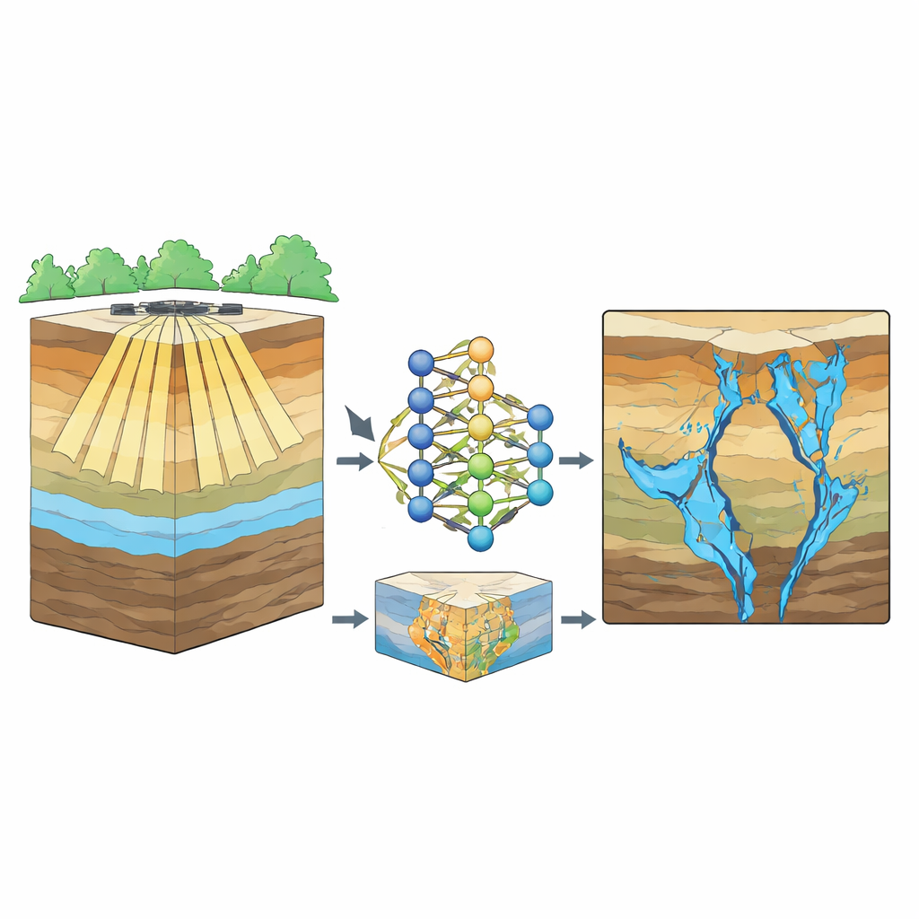
The limits of traditional underground images
Conventional methods for turning these signals into subsurface images rely on iteratively fitting mathematical models to the measured data. This established "QT inversion" approach works well for broad, water-rich aquifers, but struggles with thin or deep fracture zones. Their signals are weaker, often masked by overlying layers with more water, and can be smoothed away by the regularization tricks used to keep the math stable. The process is also computationally heavy: to obtain a reliable picture, specialists must repeatedly adjust penalty terms and constraints, which is slow and not ideal when real-time decisions are needed in mining or tunneling projects.
Teaching a neural network to see fractures
To overcome these limits, the authors recast the problem as one of pattern recognition. They built thousands of realistic synthetic models of underground geology, combining layered porous aquifers with randomly generated fracture networks of different lengths, angles, and densities. For each model, they simulated the expected magnetic resonance signals, added realistic noise, and labeled the true underground distribution of four key quantities: water content and relaxation time for both porous layers and fracture zones. They then trained a convolutional neural network—an image-focused deep learning architecture—to learn the direct mapping from full signal records to these four underground maps. In effect, the network becomes a fast, learned "inverse" that bypasses much of the traditional tuning.
Sharper pictures, faster answers
Tests on unseen synthetic examples showed that the trained network could clearly distinguish porous aquifers from water-filled fractures across a two-dimensional cross-section. It reproduced the shapes and positions of fracture zones, even when they were inclined or clustered, and captured their characteristic, longer relaxation times. Some blurring and underestimation occurred at the edges of small, deep features, where the signals are weakest, but overall errors were modest. When compared directly with a standard regularized inversion, the deep learning method delivered crisper boundaries, fewer artifacts at depth, and markedly lower average errors—all while reducing the actual inversion run time from about half an hour to just a few seconds once training was complete. Robustness tests with increasing noise levels showed that, although fine details degrade, the main fracture zones and aquifers remain recognizable even under fairly poor signal conditions. 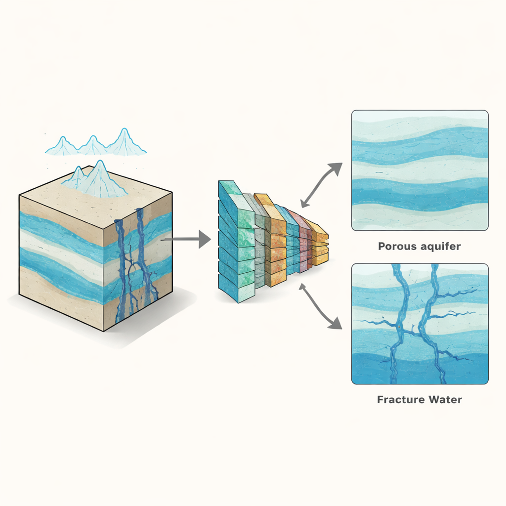
From numerical tests to real-world rock
The authors applied their trained network to field data from a coal mining area in northern China, where weathered bedrock beneath younger sediments hosts a fracture-controlled aquifer that can threaten mine safety. Standard inversion showed the expected shallow porous aquifer but did not reveal any clear deeper fracture zone. In contrast, the deep learning inversion highlighted a distinct, band-like water-bearing zone within fractured bedrock at depths of around 18 to 30 meters along part of the survey line. Independent borehole observations confirmed that this interval was heavily fractured and water-bearing. A pumping test in one borehole provided an estimate of how easily water flows through the rock, which agreed closely—within about 10 percent—with values inferred from the new inversion, lending real-world support to the method.
What this means for water and safety underground
In plain terms, this study shows that combining a water-specific sensing method with deep learning can make previously hidden water-filled fractures much easier to see from the surface. The approach separates slow-moving pore water from potentially hazardous fracture water and provides estimates of how much water is present and how readily it can move. While the method still depends on good training data and can blur very small or deep features, it offers a rapid, non-invasive way to map risky fracture zones and support safer mine planning, tunnel design, and groundwater management in complex rock terrains.
Citation: Li, K., Li, H., Qiu, H. et al. Deep learning inversion of water content and relaxation time in water-bearing fracture zones based on surface NMR data. Sci Rep 16, 9292 (2026). https://doi.org/10.1038/s41598-026-40506-6
Keywords: groundwater, rock fractures, nuclear magnetic resonance, deep learning, geohazards