Clear Sky Science · en
Drone-based composite risk mapping reveals vegetation–shade interaction and housing typology as key determinants of Aedes habitat risk
Why Your Backyard Matters for Dengue
Dengue fever is spread by Aedes mosquitoes that often breed just a few meters from where people live, work, and play. This study shows how everyday features such as trees, hedges, narrow side yards, and water containers can quietly turn certain kinds of housing into mosquito “hotspots.” Using camera‑equipped drones and advanced mapping, researchers in Shah Alam, Malaysia, reveal how the mix of vegetation, shade, and building layout determines where Aedes mosquitoes are most likely to thrive—and how cities can use this knowledge to target dengue control far more precisely.
Looking Down from the Sky
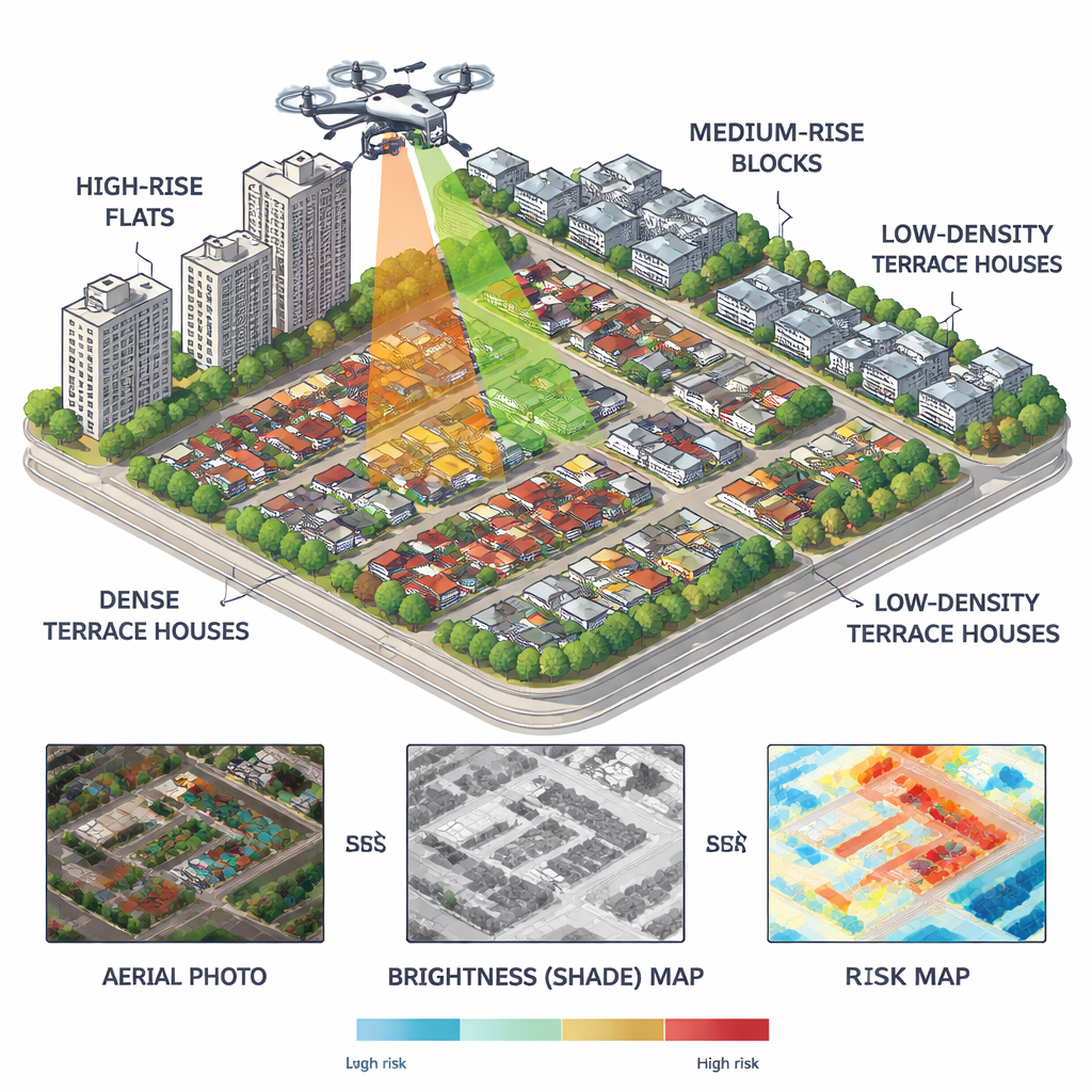
The team flew a small drone over a mixed neighborhood that included high‑rise flats, medium‑rise blocks, tightly packed terrace houses, and more spacious terrace homes with larger yards. From the drone images, they created detailed maps where each pixel covered just a few centimeters on the ground. They then calculated two simple measures from the color images: how green an area was (a stand‑in for vegetation like grass, shrubs, and trees) and how bright or dark it appeared (a stand‑in for sun or shade). Darker areas tended to stay shaded, while greener areas held more plants and leaf litter—conditions known to help Aedes mosquitoes.
Blending Greenery and Shade into a Risk Score
Instead of looking at vegetation or shade alone, the researchers built a Composite Risk Index that becomes high only where both are strong at the same spot—places that are both green and consistently shaded. This index ranges from 0 (very low risk) to 1 (very high risk) and is mapped continuously across the neighborhood. They checked the map against on‑the‑ground inspections of drains, pots, buckets, and other water‑holding objects that could serve as breeding sites. The match was striking: the top fifth of high‑risk pixels on the map contained nearly two‑thirds of all the breeding‑prone locations found in the field, and the overall agreement between predicted risk and real‑world findings was very high.
Why Some Homes Become Mosquito Magnets
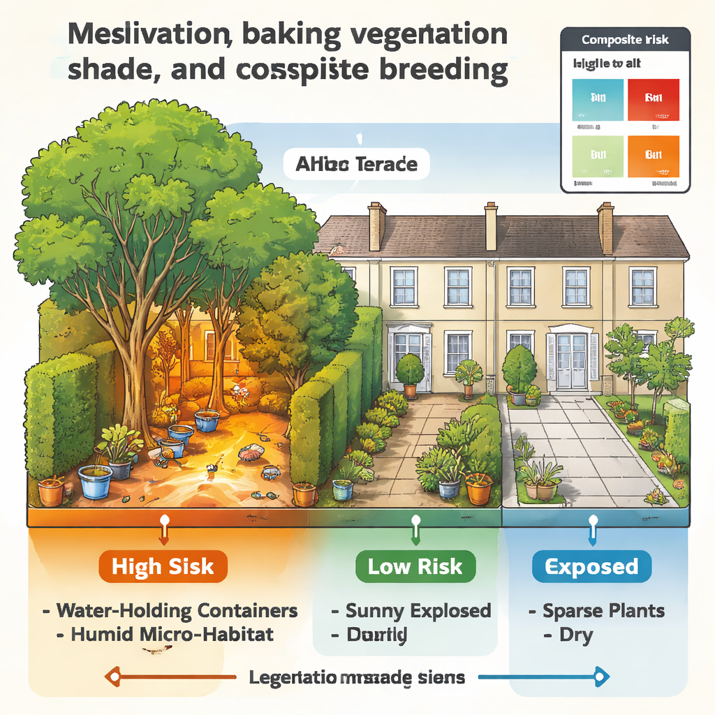
Although all housing types had at least some greenery, the way buildings and plants were arranged made a big difference. High‑rise and medium‑rise flats had patches of trees and small gardens, but they were often exposed to direct sun and surrounded by hard concrete surfaces that dried quickly. Their risk scores were mostly low to moderate, and actual breeding spots were scattered and short‑lived. In contrast, terrace houses—especially those with larger lots—had continuous belts of backyard vegetation, side‑yard hedges, and narrow passages between homes. These spaces trapped humidity, stayed shaded for long periods, and sheltered water‑holding containers. On the risk maps, these terrace zones showed dense clusters of high scores, and ground surveys confirmed many more breeding‑prone spots there than around the flats.
Hidden Patterns in Everyday Spaces
To better understand what was happening on the ground, the researchers grouped common urban features into four patterns. Building perimeters—especially north‑ and east‑facing walls—created regular strips of shade along drains and walkways. Corners and junctions between structures collected runoff and debris, giving rise to short‑term but favorable breeding niches after rain. Rows of shade trees in parking areas formed humid corridors used by resting adult mosquitoes. Most important were private rear yards and boundary hedges, where dense vegetation and poor air flow produced stable, moist pockets that stayed suitable for Aedes even when the weather was dry. These private green pockets lined up closely with the highest risk scores on the drone‑derived maps.
Turning Maps into Action
For non‑specialists, the study’s message is clear: dengue risk is not spread evenly across a city but concentrates where greenery and long‑lasting shade overlap around certain housing types, especially terrace homes with lush, semi‑hidden yards. By using drones to map these micro‑habitats, health agencies can move beyond broad spraying campaigns and instead focus on the specific lanes, backyards, and garden edges that matter most. For residents, it highlights practical steps: manage shaded vegetation near the home, clear gutters and drains, and remove or cover containers that can hold water in dark, leafy corners. Together, these actions can turn high‑risk “mosquito habitats” back into safer, healthier living spaces.
Citation: Mahfodz, Z., Naba, A., Isawasan, P. et al. Drone-based composite risk mapping reveals vegetation–shade interaction and housing typology as key determinants of Aedes habitat risk. Sci Rep 16, 5957 (2026). https://doi.org/10.1038/s41598-026-39951-0
Keywords: dengue, Aedes mosquitoes, drone mapping, urban housing, mosquito breeding sites