Clear Sky Science · en
A geospatial model of entry pathways of lumpy skin disease virus introduction into Australia
Why this matters for Australia’s cows and economy
Lumpy skin disease is a serious viral illness of cattle and buffalo that has been marching steadily across Asia and has now reached Australia’s doorstep in Indonesia. If it arrived and spread in Australian herds, the country could face major trade losses for beef, dairy, and live cattle. This study asks a practical question: if the virus does get close, where along Australia’s vast northern edge are insects most likely to carry it in, and at what times of year? The answers can help authorities focus surveillance and control where it will count most.
How insects can carry disease across the sea
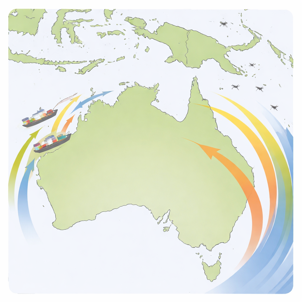
Lumpy skin disease virus does not usually jump directly from cow to cow. Instead, it hitches a ride on biting insects such as mosquitoes, midges, and stable flies, which can mechanically transfer the virus from an infected animal to a healthy one. Because Australia imports very few live cattle and enforces strict quarantine at its borders, the main concern is not sick animals on ships, but infected insects that arrive in two ways: clinging to cargo ships and other vessels, or being swept up and blown long distances by strong winds from neighboring countries where the disease is present.
Mapping where risky insects and sick animals live
The researchers first set out to understand where, in surrounding countries, infected cattle and the right kinds of insects are most likely to be found. They combined global livestock maps, official reports of lumpy skin disease outbreaks since 2018, and online records of insect sightings. With statistical models, they created probability maps showing where potentially infected bovines are concentrated, and where flying insects capable of carrying the virus are most likely to occur. These maps pointed to hot spots in India and across parts of Southeast Asia, including the Indonesian island of Java, as important sources of both infected animals and suitable insect vectors.
Ships, wind, and the most exposed Australian coasts
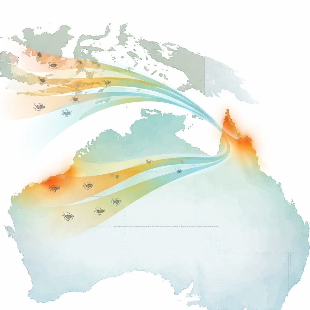
Next, the team built two separate models for how infected insects might reach Australia. In the shipping pathway, they identified 138 overseas ports across 16 countries and 66 Australian ports. For each Australian port, they combined how suitable the nearby overseas ports were for harboring infected insects, how much those countries trade with Australia, how often ships call at each port, how far they travel, and how often local temperatures are warm enough for insects to survive. This approach revealed that, among all ports, Port Hedland and Dampier in Western Australia stand out with the highest relative suitability for insect-borne virus arrival, largely because of heavy trade traffic rather than short distances alone.
When the wind is most likely to carry insects in
For the wind pathway, the researchers used a widely used atmospheric model to project 48-hour wind trajectories from 195 starting points across Indonesia, Papua New Guinea, and Timor-Leste for every day from 2019 to 2023. They then counted how often these air paths crossed a grid laid over northern Australia and weighted those counts by how suitable each origin area was for harboring flying insects that could be carrying the virus. The results show that Far North Queensland, followed by coastal parts of the Northern Territory and Western Australia up to about 25 degrees south, are the most likely destinations for windborne insects. The risk is strongly seasonal: paths that reach Australia are most frequent during the northern wet season—December through February—then drop sharply in autumn and are rare in winter.
Putting the two pathways together for action
Finally, the study combined shipping and wind results into one overall suitability map for insect-borne virus entry. Most of Australia appears as very low risk compared with a few clearly defined hot spots. The northern tip of Far North Queensland emerges as the single most suitable area for an incursion, while Port Hedland and, to a lesser extent, Dampier in Western Australia also rank highly. Inland northern areas are mostly low suitability, and almost all southern ports and Tasmania are very low. The authors stress that their model does not predict actual outbreaks, and it has limitations—such as not tracking seasonal changes in insect numbers or precisely where insects land—but the pattern was stable even when they varied key assumptions.
What this means for protecting herds
In plain terms, the study suggests that while the overall chance of lumpy skin disease virus entering Australia via insects remains low, a few northern coastal regions are far more exposed than others. By highlighting these specific areas and seasons—particularly Far North Queensland and key ports in Western Australia during summer—this geospatial model can help biosecurity agencies decide where to step up insect monitoring, strengthen port disinsection, and plan rapid responses if the virus ever appears. Future work could extend this approach to ask not just where the virus might enter, but how it could spread within Australia’s cattle population, further sharpening the country’s defenses.
Citation: Owada, K., C. Castonguay, A., Hall, R.N. et al. A geospatial model of entry pathways of lumpy skin disease virus introduction into Australia. Sci Rep 16, 8561 (2026). https://doi.org/10.1038/s41598-026-39806-8
Keywords: lumpy skin disease, vector-borne disease, geospatial modelling, biosecurity Australia, windborne insects