Clear Sky Science · en
Coupling between crustal uplift and magnetic demagnetization in the Tarim Basin
Why the Hidden Heart of a Desert Basin Matters
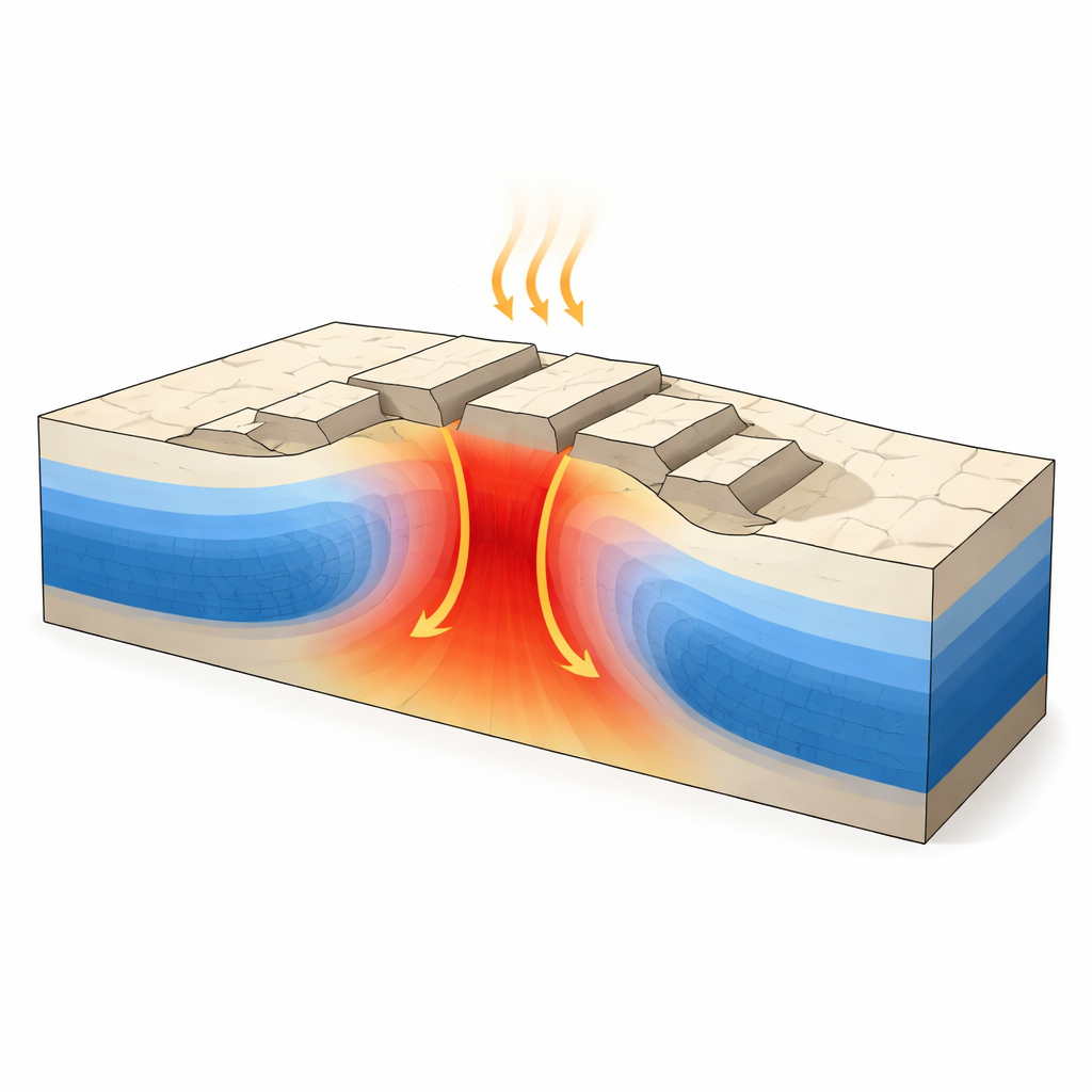
Far beneath the deserts of northwest China lies the Tarim Basin, one of Earth’s deepest sedimentary basins and home to major oil and gas reserves. Yet its ancient crystalline foundation and thermal history remain largely out of reach of conventional seismic imaging. This study uses Earth’s magnetic field as a probe to ask a deceptively simple question with big implications: where the crust has been pushed up into broad underground “highs,” has it also been cooked and chemically altered enough to lose its magnetic strength? The answer helps reveal how deep mantle activity reshaped this cratonic interior and where subsurface conditions may have transformed buried petroleum systems.
Reading Heat History from Invisible Magnetism
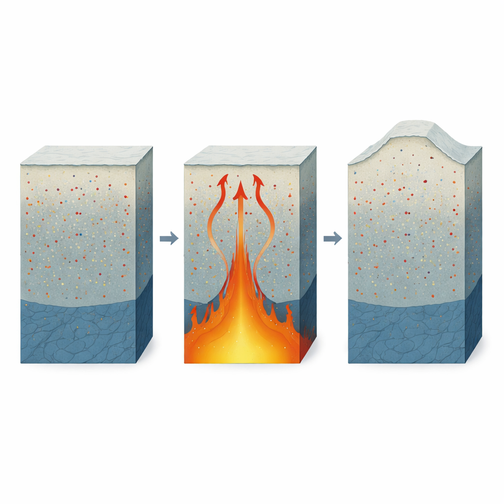
Rocks in the crust act a bit like tiny magnets, but only up to a critical temperature. Once they are heated beyond a threshold known as the Curie point, their strong magnetism fades. By flying detailed aeromagnetic surveys over Tarim and mathematically inverting the resulting anomaly data, the authors reconstructed a three-dimensional picture of how strongly different parts of the crust are magnetized from about 5 to 30 kilometers depth. They then compared this magnetic volume with independently mapped basement highs—broad uplifted blocks like Bachu, Tazhong, Tabei, Tadong, and the southeastern uplift—and with the footprint of a vast Permian volcanic event called the Tarim Large Igneous Province, thought to have been fed by a mantle plume.
Tracking Deep Magnetic Weak Spots
The reconstructed slices through the crust show a clear pattern with depth. Near 5 kilometers, magnetization is patchy and strongest around the basin edges. But from 10 to 30 kilometers, large low-magnetization “voids” emerge beneath several of the basement uplifts, while neighboring deep depressions remain comparatively more magnetic. Vertical cross sections reveal that these weakly magnetic zones are not thin surface skins: they form lens-like or tongue-shaped bodies that extend from the upper crust well into the middle and lower crust beneath uplifts such as Tazhong, Tadong, and the southeastern high. This depth coherence hints at a basin-wide process capable of heating and altering large rock volumes rather than merely scratching the surface.
Measuring the Link Between Highs and Weak Magnetism
To move beyond visual impressions, the team quantified how magnetization differs between structural highs and lows. They compared the median magnetization inside uplift polygons with that in surrounding depressions at each depth, and also defined the weakest quarter of the crust (the lowest 25 percent in magnetization) as “low-M” voxels. These weak zones increasingly cluster inside uplift areas from 10 to 30 kilometers depth. Statistical overlap measures show that the coincidence between low-magnetization regions and uplifts strengthens with depth, and similar—though weaker—overlap appears with the area influenced by the Permian magmatic province. Furthermore, when magnetization is tracked from uplift edges toward their centers, several uplifts display progressively lower values inward, especially at 20 to 30 kilometers, indicating that demagnetization is focused in uplift cores.
Not All Uplifts Tell the Same Story
Although the overall pattern is robust, individual uplifts carry distinct magnetic signatures that reflect a complex history. The Tazhong, Tadong, and southeastern uplifts show strong and deep-seated magnetic weakening, consistent with intense heating and chemical alteration. In contrast, the Bachu uplift has demagnetized margins but a comparatively stronger interior, suggesting that plume-related heat and fluids preferentially affected its flanks. The Tabei uplift is magnetically weak at shallower levels (10–20 kilometers) but loses this contrast by 30 kilometers, hinting at a more modest or uneven thermal overprint. These differences point to a patchwork lithosphere in which some blocks were thoroughly reworked while others largely retained their original magnetic fabric.
What This Means for Earth History and Resources
To a non-specialist, the key message is that the underground “mountain ranges” beneath the Tarim Basin tend to be associated with rock that has been heated and altered enough to lose much of its magnetic strength, especially in their deeper roots. The most plausible culprit is long-lived magmatism tied to a mantle plume in Permian time, which raised temperatures, changed magnetic minerals, and shifted the depth at which rocks can stay magnetized. This coupling between uplift and demagnetization offers a new, transferable way to spot thermally modified domains inside other ancient continental interiors. For resource explorers, such demagnetized uplift cores flag areas where past heat and fluid flow may have both matured source rocks and reshaped reservoirs—creating a mix of promising opportunities and geological risks far below the surface.
Citation: Xu, B., Zhao, C., Zhang, L. et al. Coupling between crustal uplift and magnetic demagnetization in the Tarim Basin. Sci Rep 16, 8599 (2026). https://doi.org/10.1038/s41598-026-39602-4
Keywords: Tarim Basin, crustal uplift, magnetic demagnetization, mantle plume, cratonic basin exploration