Clear Sky Science · en
Reconstructing subsurface fracture geometries in rock slope instabilities through ambient vibration-based numerical modelling inversion
Hidden Cracks Beneath Steep Cliffs
Landslides on steep rock slopes can happen suddenly and with little warning, threatening people, roads, and buildings below. Yet the weaknesses that set the stage for these failures often lie deep inside the rock, out of sight and hard to measure. This study shows how scientists can use the natural vibrations of cliffs and rock slabs, together with powerful computer models, to draw a much clearer picture of the hidden fractures that control if, when, and how a slope might collapse.
Why Mapping Buried Breaks Is So Hard
Engineers already use lasers, photos from drones, and occasional boreholes to map cracks in dangerous rock slopes. These tools work well at the surface, but they struggle to reveal how far fractures extend into the cliff or how they connect at depth. Boreholes provide only a few narrow “keyholes” into the rock and are expensive and invasive. As a result, the internal structure of unstable slopes is often guessed from limited observations, leaving major uncertainty in models that are supposed to predict future landslides and guide safety measures.
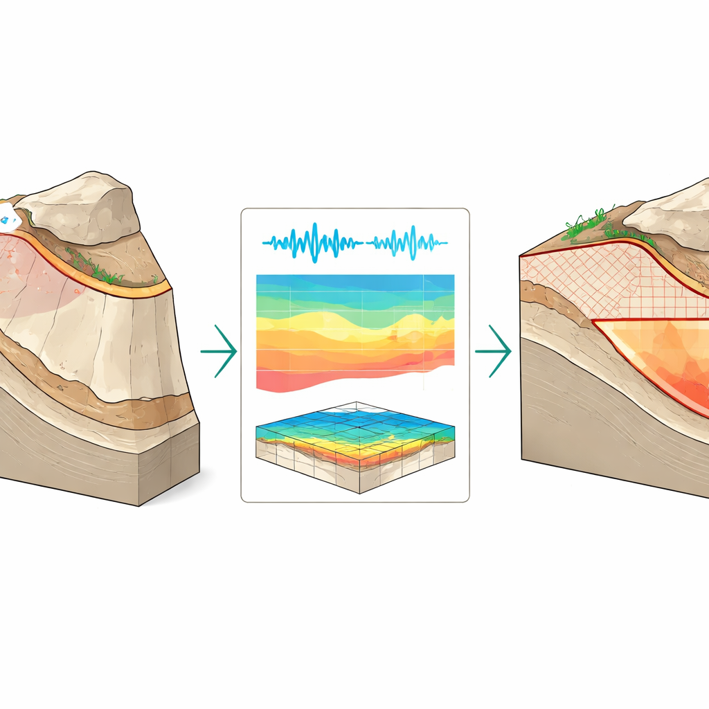
Listening to Rock Vibrations
The authors build on a different source of information: the way rock bodies naturally vibrate. Wind, waves, distant earthquakes, and human activity constantly set cliffs and rock slabs into tiny motions, much like a bell that hums after being struck. Each rock mass has its own set of resonance frequencies and vibration patterns, which depend on its shape, material, and how firmly it is attached to the surrounding ground. By placing small seismic sensors in lines across two unstable rock slabs in Utah (Courthouse Mesa) and Malta (Paradise Bay), the team recorded these ambient vibrations and used a method called operational modal analysis to extract the dominant resonance frequencies and three-dimensional patterns of motion.
Testing Thousands of Invisible Fracture Patterns
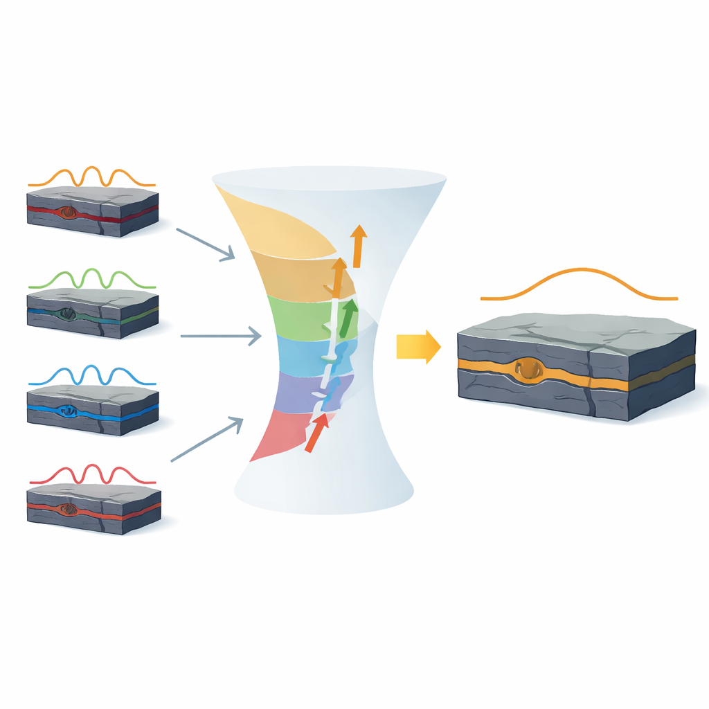
Rather than assuming a specific fracture depth or shape from field measurements, the researchers flipped the problem: if the vibrations are known, which internal fracture patterns could produce them? They created detailed three-dimensional computer models of each slab and then systematically changed the rear fracture surface that separates the unstable block from the stable plateau. A simple grid on this boundary allowed them to switch each piece between “fixed” (well attached) and “free” (effectively cracked) conditions. Guided by rules that mimic how cracks usually grow downward under gravity, they stochastically generated tens of thousands of different fracture configurations, from barely broken to almost fully detached, and computed how each one would vibrate.
Picking the Best-Matching Underground Picture
To see which simulated slopes matched reality, the team compared both the relative spacing of the resonance frequencies and the shapes of the vibration patterns with those measured in the field. They combined these into a single score that rewards models reproducing not just the tones of the “rock instrument” but also how it flexes and twists in space. Instead of searching for one perfect answer, they focused on the family of top-performing models. Where these models consistently showed free boundaries, the authors inferred zones of persistent detachment; where they disagreed, they identified areas of remaining uncertainty. At Paradise Bay, this process pointed to a well-defined deep fracture zone that agreed with limited direct depth measurements. At Courthouse Mesa, the method confirmed a partially detached slab with deeper cracking toward one end, again broadly consistent with field evidence.
What This Means for Landslide Risk
This work turns routine ground vibrations into a powerful, non-invasive tool for peering inside dangerous rock slopes. By tying measured resonance properties to computer models that explore thousands of realistic fracture patterns, the method helps reveal where large blocks are already close to being detached at depth, even when direct measurements are sparse or uncertain. While it cannot deliver a single exact map of every crack, it narrows the range of plausible structures and highlights the most likely failure surfaces. In the long run, combining this approach with repeated vibration measurements could allow engineers to track how fractures grow over time, improving landslide hazard assessments and supporting safer design and monitoring of cliffs, road cuts, and other fractured rock slopes.
Citation: Grechi, G., Moore, J.R., D’Amico, S. et al. Reconstructing subsurface fracture geometries in rock slope instabilities through ambient vibration-based numerical modelling inversion. Sci Rep 16, 8054 (2026). https://doi.org/10.1038/s41598-026-39538-9
Keywords: rock slope stability, subsurface fractures, ambient vibrations, landslide hazard, numerical modelling