Clear Sky Science · en
Land use and land cover dynamics in dryland ecosystem of Northwestern Ethiopia: taking into account uncertainties and correcting bias in satellite-based maps
Why these changing woodlands matter
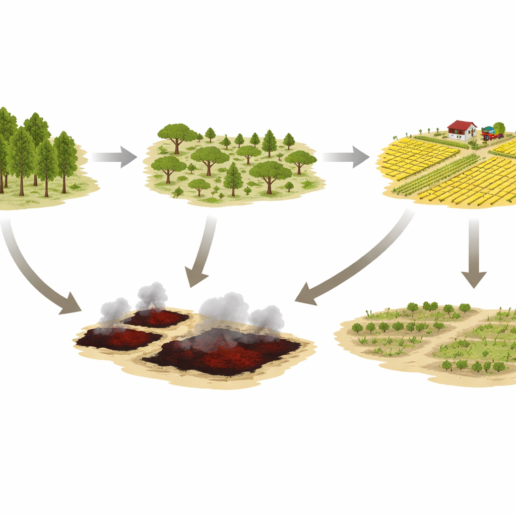
Across much of Africa’s dry lowlands, woodlands that support wildlife, store carbon, and sustain rural communities are being reshaped by farming and fire. This study zooms in on one such landscape in Northwestern Ethiopia to ask a simple but crucial question: how much of the natural land cover has really changed over the past three decades, and how sure are we about those estimates when they come from satellite images? By tracking change carefully—and correcting for hidden errors—the researchers reveal a story of rapid expansion of cropland, degradation of woodland, and frequent burning that together threaten the long‑term health of this dryland ecosystem.
Looking from space with a critical eye
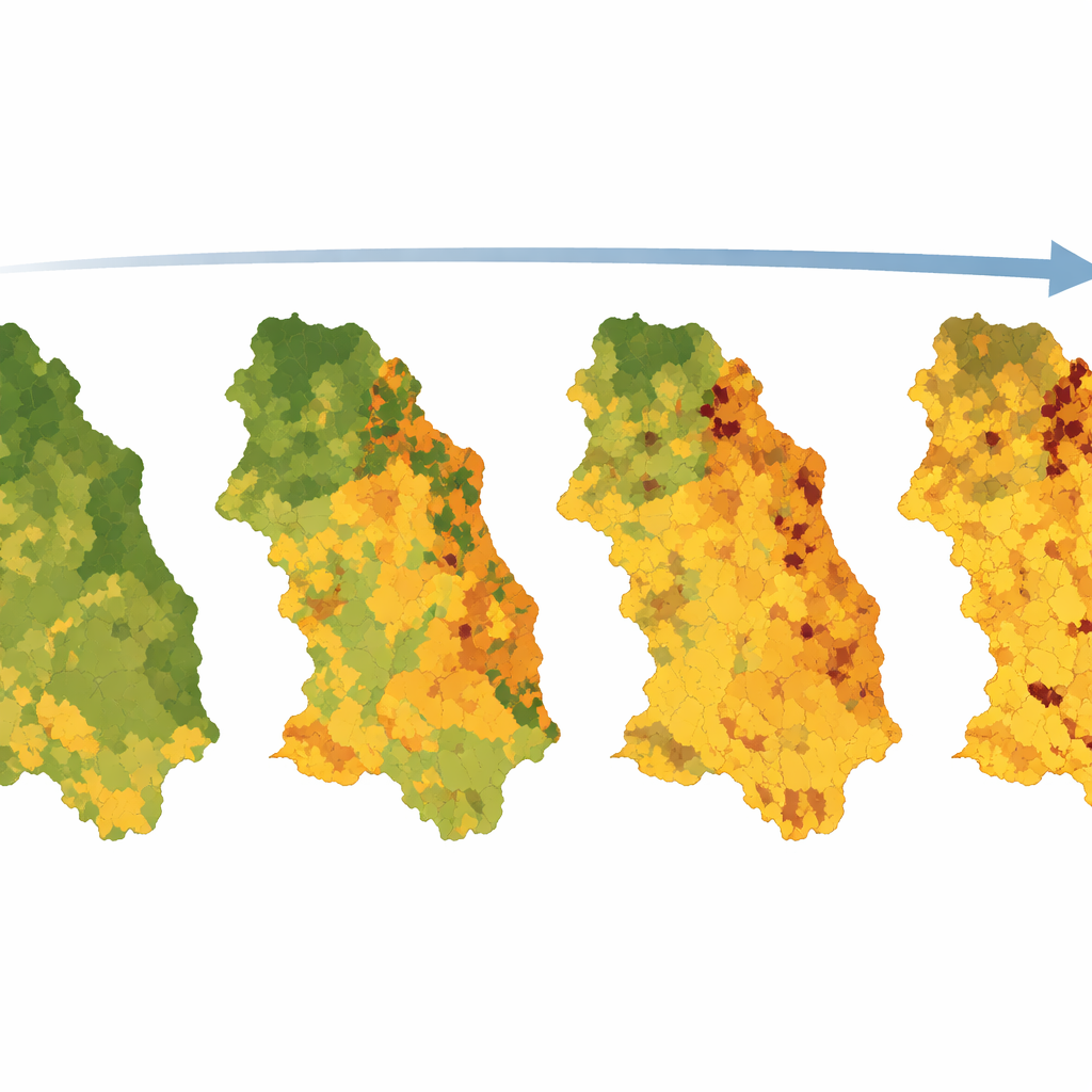
The team focused on the Metema district, a dry tropical area covered by Combretum–Terminalia woodlands and wooded grasslands. These landscapes are valuable for grazing, wood products, and climate regulation but are also prime targets for agricultural expansion and resettlement. Using freely available Landsat satellite images from 1986, 2000, 2010, and 2019, the authors classified each pixel into seven land‑cover types, including forest, woodland, other woodland (sparse trees and shrubs), grassland, cropland, burned area, and water. Instead of accepting the raw satellite classifications at face value, they combined them with detailed reference data from Google Earth, existing maps, and stable features such as church forests to check where the images were right or wrong.
Making the maps more honest
To turn these checked maps into reliable area estimates, the researchers used a machine‑learning method called random forests, which proved highly accurate for separating land‑cover types, and then applied a statistical correction to remove bias. They drew a carefully designed sample of reference points and calculated how often each mapped category matched reality on the ground. This allowed them to adjust the estimated area of each class and to quantify uncertainty—how wide the plausible range of values might be. Overall, the corrected maps were very accurate, with most land‑cover types exceeding 90% accuracy and uncertainties typically below 5%, though burned areas and small water bodies were harder to pin down. Importantly, for most classes the differences between simple pixel counts and bias‑adjusted areas were small, but for some—especially cropland and burned areas—ignoring errors would have noticeably distorted the picture.
A landscape tilting toward farms
The corrected numbers reveal a dramatic re‑shaping of Metema’s land cover between 1986 and 2019. Cropland area more than doubled, increasing by about 117%, and became the dominant land use after 2010. This expansion came largely at the expense of grasslands and woodlands: grassland cover shrank by nearly 60%, while woodland fell by about a quarter over the full 33‑year period. The most intense wave of change occurred between 1986 and 2000, when woodland and grassland were rapidly converted to cropland and to more degraded, sparsely treed land. Later, between 2000 and 2010, some of that degraded land and abandoned fields partially recovered, contributing to temporary gains in woodland and forest, but this regrowth did not fully compensate for earlier losses.
Fire, degradation, and fragile recovery
Fire emerged as a recurring disturbance that interacts with farming to shape the landscape. Burned areas were detected in every reference year, with particularly large extents around 2000 and 2019. Field observations suggest that many of these fires are human‑set, for clearing land or managing grazing, rather than purely natural events. Fire, combined with wood extraction and grazing, tends to thin out the woodland, pushing it toward shrub‑dominated or grassy states and making it easier for cropland to expand. While some abandoned fields did show signs of natural regrowth into woodland, the study found that only about a third of the landscape remained unchanged over the full study period, underscoring how pervasive human influence has become.
What this means for people and the planet
For non‑specialists, the core message is straightforward: in this corner of Ethiopia, farms have steadily replaced natural vegetation, and repeated burning is degrading what remains. By taking extra steps to correct satellite‑based maps and quantify uncertainty, the authors show that we can trust both the overall pattern and the magnitude of these changes, not just visually appealing images. Their results imply that without better land‑management strategies—such as protecting remaining woodlands, restoring degraded areas, and supporting natural regeneration of abandoned fields—the Combretum–Terminalia woodlands will continue to lose their ability to support local livelihoods and buffer climate impacts. At the same time, the study offers a blueprint for producing more reliable land‑change information anywhere in the world, information that is essential for planning conservation, tracking progress toward sustainability goals, and designing fair climate‑related payments for protecting forests.
Citation: Abich, A., Negash, M., Tarkegn, T.G. et al. Land use and land cover dynamics in dryland ecosystem of Northwestern Ethiopia: taking into account uncertainties and correcting bias in satellite-based maps. Sci Rep 16, 8924 (2026). https://doi.org/10.1038/s41598-026-39301-0
Keywords: land use change, dryland woodlands, remote sensing, cropland expansion, Ethiopia