Clear Sky Science · en
Experimental study on the three-dimensional structural characteristics of bedforms and their relationship with flow intensity
Why the shapes on a riverbed matter
If you have ever watched clear water run over a sandy bottom, you may have noticed tiny ripples and larger underwater dunes forming and slowly shifting. These patterns are not just pretty: they influence how rivers erode their beds, where sand and mud are deposited, and even how flood defenses and bridges should be designed. This study uses carefully controlled laboratory experiments and advanced 3D imaging to uncover how the shapes of these underwater sand waves change as the strength of the flowing water increases.
Building a river in the laboratory
To explore these bed shapes in detail, the researchers built a 15-meter-long glass-sided channel and filled part of it with a layer of sand. They pumped water through the flume at different slopes and flow rates until the sand bed reached a stable, repeating pattern of ripples and dunes. Instead of relying on expensive sonar equipment, they photographed the bed from many angles and used a "structure from motion" technique—similar to how some smartphone apps build 3D models—to reconstruct the riverbed surface with millimeter accuracy. This allowed them to capture more than two million data points describing the height of the sand at every spot along the bed. 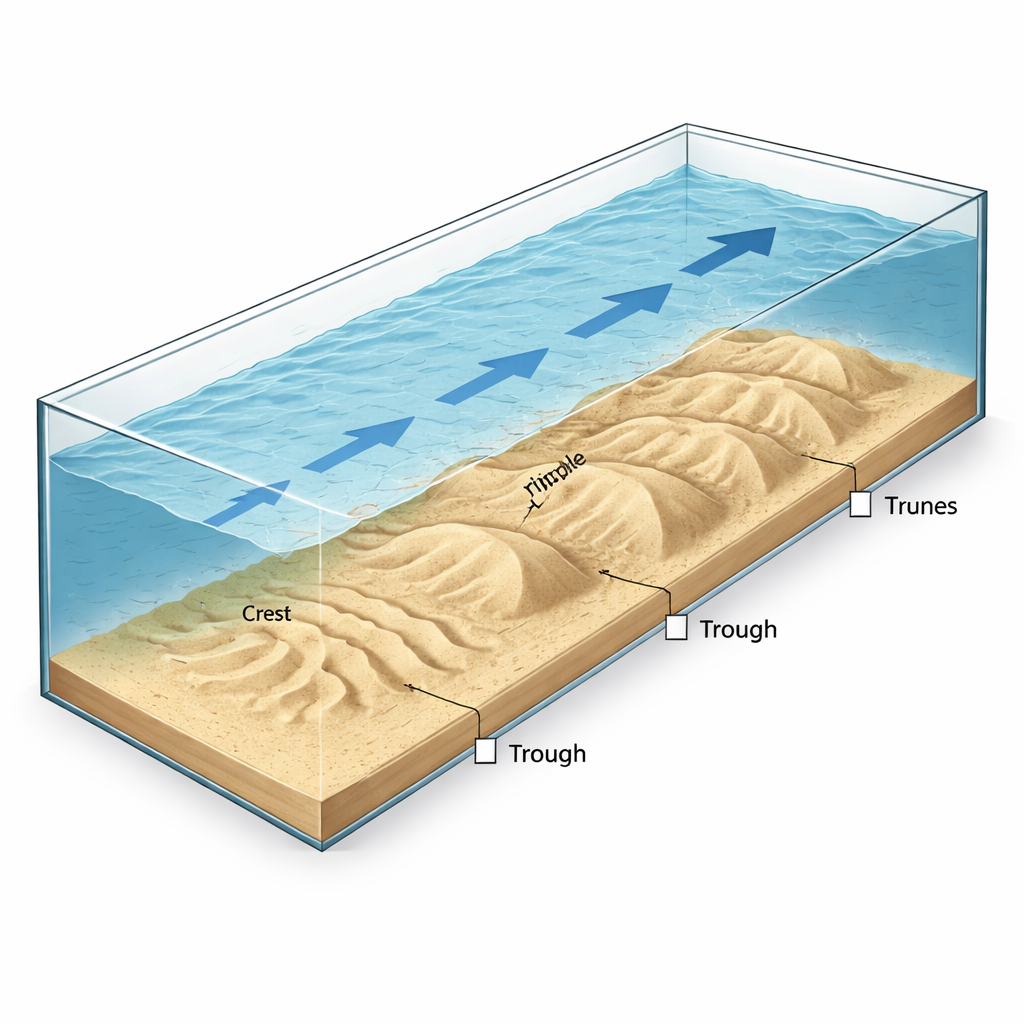
Cleaning up the signals in the sand
Raw measurements of the bed are noisy: the overall slope of the channel, small camera errors, and random bumps in the sand can all hide the true patterns of the ripples and dunes. To separate signal from noise, the team applied a mathematical tool called a wavelet transform, which effectively removes long, gentle trends and high-frequency noise while preserving the characteristic wiggles of the bedforms. After this processing, they used an automated peak-finding procedure to identify each crest and trough along hundreds of cross-sections. From these crest–trough pairs they calculated the main geometric features of every sand wave: its length (the distance between troughs), height (how far the crest rises above the troughs), overall steepness (height divided by length), and the angles of the gentle upstream slope and the steeper downstream face.
How ripples and dunes respond to changing flow
The experiments covered a range of flow strengths typical of relatively gentle river conditions. Under the weakest flows, only a few long, low ripples appeared, with large spacing between crests. As the water sped up, more dunes formed, and their spacing shrank; beyond a certain point, however, further increases in flow caused the dunes to spread out again and grow taller. This led to a non-monotonic behavior: both dune length and height first decreased, then increased as flow intensified. Statistical analysis showed that dune lengths most closely follow a gamma-shaped distribution, while heights and steepness are better described by a Weibull form, both reflecting many modest-size dunes and fewer very large ones. Strikingly, about 60 percent of the dunes had relatively low downstream slopes, with angles under 10 degrees, a shape associated with weaker, less persistent flow separation behind each dune and lower resistance to the flow. 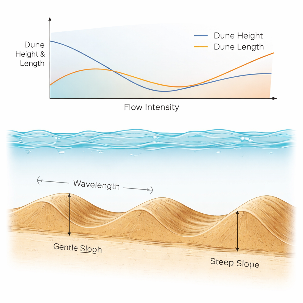
Linking underwater shapes to flow strength
To make their findings more broadly useful, the authors expressed dune size in terms of water depth and compared their results with classic formulas that engineers and geoscientists have used for decades. They confirmed that dune length and height generally scale with depth, but their small flume and shallow water limited how large the dunes could grow. When they plotted dimensionless dune height and length against a standard measure of flow strength (which compares the drag of the water to the weight of the sand grains), both scaled measures again showed the same pattern of first shrinking and then growing with stronger flow. Importantly, normalized height changed more strongly than normalized length, meaning dune height responds faster than spacing to changes in flow, and thus steepness tends to rise as the flow becomes more energetic.
What this means for real rivers
For non-specialists, the key message is that the underwater landscape of a river is dynamic and predictable in systematic ways. By combining high-resolution 3D imaging with careful statistical analysis, this work maps out how the size, spacing, and slopes of sand ripples and dunes change as water flow intensifies, especially in a range of conditions that had been poorly documented before. The results show that many widely used rules of thumb for dune size still hold under weaker flows, but that laboratory constraints can systematically shrink the observed dunes. These insights help improve models of how rivers move sand and reshape their beds over time, supporting better design of waterways, bridges, and flood defenses, and offering a clearer window into how past and future changes in flow might be recorded in layers of river sand.
Citation: Wang, H., Zhao, L., Fu, D. et al. Experimental study on the three-dimensional structural characteristics of bedforms and their relationship with flow intensity. Sci Rep 16, 7762 (2026). https://doi.org/10.1038/s41598-026-39275-z
Keywords: river bedforms, sand ripples and dunes, sediment transport, flow intensity, flume experiments