Clear Sky Science · en
Environmental evolution of a coastal lake in the Larsemann Hills, East Antarctica during the Holocene: a multi-proxy perspective
Tracing the Story of a Hidden Polar Lake
On the icy edge of East Antarctica, a small blue lake tucked just a few hundred meters from the sea holds a detailed diary of past climate change. By reading the mud at its bottom grain by grain, scientists have reconstructed how this lake gradually transformed from part of the ocean into an isolated pool of freshwater over the last six thousand years. Understanding this transformation is more than a local curiosity: it helps researchers gauge how the giant East Antarctic Ice Sheet has waxed and waned, and how future melting could raise sea level worldwide.
A Coastal Lake at the End of the World
Heart Lake lies in the Larsemann Hills, a rare ice-free oasis along the East Antarctic coast. Today it sits about five meters above sea level and roughly 200 meters from the shoreline, surrounded by rocky hills and fed by snowmelt. But its position so close to the ocean makes it especially sensitive to changes in sea level and the vertical “bounce-back” of the land after glaciers thin and retreat. When sea level is high, the basin can be flooded by the ocean; when sea level falls or the land rises, the same basin can become cut off and turn into a lake. That makes Heart Lake an ideal natural gauge for how ice, ocean, and land have interacted during the Holocene, the relatively warm period since the last ice age.
Reading Ancient Climates in Mud and Microbes
To piece together this history, the team extracted a meter-long cylinder of sediment from the lake bottom. Each layer in this core represents a slice of time, with the oldest at the bottom and the youngest at the top. They dated the layers using radiocarbon and then examined them with a suite of tools. Microscopic algae called diatoms revealed whether the water was salty or fresh at different times. Measurements of magnetic minerals tracked how much rock material was being delivered by glaciers, wind, or waves. Chemical fingerprints of the sediments showed how strongly the surrounding rocks were being broken down, which in turn reflects whether the climate was cold and dry or relatively warm and wet. Together, these independent clues form a “multi-proxy” view of environmental change.
From Seafloor to Lake Shore
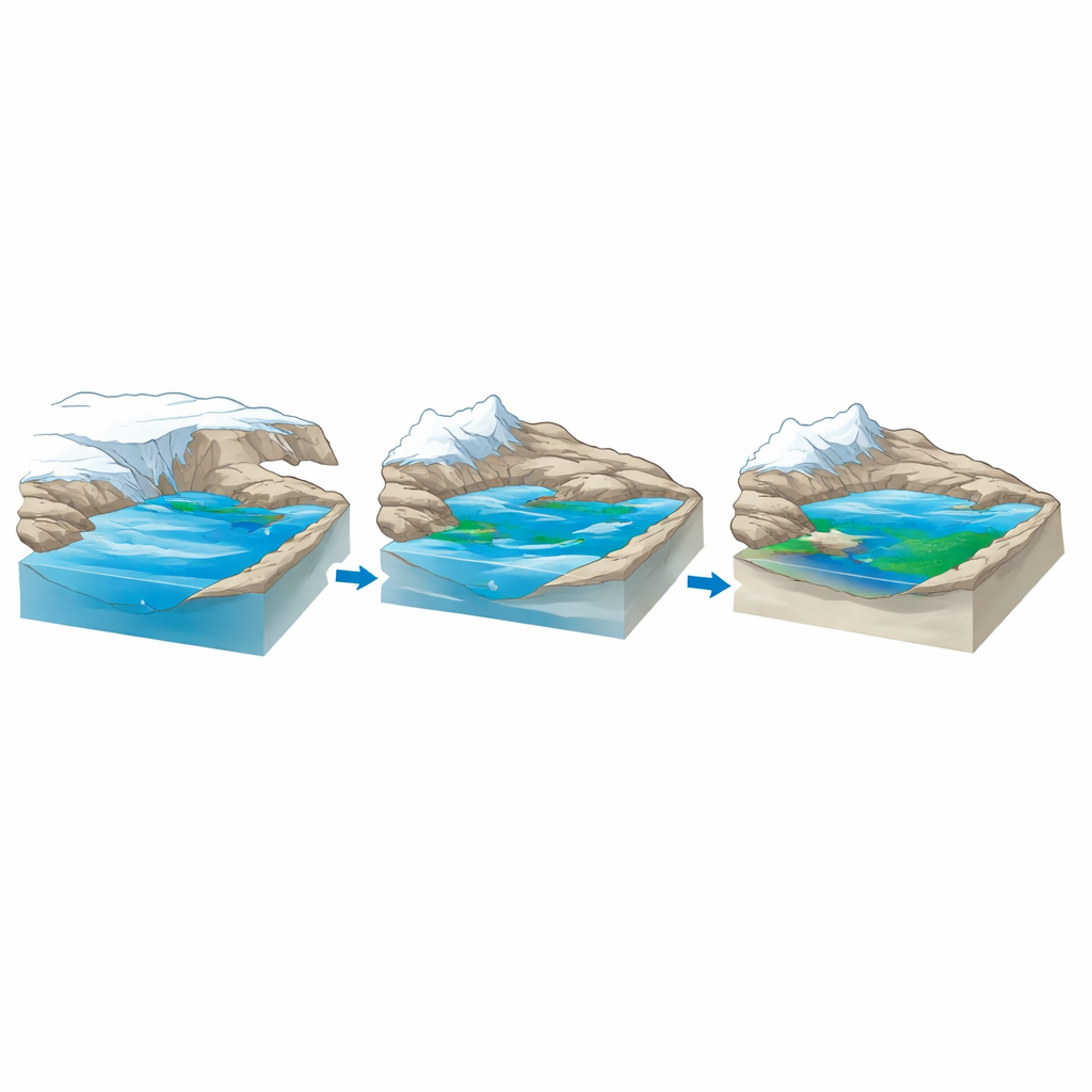
The core reveals three main phases in Heart Lake’s life. For much of the period from about 6,400 to 3,100 years ago, the basin lay below sea level and functioned as part of the ocean floor. Marine and sea-ice diatoms dominate these older layers, and the sediments contain abundant coarse, magnetically strong grains likely delivered by nearby glaciers and coastal currents. Around 4,300 years ago, the chemical signs of rock weathering begin to rise, pointing to somewhat warmer and possibly wetter conditions that exposed more bedrock to the elements. Then, about 3,100 years ago, the first freshwater diatoms appear, and the sediment becomes a mix of marine and freshwater signals. During this long transition, sea level and the height of the land were closely matched, so the basin alternated between sharing water with the ocean and behaving like a shallow lake.
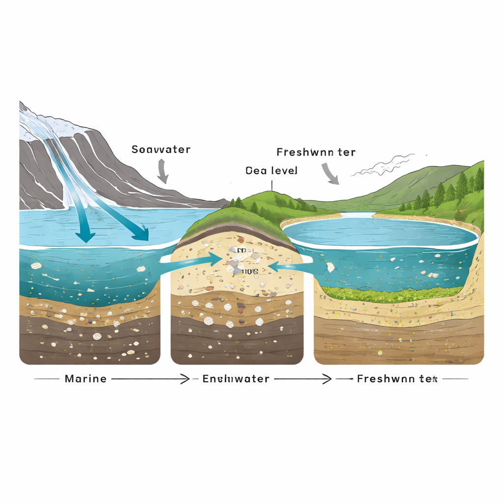
A Lake Breaks Free from the Sea
By roughly 1,750 years ago, the lake completed its separation from the ocean. From this point upward in the core, only freshwater diatoms are found, the supply of coarse marine and glacial material drops, and the degree of chemical weathering in the surrounding rocks increases further. The lake became a fully isolated freshwater system, with thin layers rich in organic matter and cyanobacterial mats carpeting the bottom. Subtle shifts in the magnetic and wind-blown dust record toward the very top of the core hint at a later cooling episode, likely related to the centuries-long cold spell known as the Little Ice Age, although the resolution is too low to trace all of its details.
What This Polar Time Capsule Tells Us
To a non-specialist, Heart Lake’s story may sound like a niche Antarctic puzzle, but it offers a powerful lesson. The gradual shift from a submarine basin to an isolated lake records how the land has risen as the heavy ice sheet thinned, and how regional sea level has changed through time. These slow adjustments, driven by the balance between global sea-level rise and the rebound of Earth’s crust, are the same processes that will shape future coastlines as modern ice sheets respond to warming. By combining tiny fossils, magnetic grains, and chemical markers, this study shows how a seemingly modest lake can preserve a rich, layered history of ice, ocean, and climate—and helps refine our understanding of how sensitive Antarctica is to shifts in the planet’s climate system.
Citation: Joju, G.S., Warrier, A.K., Mahesh, B.S. et al. Environmental evolution of a coastal lake in the Larsemann Hills, East Antarctica during the Holocene: a multi-proxy perspective. Sci Rep 16, 9139 (2026). https://doi.org/10.1038/s41598-026-39218-8
Keywords: East Antarctica, Holocene climate, coastal lake, relative sea level, paleoenvironments