Clear Sky Science · en
A method for compiling satellite image map geographic objects based on vector map data via deep learning
Why changing what maps show matters
Online maps often feel like windows onto the real world, but what you see from above is carefully designed. Satellite image maps are valued because they look like real places, yet sometimes we need to hide sensitive facilities, clean up cluttered scenes, or make sure different kinds of maps agree with each other. This paper presents a new way to automatically "edit" satellite images using artificial intelligence, so that buildings and roads can be removed, added, shifted, or reshaped while the picture still looks natural and convincing. 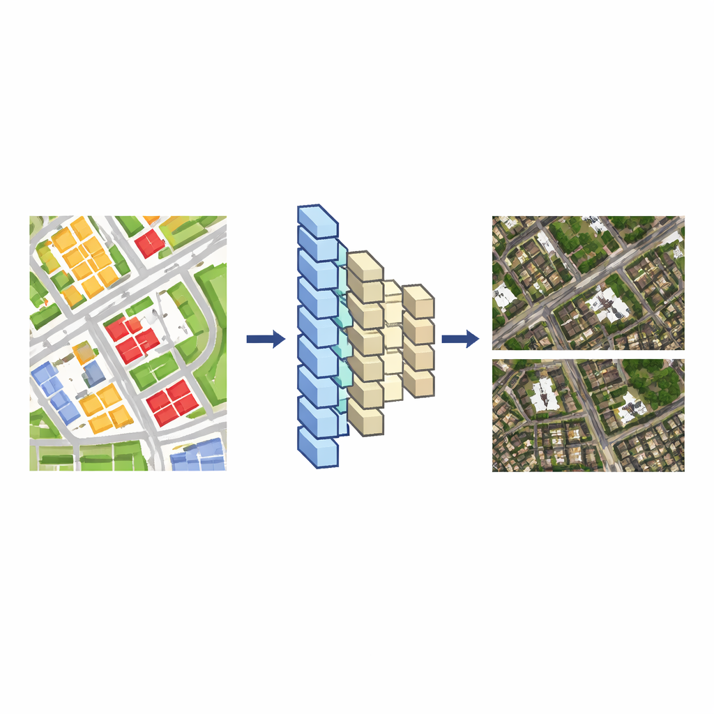
From simple drawings to realistic views
Modern map systems usually hold two kinds of geographic data. One is the satellite image itself, a dense patchwork of pixels. The other is a vector map, a cleaner drawing made of lines and shapes that mark roads, buildings, rivers, and more. Editing the vector map is relatively easy, but changing the matching satellite image by hand is slow and painstaking, because every building’s pixels blend into shadows, trees, and nearby structures. The authors’ key idea is to teach a deep learning model to translate from these vector drawings into realistic satellite images. Once the model has learned this link, any change made to the vector map can be turned automatically into a consistent change in the satellite view.
Teaching an AI to imagine cities
To build this translator, the researchers start with areas where a vector map and a satellite image cover the same region at a similar scale. They cut both into many small tiles, pairing each vector tile with its corresponding image tile, and use these pairs as training data. An encoder–decoder neural network—similar to tools used for image-to-image translation—learns how the arrangement of colored blocks and lines in the vector tile relates to roofs, streets, and vegetation in the satellite tile. They compare two popular network designs, UNet++ and Pix2Pix, and find that Pix2Pix produces satellite-like images that more closely match reality and trains reliably, so it becomes their base model.
Focusing the model on places to change
Simply learning from the whole city is not enough when you want to tweak specific objects cleanly. To sharpen the model’s skill around target areas, the authors use transfer learning. They extract extra training tiles that surround the buildings or roads they plan to edit and run a short additional training phase using only these local examples. This fine-tuning step greatly improves how well the model reproduces those neighborhoods, making later edits look sharper and more precise. 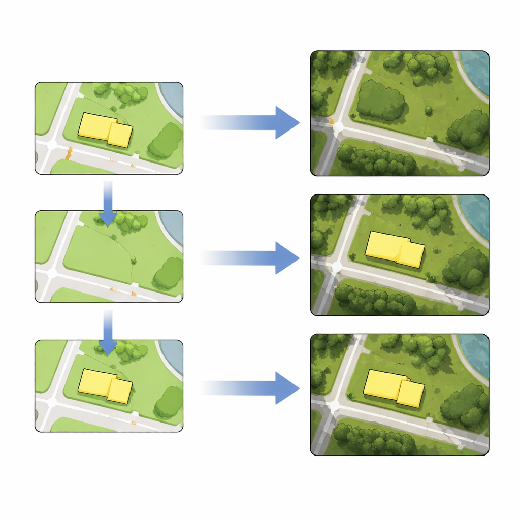
Editing buildings and roads like map layers
With the tuned model in place, compiling satellite image maps becomes a three-step recipe. First, a cartographer edits the vector map: deleting a building, drawing a new road, reshaping a block, or moving an object to a new position. Second, the edited tiles from the vector map are fed into the trained network, which generates new satellite tiles that reflect the intended change while preserving surrounding detail and texture. Third, these generated tiles replace the original image tiles. Using real data from Berlin, the authors demonstrate all four operations—deletion, insertion, distortion, and displacement—for both building footprints and road lines, either one by one or in batches. Measurements show that the positions of edited objects in the generated images differ from their vector counterparts by only a few pixels, an accuracy acceptable for many mapping tasks.
What this means for future maps
In plain terms, the study shows that once an AI has learned how vector maps and satellite images correspond, you can edit the simple drawing and let the model repaint a believable aerial view to match. This opens the door to satellite image maps that can be tailored: hiding sensitive sites, clarifying complex scenes, or blending real and imagined spaces such as game worlds and virtual environments. At the same time, it highlights the power—and risk—of "deepfake" geography, where realistic-looking aerial images may no longer be straightforward photographs of the world as it is.
Citation: Du, J., Zeng, D., Cai, K. et al. A method for compiling satellite image map geographic objects based on vector map data via deep learning. Sci Rep 16, 9295 (2026). https://doi.org/10.1038/s41598-026-39096-0
Keywords: satellite imagery, deep learning, map editing, remote sensing, deepfake cartography