Clear Sky Science · en
Forecasting land-use and land-cover change for groundwater sustainability in the Muvattupuzha basin using CA-Markov (2033–2050)
Why changing land matters for hidden water
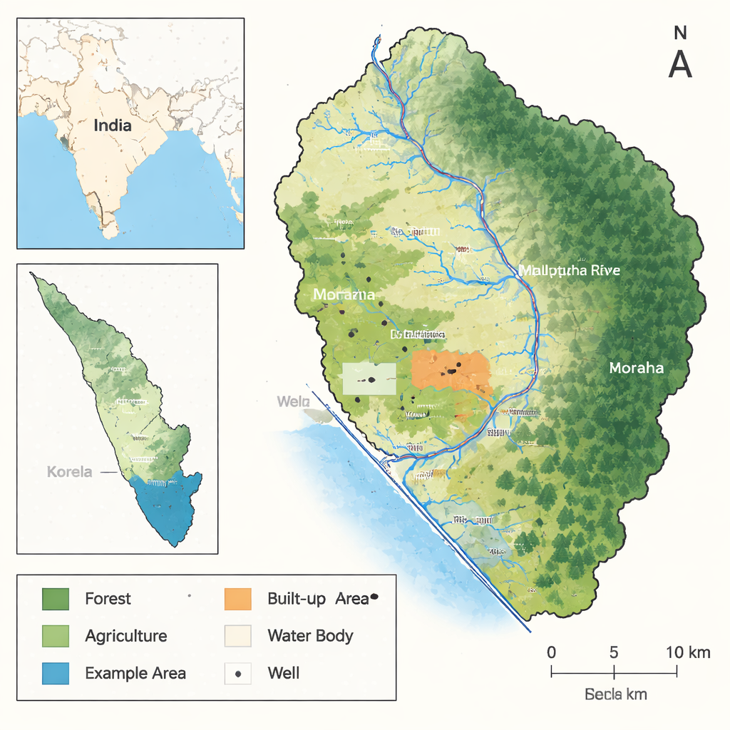
In many tropical regions, millions of people draw their drinking water from underground. Yet the way we build cities, clear forests, and farm the land quietly reshapes this hidden resource. This study looks at Kerala’s Muvattupuzha River Basin in southern India to ask a pressing question: as the landscape urbanizes, what happens to the quality and reliability of the groundwater that residents depend on?
A river basin under rapid human transformation
The Muvattupuzha Basin stretches from steep, forested hills in the Western Ghats down to low-lying paddy fields and backwaters near the Arabian Sea. Using satellite images from 2003, 2013, and 2023, the researchers tracked how land use and land cover changed over two decades. Forest and farmland once dominated the basin, but built-up areas – towns, villages, roads, and other paved surfaces – expanded dramatically. Built-up land grew from about 12% of the basin area in 2003 to more than 44% in 2023, mostly by replacing agricultural land and parts of the vegetated landscape. At the same time, the amount of truly vacant or barren land shrank, and water bodies and wetlands showed only minor overall changes, despite local encroachment and reclamation.
Peering underground: how water chemistry is shifting
To see how these surface changes affect what is happening below ground, the team analyzed groundwater data from wells across the basin for three benchmark years: 2003, 2013, and 2023. They measured basic properties such as electrical conductivity (a sign of how salty or mineral-rich the water is), dissolved solids, major dissolved minerals like calcium, magnesium, and sodium, and nitrate, which often comes from fertilizers and sewage. Over time, many wells showed a steady rise in dissolved minerals and hardness, pointing to increasing mineralization of the aquifer. Nitrate levels also climbed in several locations, especially near urban and intensively farmed areas, signaling growing influence from human waste and agricultural chemicals. While many wells still fell within drinking-water guidelines, a pattern of gradual decline in overall quality emerged.
From maps and statistics to future scenarios
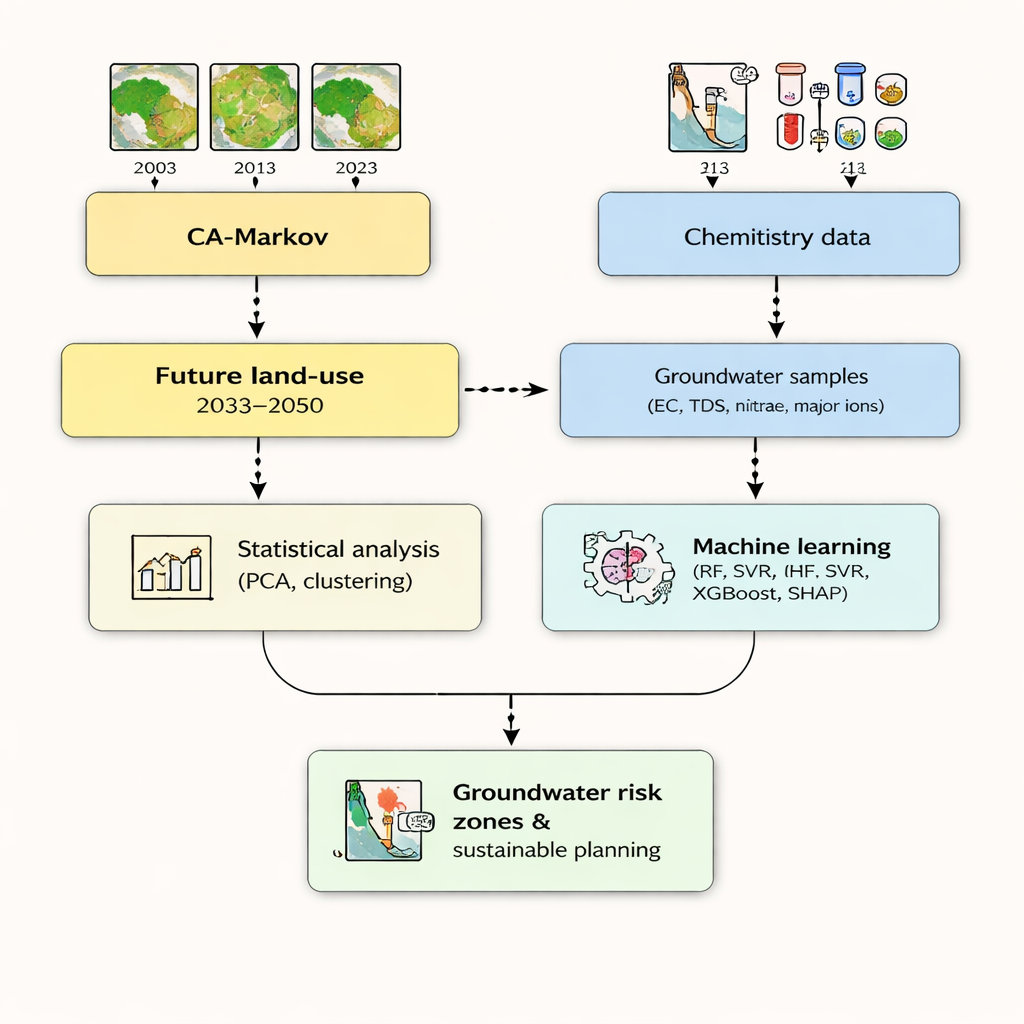
Understanding trends is not enough; planners need to know what might happen next. The researchers used a technique called CA-Markov modeling to project how land use might evolve from 2023 to 2050, based on observed changes and physical constraints such as slope, elevation, soils, and distance to roads and rivers. Their simulations suggest that built-up areas will continue to spread through 2033 and 2043 before growth slows toward 2050, while agricultural land and surface water areas face continued pressure. In parallel, the team applied multivariate statistics to the groundwater data to tease apart two main forces shaping water quality: natural processes that dissolve minerals from rocks, and human activities that add pollutants at the surface. This analysis showed that salty, mineral-rich water and nitrate contamination often followed different patterns, hinting at distinct underlying causes.
Machine learning to unpack invisible risks
The study went a step further by using machine learning algorithms to see whether nitrate – a health-relevant pollutant – could be predicted from other, easier-to-measure water properties. Models such as Random Forest, Support Vector Regression, and XGBoost were trained on the well data, and an “explainable AI” tool called SHAP was used to reveal which factors mattered most. The models pointed to magnesium, calcium, and alkalinity as key influences on nitrate levels, likely reflecting how natural buffering reactions and oxygen conditions in the aquifer encourage or suppress nitrate build-up. At the same time, the limited predictability of nitrate from general water chemistry alone underscored that local land uses, sanitation, and farming practices remain crucial drivers that must be monitored directly.
What this means for people and planning
For residents and decision-makers, the message is clear: the way land is used in the Muvattupuzha Basin strongly shapes the quality of the groundwater below. Rapid urban growth, coupled with changing agriculture, has already increased mineral content and nitrate in many wells, and projected land-use trends suggest continued stress if current patterns persist. By combining satellite-based land maps, field measurements, and transparent machine learning tools, the study offers a practical framework for spotting emerging groundwater “hotspots,” guiding where to protect recharge areas, improve sewage and fertilizer management, and steer future development. In simple terms, smart land planning today can help keep tomorrow’s wells cleaner, safer, and more reliable.
Citation: K, A., Gautam, S., Prince Arulraj, G. et al. Forecasting land-use and land-cover change for groundwater sustainability in the Muvattupuzha basin using CA-Markov (2033–2050). Sci Rep 16, 7462 (2026). https://doi.org/10.1038/s41598-026-38961-2
Keywords: groundwater, urbanization, land use change, nitrate pollution, Kerala