Clear Sky Science · en
Integrated fractal clustering and inversion of induced polarization data for concealed gold exploration in Kabudan area NE Iran
Finding Hidden Gold Beneath a Quiet Landscape
In parts of northeastern Iran, the ground gives no obvious hint that valuable gold lies below. There are few outcrops, no glittering veins at the surface, and the usual exploration tools struggle to see through the complex geology. This study shows how scientists can still “see the unseen” by combining sensitive electrical measurements with a mathematical lens called fractal analysis. Together, these tools help sort faint signals from noise, guiding drillers much more precisely to buried gold-bearing rocks.
Listening to the Earth with Electricity
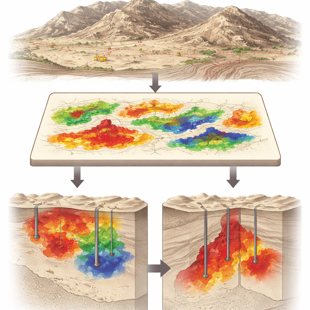
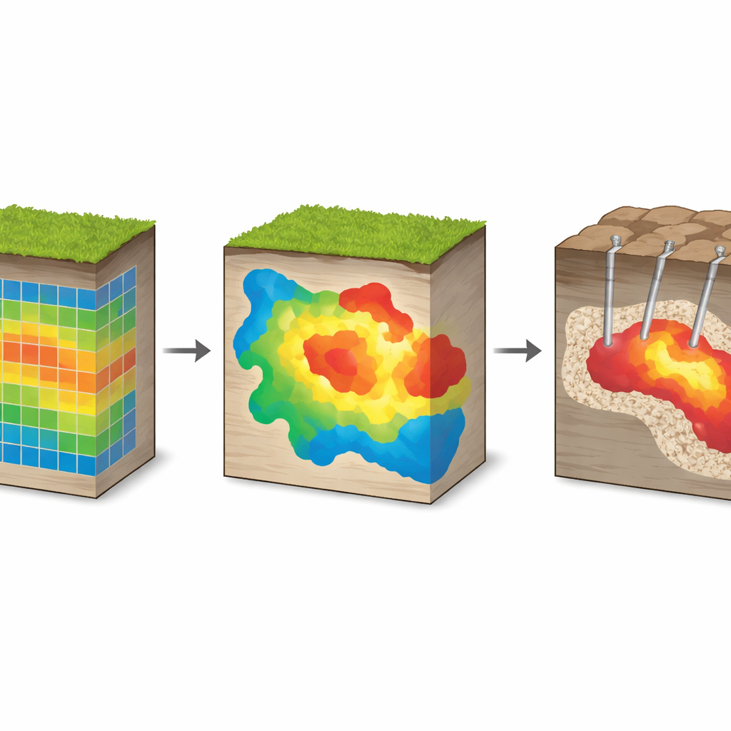
Instead of digging blindly, geophysicists send tiny bursts of electric current into the ground and watch how the earth responds. Two key properties are measured: resistivity, which shows how easily current flows, and chargeability, which shows how strongly rocks temporarily hold electrical charge. Sulfide-rich rocks that often host gold tend to stand out as especially chargeable. In the Kabudan area north of Bardaskan, where there are almost no surface clues, the team laid out large rectangular survey lines, measured these properties, and built maps of how chargeability varies from place to place.
Letting Patterns Reveal Themselves
The challenge is that real-world data are messy. Subtle mineralized zones can be smeared out or hidden when conventional mapping smooths everything together. Here the researchers turned to fractal analysis, a way of describing complex patterns that repeat across scales. They treated the chargeability values much like a satellite image and asked: which parts of this image belong to the same “family” of behavior, and which stand apart as truly unusual? Using four related fractal models, they automatically grouped the data into classes, separating ordinary background rocks from suspiciously chargeable patches that might host ore.
Choosing the Sharpest Lens
Not all pattern-finding methods perform equally well. To avoid simply trusting appearances, the authors tested each fractal model with four independent statistical checks that score how cleanly the data fall into clusters. One method, called the concentration–perimeter model, consistently produced the tightest, most distinct groups and the most stable boundaries between them. On maps, this approach drew crisp outlines around chargeable zones, suggesting likely mineralized bodies rather than scattered patches of noise. These outlined zones then guided where to collect more detailed electrical profiles in vertical cross-sections.
From Maps to Drill Cores
Electrical cross-sections and computer inversion were used to turn the surface measurements into pictures of the subsurface. Beneath the high-priority clusters, the models revealed continuous, deep-reaching chargeable bodies that looked like buried lenses of sulfide minerals. The ultimate test came from drilling. Boreholes placed into the strongest anomalies cut through rocks rich in pyrite, chalcopyrite, and magnetite, with gold grades reaching up to 8 parts per million—high for this type of deposit. Nearby holes outside the main anomaly encountered much lower gold content, confirming the targeting power of the integrated approach.
Smarter Maps for Future Gold Hunts
For a non-specialist, the key message is that the authors have built a smarter way to turn fuzzy underground signals into actionable maps. By combining fractal clustering, rigorous statistical checks, and advanced electrical imaging, they could pick out the most promising hidden zones and verify them with drill cores. The method reduced guesswork, cut the risk of drilling in the wrong place, and offers a template that can be adapted to other metals and other terrains where the geology is complex and the clues are buried. In essence, it is a new, more reliable way to find gold where the surface seems completely ordinary.
Citation: Sadatian Jouybari, S.M., Afshar, A., Ramazi, H. et al. Integrated fractal clustering and inversion of induced polarization data for concealed gold exploration in Kabudan area NE Iran. Sci Rep 16, 8432 (2026). https://doi.org/10.1038/s41598-026-38850-8
Keywords: gold exploration, geophysical imaging, induced polarization, fractal analysis, mineral deposits