Clear Sky Science · en
Spatiotemporal evolution of crustal strains preceding destructive earthquakes using GNSS
Watching the Ground Breathe Before a Quake
Imagine if we could see the Earth’s crust slowly tightening and relaxing in the years before a major earthquake, the way a doctor watches a patient’s vital signs. This study asks whether subtle changes in the shape of the ground—measured with satellite-based positioning—can reveal reliable warning patterns before destructive earthquakes like the 2024 Noto Peninsula event in Japan. By turning long-term GPS-like measurements into maps of how the crust is stretching and squeezing, the authors explore whether earthquakes leave telltale signatures in the land before they strike.
How Tiny Motions Reveal Hidden Stress
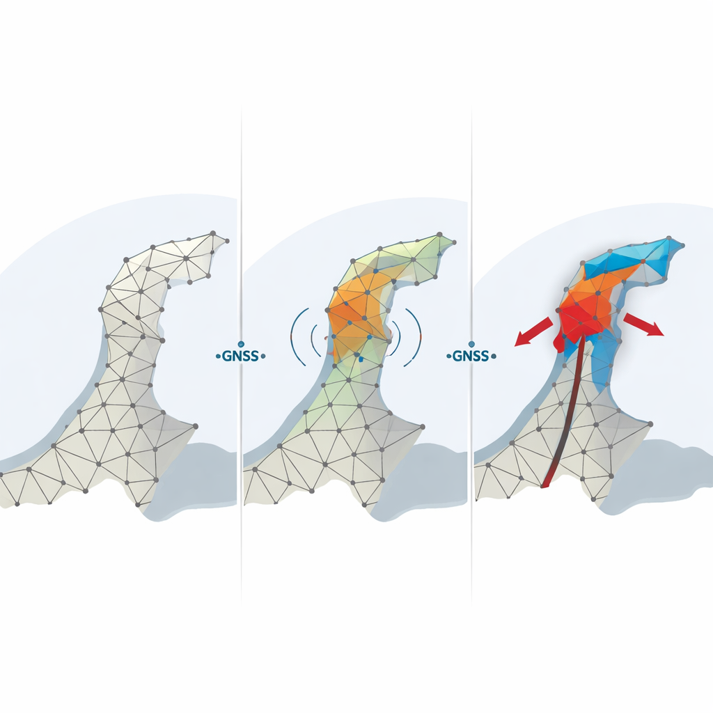
Modern navigation satellites allow scientists to pinpoint ground stations to within a few millimeters. Japan has built one of the world’s densest such networks, called GEONET, with more than a thousand Global Navigation Satellite System (GNSS) stations spread across the country. Instead of just tracking how each station moves, this study looks at how groups of stations move relative to one another. By connecting nearby stations into triangular nets and applying a method engineers use for bridges and buildings, the team converts daily position changes into “crustal strains” – measures of how much the ground surface is being stretched, squeezed, or sheared.
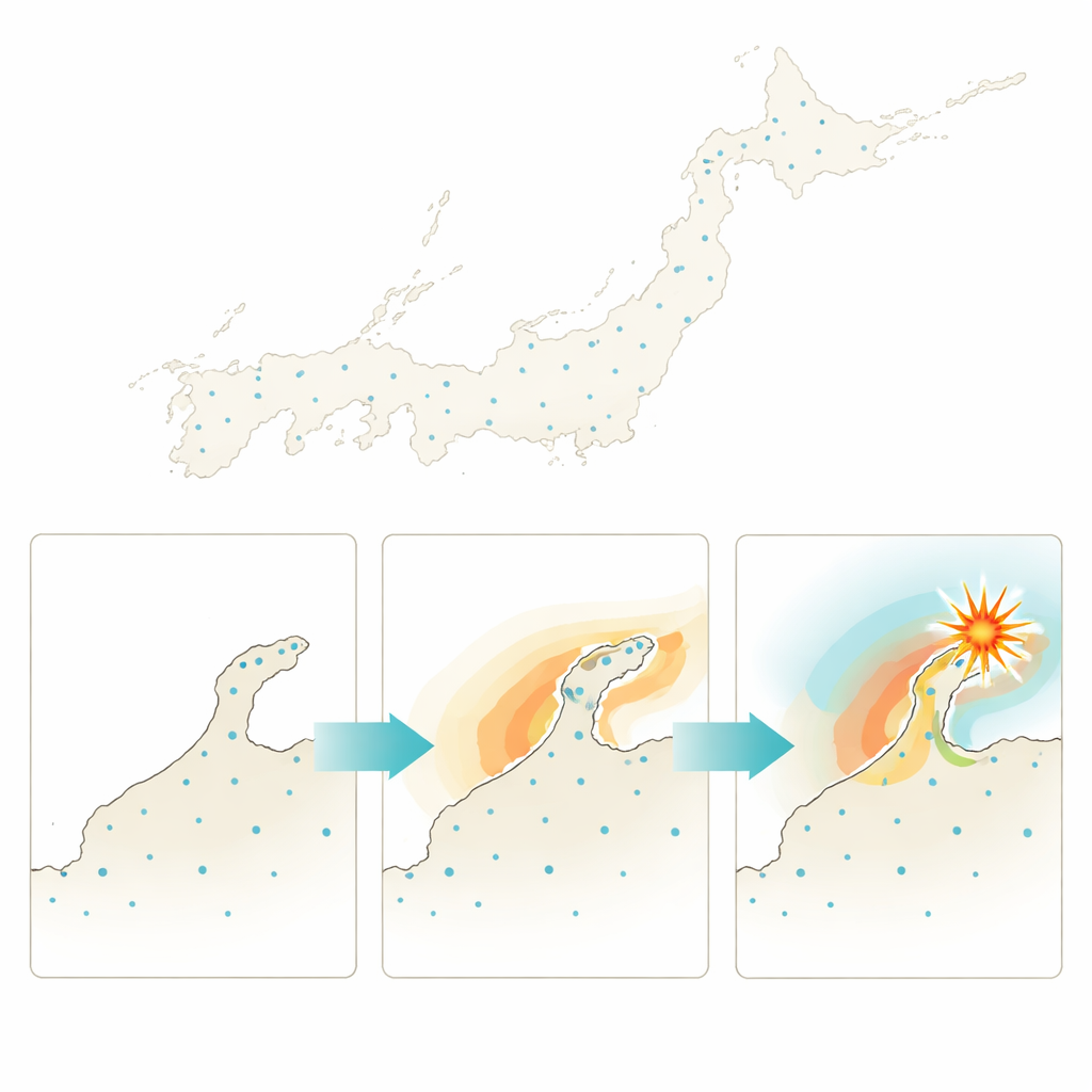
A Closer Look at the Noto Peninsula Quake
The researchers focused on three damaging Japanese earthquakes from the past decade, with special attention to the magnitude 7.5 Noto Peninsula earthquake that struck on January 1, 2024. Around the epicenter, they built a web of triangles linking GEONET stations and tracked how strain evolved day by day for roughly 13 years leading up to the event. Ordinary ground displacements—how far each station moved east, west, north, south, or up and down—looked mostly smooth and unremarkable. Even as local seismic activity picked up after late 2020, the displacement curves gave little sign that a major rupture was on the way.
Seeing Warning Signs in Expansion and Squeezing
Strain told a very different story. The team zoomed in on a particular kind of strain known as dilatation, which describes how much the surface area is expanding or contracting. Beginning around December 2020, triangular regions near the eventual Noto epicenter showed a slow, persistent change in dilatation that lasted several years. Some areas steadily expanded, others steadily contracted, forming a distinct spatial pattern that grew strongest closest to the future fault. By fitting straight lines to these multi-year trends, the researchers found that regions with the largest changes in dilatation lined up with the later rupture area and roughly matched the final deformation pattern seen when the quake hit. This suggests that the location and overall size of the impending earthquake were encoded in the evolving strain field.
Short-Term Flickers Before the Break
Beyond the slow background trend, the authors examined how “noisy” the dilatation signal became over time. They compared each day’s value with a weekly moving average and tracked how large the deviations were. For years, these fluctuations behaved in a fairly regular, seasonally dependent way, with somewhat livelier behavior in summer. But in 2023, the year before the Noto mainshock, the deviations grew unusually large around two key events: a magnitude 6.5 foreshock in May and the magnitude 7.5 mainshock on New Year’s Day. In the weeks before both earthquakes, the scatter in dilatation grew well above its long-term statistical range, especially in elements closest to the epicenter, hinting at a short-term “rattling” of the crust as it approached failure.
Clues from Other Recent Disasters
To test whether Noto was unique, the study compared the Noto strain history to that of two other destructive events: the 2016 Kumamoto and 2018 Hokkaido Eastern Iburi earthquakes. Each occurred in a different tectonic setting and at a different depth, yet all showed a years-long, earthquake-specific build-up in dilatation strain near the eventual rupture zone. The duration and style of the gradual increase appeared to scale with earthquake size, suggesting that large events may be preceded by longer episodes of slow deformation. Differences between regions that did and did not host major earthquakes further reinforced the idea that these patterns are not just background noise.
What This Could Mean for Future Warnings
For non-specialists, the key takeaway is that the ground in Japan did not simply snap without warning when the Noto Peninsula earthquake struck. Instead, the crust in that area appears to have been slowly deforming in a distinctive way for several years, and its day-to-day fluctuations grew unusually restless in the weeks before the largest shocks. While this is not a recipe for pinpoint, short-term prediction, it suggests that carefully monitoring crustal strain—especially dilatation—over wide regions could help identify where major earthquakes are becoming more likely, how big they might be, and perhaps when the crust is entering a higher-risk window. The study argues that with dense GNSS networks and refined strain analysis, earthquake science may edge closer to practical early-warning tools grounded in how the Earth’s surface quietly “breathes” before it breaks.
Citation: Kamiyama, M., Mikami, A., Sawada, Y. et al. Spatiotemporal evolution of crustal strains preceding destructive earthquakes using GNSS. Sci Rep 16, 9708 (2026). https://doi.org/10.1038/s41598-026-38681-7
Keywords: earthquake precursors, GNSS monitoring, crustal strain, Noto Peninsula earthquake, slow-slip deformation