Clear Sky Science · en
Remote sensing and GIS-based modelling of land use dynamics and urban flood risk in Lagos megacity for future flood mitigation
Why Flooded Cities Matter to Everyone
Across the world’s big cities, heavy rain that once soaked quietly into soil is now racing off concrete and flooding homes, roads, and businesses. This study focuses on Lagos, Nigeria—one of Africa’s fastest-growing megacities—to show how unchecked building over wetlands, forests, and waterways is driving more dangerous floods today and could make future storms far worse. Using satellites, computer models, and decades of data, the researchers trace how the city has transformed and what that means for people living in harm’s way.
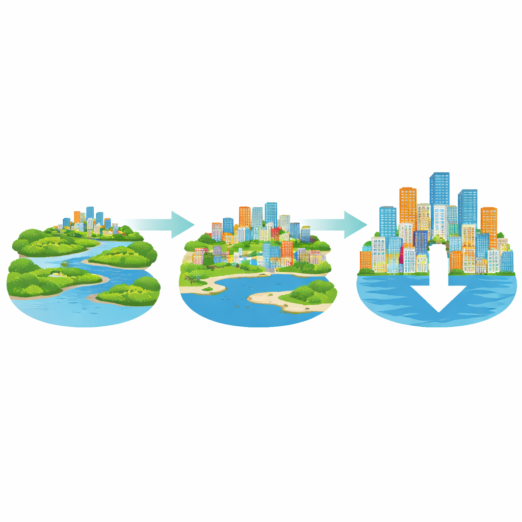
How the City Has Changed Over 40 Years
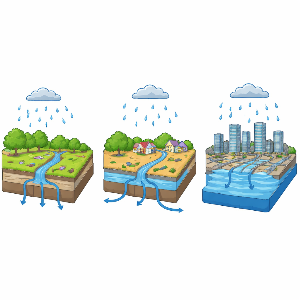
The authors first mapped how land in Lagos has been used and covered from 1984 to 2023. They grouped the landscape into six simple types: built-up areas (buildings and roads), forest, light vegetation such as grassland, bare ground, wetlands, and open water. Satellite images show a dramatic makeover. Built-up zones more than tripled, from about 15% to over half of the entire area, while forest and water bodies shrank sharply. Forest cover dropped by about a third, and water surfaces also declined, meaning the city lost large natural sponges that once slowed and stored stormwater. At the same time, lighter vegetation expanded mostly as secondary growth or scattered greenery within an increasingly urban fabric, offering only limited relief.
Measuring Where the Water Goes
Next, the team asked: when it rains hard, where does the water actually go? To answer this, they combined rainfall records, river flow data, and detailed elevation maps with a standard flood model known as HEC-HMS. They divided Lagos into several drainage sub-basins and simulated how storms in June and September—typically the wettest months—translate into runoff, stream flow, and flood depth. Because so much of Lagos is now covered in concrete and asphalt, the land absorbs little water. In many sub-basins, more than 85% of the surface behaves as “impervious,” so rainfall is quickly converted into fast-moving runoff. The model’s performance was checked against real river measurements and showed good agreement, giving confidence that the simulated flood patterns are realistic.
From Short-Lived Puddles to Month-Long Floods
Using the model, the researchers mapped three levels of flooding: low, moderate, and high. Under low-level conditions, brief floods can affect tens of thousands of hectares but usually recede within half a day, more like nuisance events. Moderate flooding, lasting up to 24 hours, covers larger areas and begins to disrupt transport, services, and daily life. The most worrying scenario is high flooding, in which water lingers for up to 30 days and inundates more than 200,000 hectares. In that case, much of Lagos’s low-lying coast and lagoon-front neighborhoods stay underwater long enough to damage homes, roads, and basic infrastructure. These patterns line up with reports from emergency agencies about where buildings and roads are repeatedly hit by floods, especially in densely populated districts such as Lagos Island, Eti-Osa, and Ajeromi/Ifelodun.
Peering Into Lagos’s Flooded Future
To look ahead, the study used a Markov chain model—a tool that projects how today’s land patterns are likely to evolve if current trends continue. Based on the observed shifts between 1984, 2002, and 2023, the model predicts land use in 2050 and then feeds that into the flood simulations. The result is sobering: by mid-century, built-up areas are expected to occupy about two-thirds of the land, while forests, wetlands, and open water shrink even further. In the extreme flood scenario for 2050, roughly three-quarters of Lagos’s land area could be affected, with built-up districts taking the brunt of the impact. Natural buffers that once soaked up and slowed water—mangroves, wetlands, and wooded zones—are too diminished to protect the growing city. Poorer residents, who often live in informal settlements on the lowest, cheapest land, are especially exposed.
What This Means for Safer Cities
For non-specialists, the message is clear: the way cities grow can either invite floods in or keep them at bay. In Lagos, decades of rapid, poorly controlled expansion have turned forests, wetlands, and waterways into hard surfaces that shed water rather than hold it. The study shows that combining satellite monitoring, computer models, and future scenarios can give planners a powerful early-warning system—pinpointing where flood risks are rising and why. Its authors argue that Lagos, and other coastal megacities like it, must urgently protect remaining natural buffers, restore degraded wetlands, enforce smarter zoning, and invest in drainage and green infrastructure. Without such steps, heavy rains that are already becoming more intense with climate change will increasingly turn into long-lasting, citywide disasters rather than manageable storms.
Citation: Aniramu, O., Iyanda, O. & Orimoogunje, O. Remote sensing and GIS-based modelling of land use dynamics and urban flood risk in Lagos megacity for future flood mitigation. Sci Rep 16, 8125 (2026). https://doi.org/10.1038/s41598-026-38544-1
Keywords: urban flooding, Lagos megacity, land use change, remote sensing, flood mitigation