Clear Sky Science · en
Evaluating flood peak attenuation effectiveness of levee management strategies in braided river reaches: a case study of the lower Yellow River
Why this river story matters
The lower Yellow River in China is famous for both nourishing millions of people and causing devastating floods. Over centuries, huge amounts of sediment have raised the riverbed so high that in many places the water surface sits above the surrounding land, creating a so‑called “river in the sky.” This study asks a simple but crucial question with global relevance: how should we place levees—far apart or close together—to tame dangerous flood peaks without making water levels even higher and riskier for people living nearby?
A restless river on a crowded plain
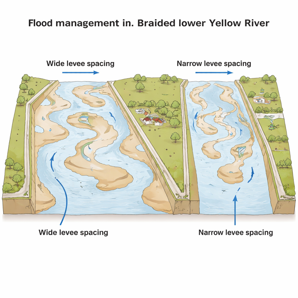
The research focuses on a 275‑kilometer stretch of the lower Yellow River where the channel splits and rejoins around many sandbars, forming what scientists call a braided river. This area runs through intensively farmed land and fast‑growing towns. Decades of engineering, including high levees and upstream dams, have reduced some flood and sediment problems but also squeezed the river, intensified silt build‑up in the main channel, and worsened the “hanging river” condition. In some locations, the riverbed now stands more than a meter above the nearby floodplain, so a levee breach could send water rushing down onto communities and farmland far below.
Two ways to line the river
The authors compare two artificial levee layouts along a key braided reach between Jiahetan and Gaocun: a “wide” spacing scheme and a “narrow” spacing scheme. In the wide option, levees are placed 2 to 5 kilometers apart on average, leaving broad floodplains where high flows can spread out and slow down. In the narrow option, levees are pulled closer together, tightening the corridor that holds the main channel. Narrow spacing better protects existing floodplain settlements and reduces the cost of moving people and infrastructure, but it gives floods less room to spread. A third, “current practice” setup, with many small, low‑standard local levees, serves as a baseline for comparison.
Simulating future floods
To test how these designs behave during storms of different sizes, the team built a two‑dimensional computer model of water flow using a well‑known hydrodynamic program. They calibrated the model with real measurements of water levels and currents from two major flood events, in 1996 and 2020, and showed that simulated and observed values matched closely. Then they ran 21 “what‑if” scenarios that combined three flood severities (typical 5‑year, 10‑year, and rare 100‑year floods) with different levee designs and protection standards. This allowed them to track how peak discharges and water levels changed at several key cross‑sections along the river.
Lower peaks, higher water
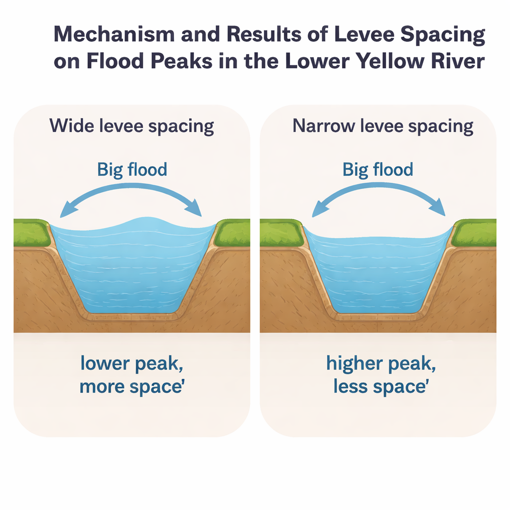
The simulations show that both wide and narrow levee schemes can substantially cut flood peaks compared with the current patchwork of low levees, and that the benefit grows as floods become larger. Under a 100‑year flood, the wide‑spacing design reduces peak flow at the downstream Baocheng section by up to about 986 cubic meters per second, while the narrow scheme achieves a maximum reduction of about 670 cubic meters per second. However, there is a trade‑off: confining the river between stronger levees raises water levels inside that corridor. The narrow scheme, which squeezes the river most, causes the largest increases—up to about 1.45 meters at some points—whereas the wide scheme keeps the rise closer to about 0.6 to 1.1 meters. Upstream sections can even see slight increases in peak flow, while downstream sections gain the strongest reductions, reflecting how floodwaters spread and are temporarily stored on the floodplain.
Balancing safety, space, and cost
When the authors combined water‑level changes across different flood sizes into an overall score, the wide‑spacing scheme performed best: it cut dangerous flood peaks strongly while keeping water‑level rises relatively modest. The narrow‑spacing scheme still reduced peaks and helped protect frequently flooded, heavily populated areas, but at the cost of higher water levels and less room for the river to adjust naturally. The study also notes what it could not yet fully capture: long‑term sediment build‑up and riverbed changes, which may alter how well any design works over decades.
What it means for people living by big rivers
For residents and planners along the Yellow River—and other major rivers worldwide—the message is straightforward. Giving rivers more space with wider levee corridors can be a powerful way to blunt the worst floods, especially rare but catastrophic events. Yet this comes with higher land and relocation costs and continued exposure of some floodplains to water. Narrower levees, by contrast, can shield more communities in everyday conditions but push water levels higher and leave less margin for error. The authors conclude that high‑risk zones with severe flood hazards should favor wide levee spacing, while densely settled areas with more moderate risk may reasonably use narrower levees. Smart flood management, they argue, requires tailoring levee layouts to both the physics of water and the realities of people living along the river.
Citation: Chen, J., Zhang, L. & Wang, H. Evaluating flood peak attenuation effectiveness of levee management strategies in braided river reaches: a case study of the lower Yellow River. Sci Rep 16, 7277 (2026). https://doi.org/10.1038/s41598-026-38415-9
Keywords: flood control, levee design, Yellow River, braided rivers, flood modeling