Clear Sky Science · en
Failure mechanism of a loess slope under extreme rainfall through a model test study of Shixiakou, Lanzhou
Why Wet Hillsides Matter
In many dry regions of China and around the world, steep hills made of fine, dusty soil called loess sit above towns, roads, and railways. These slopes can stand for decades looking stable, yet collapse suddenly after intense rain, burying buildings and cutting off transport. This paper focuses on one such hillside near Lanzhou and asks a practical question: when an extreme rainstorm hits, exactly how does a seemingly solid loess slope unravel, step by step? By recreating the hillside indoors under controlled “storm” conditions, the researchers show how water sneaks into the ground, weakens it from the inside, and turns small cracks and gullying into a full landslide. 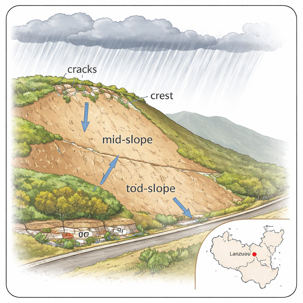
A Fragile Landscape Above a Growing City
The study centers on the Shixiakou landslide area in Lanzhou, a city surrounded by deep valleys cut into thick loess deposits. Statistics show that about 70% of landslides in China are triggered by rainfall, and most happen in the rainy season. In the Lanzhou region, yearly rainfall is modest on average but highly uneven: short, fierce cloudbursts and multi-day storms can dump huge amounts of water over a few hours or days. The slopes above the city are steep, and in many places past erosion and human activity have already carved out terraces, gullies, and loose deposits. This combination of weak soil, steep terrain, and increasingly extreme rainfall makes understanding failure mechanisms more than an academic exercise—it is central to protecting people and infrastructure.
Building a Hillside in the Lab
To watch a landslide evolve without the danger and unpredictability of field conditions, the team built a scaled-down physical model of the Shixiakou slope at 1:50 size inside a steel tank with glass sides. They used real loess from the area, compacted it in layers to create a 1.5-meter-long, 1.4-meter-high slope with an angle similar to the natural hill. Beforehand, they tested the soil in the lab and confirmed that as loess gets wetter, its strength drops sharply: both the “glue” holding grains together and the friction between grains weaken as water fills the pores. Above the model, they installed a custom rainfall simulator that could deliver an intense artificial storm—about 73.5 millimeters of rain per hour, matching recent record cloudbursts in Gansu Province. Inside the slope they embedded sensors to track changes in water content, underground water pressure, and sideways stress in real time, while cameras recorded visible cracking and deformation.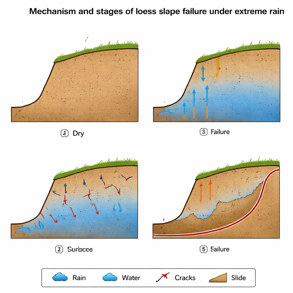
How Water Sneaks In and Weakens the Slope
During the 14-hour simulated storm, the sensors revealed that water did not simply soak in evenly. Instead, a moving “wetting front” advanced downward and differently in each part of the slope. The crest (top) reacted quickly, becoming nearly saturated. The middle and lower parts of the slope showed delayed, uneven wetting, with some points staying relatively dry for hours while others suddenly spiked in moisture. These jumps were linked to the formation of small fractures that acted like hidden channels, guiding water deep into the slope far faster than uniform seepage would. At the same time, underground water pressures rose and horizontal stresses shifted. The toe (bottom) and middle sections experienced larger swings in stress than the crest, signaling that the most dangerous changes were happening out of sight in the body of the slope rather than at the surface alone.
From Surface Scour to Full Landslide
By combining sensor data and visual observations, the team identified a four-stage failure sequence. First, raindrops and runoff carved small gullies and pits in the surface, especially near the toe, where water flow and erosion were strongest. Next, as water accumulated and seeped into the lower slope, the toe began to slip and collapse locally, losing its ability to buttress the material above. In the third stage, this loss of support, together with rising water pressure and stress concentration in the middle of the slope, led to shear failure and the growth of open cracks. These cracks collected rainwater and funneled it inward, further softening the soil along curved paths that would become the eventual slide surface. Finally, after enough cumulative rainfall, the crest area fractured and slid backward in a retrogressive fashion—from bottom toward top—forming a continuous sliding plane and a mass of displaced soil at the base.
Turning Insights into Protection
The authors emphasize that loess slope failures are not instantaneous “on–off” events but progressive processes that create warning signs and intervention windows. Because cracks and gully erosion both speed up water entry and mark zones of weakness, regularly inspecting and promptly filling surface fissures, guiding runoff away with drainage ditches, and reinforcing key sections such as the toe and mid-slope can meaningfully reduce risk. Vegetation, surface strengthening treatments, and monitoring of water content and underground pressure can all help provide early warning before catastrophic sliding occurs. In plain terms, the study shows that extreme rain turns a loess hillside into a slowly collapsing structure from the bottom up—and that understanding this sequence offers practical tools to keep communities below these slopes safer.
Citation: Li, Y., Xin, Y., Tong, M. et al. Failure mechanism of a loess slope under extreme rainfall through a model test study of Shixiakou, Lanzhou. Sci Rep 16, 7628 (2026). https://doi.org/10.1038/s41598-026-38397-8
Keywords: loess landslide, rainfall-induced slope failure, extreme rainfall, slope cracks, landslide early warning