Clear Sky Science · en
Satellite remote sensing enables monitoring of soil organic carbon decline in croplands of Jilin China
Why the Health of Dark Soils Matters
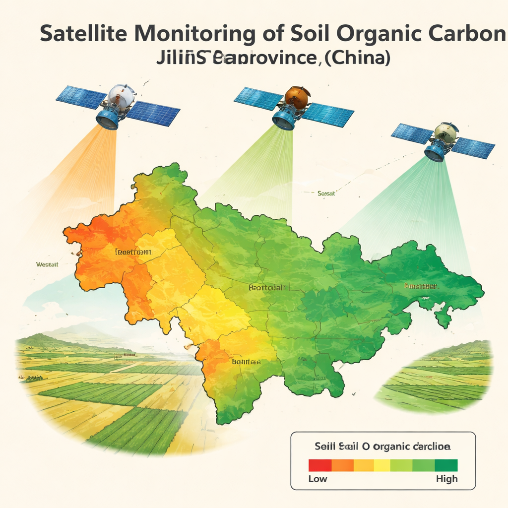
Across the world’s great grain belts, the dark, rich topsoil that feeds our crops is quietly changing. In Jilin Province in Northeast China—a key supplier of corn and rice for the country—scientists have found that this fertile layer is losing some of its stored carbon. That carbon, bound up in decaying plant and animal material, helps soil hold water, nutrients, and life. The new study uses satellites orbiting hundreds of kilometers above Earth to track these invisible changes over time, offering a new way to watch over the health of farmland at a scale no field survey could match.
Hidden Wealth Beneath Our Feet
Soil organic carbon is essentially the “bank account” of life in the ground. It supports crop yields, keeps soil crumbly instead of compacted, helps retain moisture, and underpins biodiversity. Jilin sits in the famous black soil region of Northeast China, where naturally carbon‑rich soils have powered high grain production. But decades of intensive cultivation and erosion have begun to wear down this resource. Traditional monitoring depends on sending people into fields to dig, sample, and analyze soils in the lab, a slow and costly process that produces only scattered snapshots in space and time. Policymakers and farmers need something faster and more consistent if they are to protect this natural capital.
Seeing Soil from Space
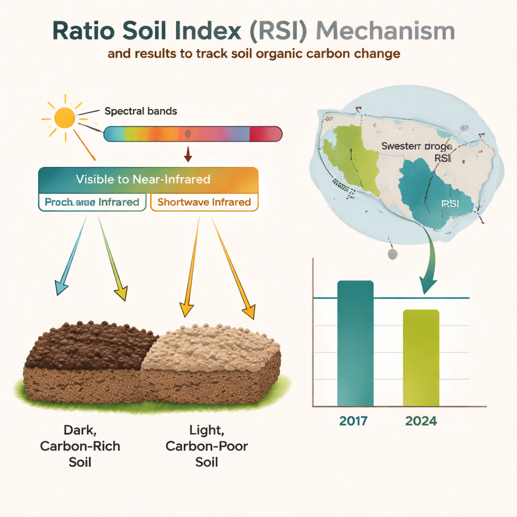
The research team turned to satellite remote sensing, which measures the sunlight reflected from Earth’s surface at different wavelengths. Soils with more organic carbon tend to be darker and change the shape of the reflected spectrum in subtle but detectable ways. The authors combined data from three major satellite systems—MODIS Terra, Landsat 8, and Sentinel‑2—that each offer different trade‑offs in resolution and revisit time. Instead of relying only on heavy statistical models that can be hard to interpret and reuse, they set out to build a simple “spectral index” for soils, similar in spirit to the well‑known NDVI used to monitor green vegetation.
A New Index for Soil Health
Using soil samples collected in 2017 and 2024 at dozens of sites, the team matched ground‑measured carbon levels with satellite reflectance values under carefully chosen bare‑soil conditions. They tested a huge number of two‑band combinations—simple differences, ratios, and normalized ratios—across visible, near‑infrared, and shortwave‑infrared wavelengths. A clear pattern emerged: a ratio between light reflected in a shortwave‑infrared band and light in the red–near‑infrared region tracked soil organic carbon especially well. They formalized this as the Ratio Soil Index (RSI). For all three satellite sensors, RSI correlated strongly with measured carbon, while remaining mathematically simple and physically interpretable. Maps created with RSI reproduced the broad spatial patterns of a global soil database and local field data, capturing higher‑carbon black soils in central Jilin and lower‑carbon areas to the west and in fragmented eastern terrain.
Tracking a Seven‑Year Slide
Armed with the RSI and a time series of Landsat images, the researchers then watched how Jilin’s cropland soils changed between 2017 and 2024. They found that the median RSI for cropland decreased by about 5.14 percent across the province, signaling a measurable decline in soil organic carbon over just seven years. Losses were sharpest in western areas such as Baicheng and Songyuan, while the central black soil belt remained relatively stable and some pockets, like parts of Jilin City and Baishan, showed increases. The spatial pattern of change followed river systems and erosion‑prone zones, hinting at the role of water‑driven soil loss. The team also noted that paddy fields, where straw, water, and mud interact, can confuse the signal and cause underestimation, highlighting where the index works best and where caution is needed.
From Local Plots to National Watchdog
Beyond mapping change, the study showed that RSI behaves in a sensible way over the growing season: it tends to move opposite to vegetation indices like NDVI, making it useful for identifying bare soil windows when the ground is most visible from space. Compared with more complex machine‑learning models, RSI proved easier to share, apply across different satellites, and interpret, while still providing realistic maps of soil carbon patterns. For non‑specialists, the message is clear: a straightforward satellite‑based index can now help track the slow, often invisible decline of soil quality over huge farming regions. While it still needs refinement and broader testing, RSI offers a practical, scalable tool to support better soil conservation policies, precision management on farms, and long‑term protection of the black soils that underpin food security.
Citation: Xu, Z., Hou, D., Lin, N. et al. Satellite remote sensing enables monitoring of soil organic carbon decline in croplands of Jilin China. Sci Rep 16, 6966 (2026). https://doi.org/10.1038/s41598-026-38386-x
Keywords: soil organic carbon, satellite remote sensing, soil health, precision agriculture, black soil regions