Clear Sky Science · en
Elevation uncertainties in the Mekong Delta quantified using a transferable approach
Why the Height of a Delta Matters
The Mekong Delta is home to tens of millions of people and is one of the world’s great food baskets. Yet much of this landscape sits only a few handbreadths above the sea. To understand how vulnerable it is to coastal flooding and rising seas, scientists need to know exactly how high the land really is. This study shows that commonly used global elevation maps can be wrong by more than a meter in such low-lying regions, and it introduces a practical method that any researcher can use to get far more reliable numbers—crucial for planning dikes, roads and future settlements.
Maps That Miss the Mark
Most large-scale assessments of coastal risk around the world rely on global digital elevation models (DEMs), which are made from satellite and radar measurements. These maps are detailed enough horizontally, but their vertical errors can reach several meters. That is a serious problem in flat deltas where differences of just a few centimeters decide whether land stays dry or floods. Earlier work in the Vietnamese Mekong Delta had already shown that widely used global DEMs, such as SRTM or MERIT, overstated average land height by up to several meters—giving a false sense of safety against sea-level rise.
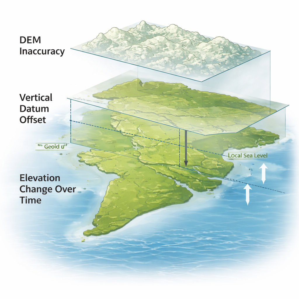
Three Hidden Sources of Error
The authors argue that getting elevation right in coastal lowlands requires tackling three separate issues. First is the built-in inaccuracy of each DEM, caused by how the data are measured and processed; this can introduce striping patterns, spurious bumps or leftover tree and building heights. Second is the “vertical datum” problem: global DEMs are referenced to mathematical surfaces (geoids or ellipsoids) that do not match the actual local sea level, which can differ by more than a meter along some coasts. Third is time. Many DEMs are based on data that are decades old, while deltas like the Mekong are sinking by centimeters per year due to groundwater extraction and natural compaction, even as the sea itself rises.
Re-measuring the Mekong Delta
To untangle these effects, the researchers updated a high-quality local elevation map for the Vietnamese Mekong Delta (TopoDEM_v2) so that it is tied to present-day, continuously mapped local mean sea level, derived from satellite altimetry. They then converted 11 widely used global DEMs—old and new, including SRTM, ASTER, TanDEM-X, Copernicus, CoastalDEM, GLL-DTM and DeltaDTM—onto the same local sea-level reference. Comparing every DEM cell-by-cell with the local reference allowed them to measure not only how large the errors are, but also how much of each error comes from raw inaccuracy, from using the wrong vertical datum and, tentatively, from land subsidence and sea-level rise that have occurred since each dataset was collected.
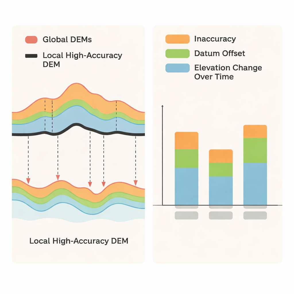
Which Elevation Maps Can Be Trusted?
The assessment shows huge differences between products. Older satellite-based DEMs and some of their post-processed versions still contain strong artefacts and often misrepresent the delta’s height by several meters, making them unsuitable for precise flood modeling. Newer coastal-focused DEMs that incorporate laser measurements from the ICESat-2 satellite perform far better. In particular, GLL-DTM (when its datum is correctly converted) and DeltaDTM show errors of only a few tens of centimeters relative to the local reference, capturing both the flatness and very low overall elevation of the delta. For these best-performing models, a large share—up to roughly half—of the total uncertainty comes from vertical datum mismatches rather than from the DEM measurements themselves, meaning that simple but careful conversion to local sea level yields a big payoff in accuracy.
What This Means for People Living on the Delta
For residents, the technical details boil down to a stark message: the Mekong Delta is, on average, only about 0.8 meters above the local sea surface, lower than many global maps suggest, and it is sinking while the sea rises. That means flood risks and long-term inundation have been widely underestimated. The method presented in this paper—using open global data to correct for datum offsets, update for subsidence and sea-level rise, and check model performance against any available local measurements—can be applied to many other data-poor coasts worldwide. Doing so will give a much clearer picture of which lands are truly at risk and will help governments and communities design realistic defenses and adaptation strategies before the water arrives.
Citation: Seeger, K., Minderhoud, P.S.J. Elevation uncertainties in the Mekong Delta quantified using a transferable approach. Sci Rep 16, 4993 (2026). https://doi.org/10.1038/s41598-026-38315-y
Keywords: Mekong Delta, digital elevation model, sea-level rise, land subsidence, coastal flooding