Clear Sky Science · en
Extensive fluid overpressure in the shallow slow earthquake zone of Nankai Trough off Muroto mapped with high-resolution P-wave velocity
Hidden Forces Beneath the Seafloor
Along Japan’s southern coast, one of the world’s most closely watched earthquake zones quietly stores water under immense pressure. In the Nankai Trough, some earthquakes rupture violently, while others creep slowly over days or weeks. This study peels back the seafloor off Cape Muroto to reveal how deeply buried, highly pressurized fluids may help explain where and why these unusual “slow earthquakes” occur—and what that could mean for future great quakes and tsunamis.
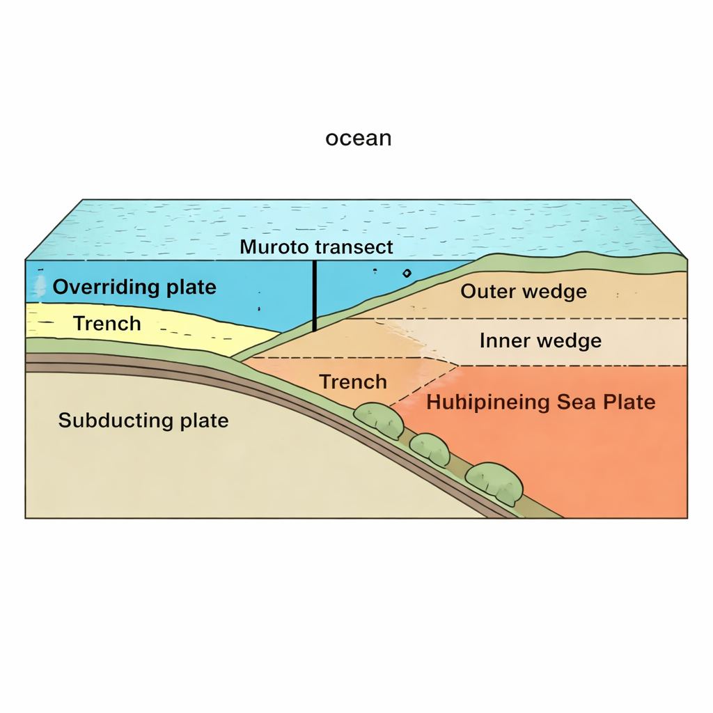
A Busy Collision Zone Offshore Japan
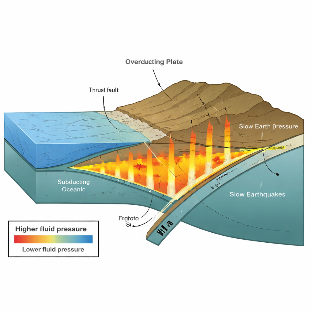
The Nankai Trough is a giant underwater trench where an oceanic plate dives beneath Japan. This process, called subduction, builds a thick pile of sediments and rock on the overriding plate and powers major earthquakes. Off Muroto, the region where slow earthquakes occur lies at shallow depths, within about 10 kilometers of the surface. Scientists suspect that fluids squeezed from sediments play a key role in how the rocks slip—sometimes smoothly and quietly, sometimes in destructive jolts.
Listening to Waves to Map Buried Water
To see what is happening kilometers below the seafloor, the authors used a detailed image of how fast seismic waves travel through the crust. These “P-waves” move more slowly through softer, more fluid-filled sediments and faster through stiff, compacted rocks. By applying lab-based formulas that link wave speed, rock porosity, and stress, the team translated the wave-speed map into estimates of how much of the weight of overlying rock is carried by trapped fluids rather than by the grains themselves. This yielded a high-resolution map of a quantity called the pore pressure ratio, which shows how close the fluids are to supporting the full weight of the rocks above.
Extensive Zones of Overpressured Sediments
The results reveal a broad region, extending from the main offshore fault (the frontal thrust) to roughly 60 kilometers landward and down to about 8 kilometers depth, where fluid pressures are high over a wide area. Within this zone, the underthrust sediments nearer the trench host scattered “patches” where pressures are especially high, behaving like overpressured aquifers that match earlier drill-hole observations of unexpected mud outflow. Deeper beneath the inner part of the margin, a continuous belt of very high pressure lines up with a layer of sediments that has been scraped from the seafloor and welded onto the overriding plate—material thought to be rich in water-bearing trench deposits that have been dragged downward.
Seamounts, Faults, and Slow Quakes
Nearby, several submerged volcanic hills, or seamounts, are being pulled into the subduction zone. Earlier work suggested that as these seamounts plow into the margin, they squeeze the underplated, water-rich sediments and raise fluid pressures on their landward side. The new quantitative pressure map supports that picture: high-pressure regions coincide with the underplated layer and with areas where slow earthquakes and rare cold seeps have been recorded at the seafloor. Vertical streaks of high pressure along thrust faults hint that these fractures act as conduits, allowing fluids to rise. In many places, the pressure approaches conditions where rocks become extremely weak, creating ideal settings for slow, creeping slip rather than fast rupture.
What This Means for Future Earthquakes
For non-specialists, the main takeaway is that water under very high pressure is not a minor detail but a widespread feature of the shallow Nankai subduction zone off Muroto. The study shows that much of the region where slow earthquakes happen is overpressured, and that the distribution of this pressure is shaped by subducted seamounts, layers of underplated sediment, and networks of faults that act like plumbing. These findings help explain why some parts of the fault slip slowly and may at times act as barriers or gateways for larger ruptures. Better maps of this hidden fluid system should improve our understanding of how and where future large earthquakes and tsunamis might start, and how subtle slow-slip events fit into the broader earthquake cycle.
Citation: Flores, P.C.M., Kodaira, S., Shiraishi, K. et al. Extensive fluid overpressure in the shallow slow earthquake zone of Nankai Trough off Muroto mapped with high-resolution P-wave velocity. Sci Rep 16, 7636 (2026). https://doi.org/10.1038/s41598-026-38308-x
Keywords: Nankai Trough, slow earthquakes, fluid overpressure, subduction zone, seamount subduction