Clear Sky Science · en
Compound flood simulations indicate rising public exposure to sewage-contaminated waters in Waikīkī, Hawai‘i
Why this matters to everyday life
Waikīkī in Honolulu is famous for its beaches and hotels, but this study shows that the same setting that draws visitors also hides a growing health risk. As seas rise and heavy rainstorms become more common, floodwaters in Waikīkī are increasingly likely to come not just from the ocean and sky, but from a canal and groundwater laced with sewage and other pollution. Understanding this shift helps residents, visitors, and planners see floods not only as wet streets and damaged buildings, but as a serious public health concern that demands new kinds of protection.
A crowded shoreline on the edge
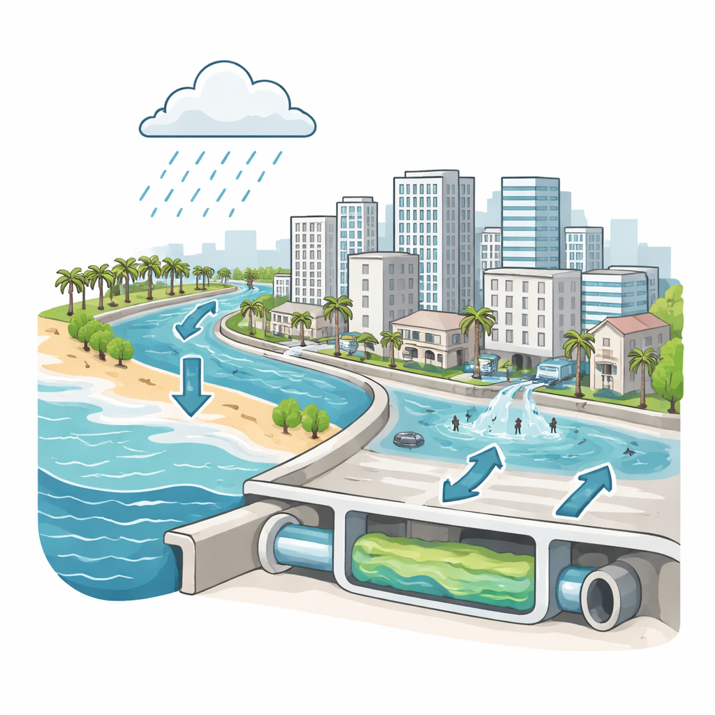
Waikīkī is a tightly packed neighborhood built on former wetlands, with most of its ground only a few meters above sea level and much of its surface covered by pavement. A man-made waterway, the Ala Wai Canal, rings the inland side of the district and carries runoff from a large urban watershed out to the ocean. Over time, this canal has become heavily contaminated by sewage leaks, stormwater, fertilizers, and other urban pollutants. The area’s storm drains send street runoff toward the canal by gravity, assuming that water in the canal sits low enough to let flows escape. Rising seas and higher tides challenge this design, making it harder for water to drain away when heavy rain falls.
Following the water during real storms
The researchers used an advanced, open-source computer model called WRF-Hydro-CUFA to follow how water moves through Waikīkī during storms. The model links together rainfall on roofs and streets, runoff from hillsides, tides and waves along the coast, underground water in the soil, and the maze of storm drains that crisscross the district. They tuned and tested the model using three recent heavy-rain events, comparing simulated water levels with measurements in the canal, in a nearby stream, and in a groundwater monitoring well, as well as with numerous photos and videos of actual street flooding. The model successfully matched observed tides, rainfall pulses, and flood locations, giving confidence that it can capture how different flood sources interact in this complex setting.
When the ocean pushes back
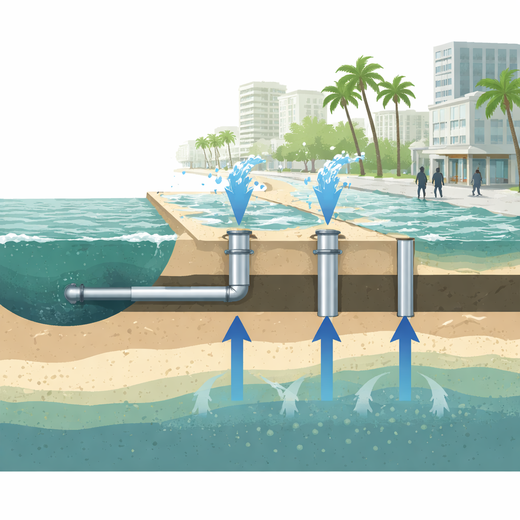
With the model calibrated, the team then asked what happens as sea level rises in steps up to 1.2 meters, roughly in line with U.S. federal projections for Honolulu by the end of the century. They reran two of the storms under these higher sea levels and also simulated conditions with tides alone, without rain. As sea level rose, high water in the Ala Wai Canal began to overwhelm the storm drain outlets, first blocking them and then forcing canal water backward through the drainage pipes into city streets. Even with no rainfall, elevated tides alone eventually produced widespread "sunny-day" flooding as canal water surged inland and as the storm drains became pathways for contaminated water to reach sidewalks and roads. At the same time, higher seas raised the groundwater table beneath Waikīkī, leaving the soil column almost permanently saturated and reducing its ability to soak up rain.
From rain-driven floods to chronic dirty water
One of the study’s most important findings is that the main driver of flooding in Waikīkī shifts as seas rise. Under present-day conditions, heavy rain is responsible for most flooded area, with tides mainly making drainage less efficient. But as sea level climbs toward one meter and beyond, the balance flips: tidal influence and higher baseline water levels dominate, and rainfall becomes a secondary trigger. In the most extreme simulations, more than two-thirds of Waikīkī is inundated during a strong storm, and most of that flooding is tied directly or indirectly to the canal rather than to fresh rainwater. Because the Ala Wai Canal frequently carries sewage-related pathogens, and because rising groundwater is also contaminated by leaking sewer lines and old cesspools, the study shows that future floods will increasingly spread polluted water through homes, streets, and public gathering places even during moderate weather.
What this means for health and planning
For non-specialists, the takeaway is stark: in Waikīkī and similar low-lying coastal cities, future floods are less about clean ocean water gently overtopping a seawall and more about dirty canal and groundwater backing up into daily life. As sea level rise turns tides and groundwater into constant pressure on drains and foundations, occasional storms will simply add to an already saturated system. The authors argue that flood planning must therefore look beyond sea walls and surface damage to include water quality, failing drainage, and aging sewage pipes. Modernizing stormwater and wastewater infrastructure, monitoring contaminated waterways, and preparing health responses will be crucial to keep beloved coastal districts both dry and safe as the climate continues to change.
Citation: Yamamoto, K., Habel, S., Son, Y. et al. Compound flood simulations indicate rising public exposure to sewage-contaminated waters in Waikīkī, Hawai‘i. Sci Rep 16, 9740 (2026). https://doi.org/10.1038/s41598-026-38225-z
Keywords: compound flooding, sea-level rise, urban drainage, water contamination, Waikiki