Clear Sky Science · en
River extraction from high-resolution remote sensing images based on non-uniform sampling and semi-supervised learning
Why mapping rivers from space matters
Rivers shape our farms, cities, and floodplains, yet on-the-ground monitoring is expensive and patchy. Today’s Earth-observing satellites can photograph every bend and side channel in astonishing detail, but turning those images into clean, reliable river maps is still a technical challenge. This study presents a new way to automatically trace rivers from high‑resolution satellite pictures, aiming to provide more accurate information for irrigation planning, flood warning, ecosystem protection, and water‑resources management—while also cutting down the amount of human labeling work normally required.
The challenge of finding rivers in complex images
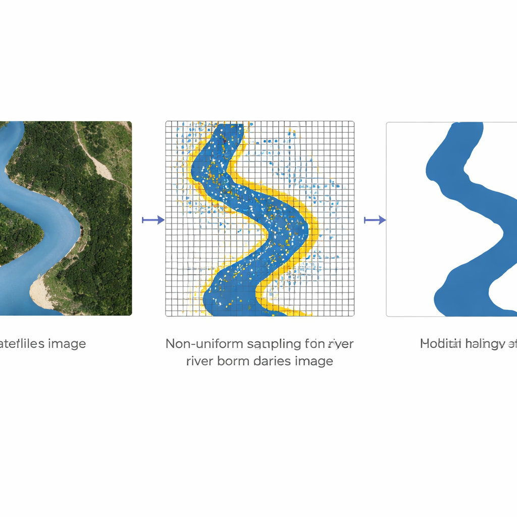
Modern mapping systems often rely on deep learning, a technique where computer models learn to recognize patterns, such as water versus land, from many example images. These systems work well for broad features but struggle with details. In satellite scenes, riverbanks can be only a few pixels wide, tangled with roads, shadows, and buildings that look similar in color and brightness. Standard “encoder–decoder” networks treat every pixel equally when they learn, which means they waste effort on large uniform areas like fields or lakes while not paying enough attention to narrow boundaries where errors matter most. On top of that, creating precise training maps—where a human has traced every river—is slow and costly, so labeled data are scarce.
A smarter way to focus on river edges
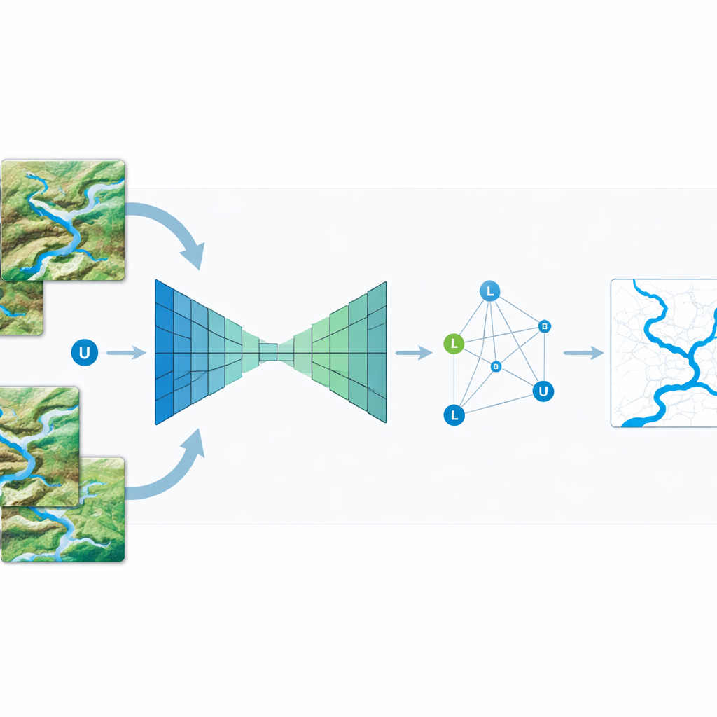
The authors tackle these problems with a technique called non‑uniform sampling. Instead of feeding the network all pixels with equal weight, they deliberately select more points in “high‑frequency” regions—places where colors and brightness change quickly, such as the edges between water and land—and fewer points in smooth areas. Coarse information from the deeper layers of the network, which sees the big picture, is combined with fine details from the shallower layers, which capture crisp edges. Bilinear interpolation, a simple way of averaging values in two directions, is used to blend these coarse and fine signals so that each selected point reflects both local detail and broader context. By repeatedly refining only these carefully chosen points, the model can sharpen river outlines without the heavy cost of analyzing every pixel at full resolution.
Learning from unlabeled images as well
To further boost performance, the study adds semi‑supervised learning, which allows the system to benefit from many unlabeled satellite images. The method treats each image patch—labeled or unlabeled—as a node in a graph and connects similar patches to one another. Information from the few patches with known river labels then spreads across this graph, gently nudging the predictions for unlabeled patches to be consistent with their closest neighbors. In practical terms, this means the model can “borrow” structure from the unlabeled images, learning where rivers tend to appear and how they relate to surrounding landscapes, even when no human has drawn the river lines for those particular scenes.
How much better does it work?
The researchers tested their approach on a large Chinese satellite dataset (Gaofen‑2) and on the global OpenEarthMap collection. When they plugged non‑uniform sampling into three widely used river‑mapping networks—Unet, Linknet, and DeeplabV3—all of them became more accurate and converged faster during training. Measured by standard scores such as pixel accuracy and intersection‑over‑union, river detection improved by roughly one to three percentage points just from smarter sampling. When they then added semi‑supervised learning and fed in all available unlabeled images, accuracy jumped by about five percentage points and the overlap score by more than nine points. The method also compared favorably with leading semi‑supervised techniques such as Mean Teacher and Cross Pseudo Supervision, and it did so while using less computation than a strong DeeplabV3 baseline.
What this means for real‑world river mapping
For non‑specialists, the takeaway is straightforward: the authors have built a system that can trace rivers from satellite images more cleanly and efficiently by concentrating its attention on riverbanks and by learning not only from carefully labeled examples but also from the vast pool of unlabeled imagery. This reduces the manual effort required from experts and yields river maps with fewer breaks, sharper edges, and fewer mix‑ups with roads or shadows. Although developed for rivers, the same idea—smart sampling plus semi‑supervised learning—could help automatically map other narrow features such as roads and canals, making large‑scale environmental monitoring more accurate and more affordable.
Citation: Wang, K., Han, L. & Li, L. River extraction from high-resolution remote sensing images based on non-uniform sampling and semi-supervised learning. Sci Rep 16, 6816 (2026). https://doi.org/10.1038/s41598-026-38167-6
Keywords: river mapping, remote sensing, deep learning, semi-supervised learning, satellite imagery