Clear Sky Science · en
Role of hydraulic parameters in the concentration and spatial distribution of heavy metals in sediments in a two-stage reservoir
Why hidden metals in reservoirs matter
Across the world, dams and reservoirs help us cope with floods, droughts, farming needs, and electricity demand. But as they slow rivers, they also act like giant traps for mud and pollution washed off the land. This study looks at a Polish reservoir that was deliberately built in two stages to catch contaminated sediment before it reaches the main water body. The researchers wanted to know: how strongly do water flow patterns shape where heavy metals end up on the reservoir floor, and does the two-stage design really help protect water quality? 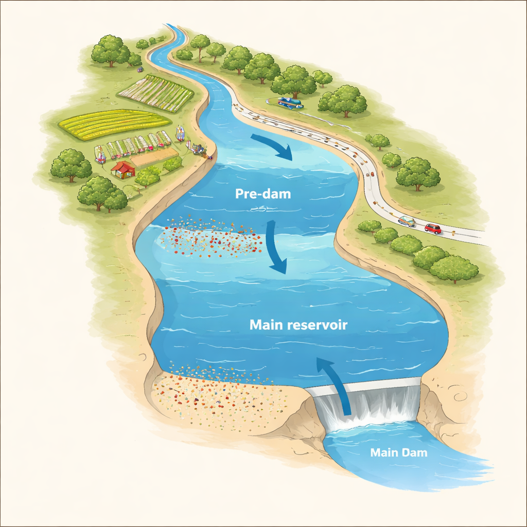
A river, a two-part lake, and upstream pollution
The Stare Miasto reservoir lies on the Powa River in central Poland. Its catchment is dominated by farmland, with some forest and a small share of towns; a major highway crosses the reservoir. Fields, vehicles and settlement runoff all supply trace amounts of toxic metals such as zinc, lead, copper, chromium, nickel and cadmium. The reservoir is split into a smaller upper “pre-dam” basin and a larger main basin downstream. The idea is simple: let most of the mud and attached pollutants settle out in the pre-dam, which can be dredged from time to time, while keeping the main basin cleaner for water supply, recreation and flood control.
Sampling the mud and measuring the flow
To see how well this concept works in practice, the team collected 30 surface sediment samples from both the pre-dam and main parts of the reservoir. In the lab they separated the grains by size and measured how much of each metal was present using sensitive mass spectrometry. In parallel, they used detailed computer modeling of water movement (the IBER 2D hydraulic model) to map how fast water flows in each part of the reservoir and how strongly it can move particles along the bottom. Rather than looking only at speed, they also calculated other flow characteristics, such as the Froude number, shear stress, and specific discharge, which together describe how easily fine material can be carried or dropped.
Where the metals settled—and why
The sediments contained all six metals everywhere, and their levels tended to rise and fall together, suggesting shared sources from farming, traffic and other human activities. Zinc was most abundant, followed by lead and copper. On average, metal concentrations were higher in the pre-dam, even though that zone had been dredged just five years earlier, while the main basin had accumulated sediment for roughly twelve years without cleaning. This means the pre-dam built up contamination about two and a half times faster, confirming its role as a deliberate “pollution sink.” Still, overall contamination relative to natural background was low at most sites, with only one spot near the highway showing clear enrichment and the greatest ecological risk. There, thick layers of newly deposited fine sediment coincided with elevated metal levels, highlighting how hotspots emerge where slow water allows silt and clay to settle. 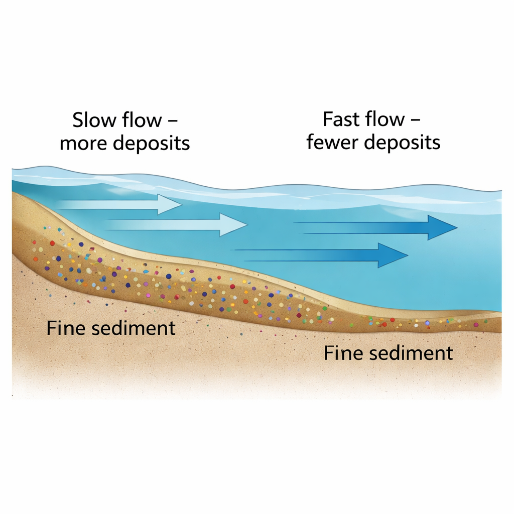
Flow patterns as a hidden control knob
Statistical analysis showed that the finest grains—silt and clay—held the most metals, while sandier spots had lower levels. Crucially, the hydraulic parameters from the model helped explain this pattern. In the pre-dam, locations with slower, calmer flow tended to collect more fine particles and thus more metals. Measures of flow intensity, such as velocity and Froude number, were negatively linked to copper and zinc: where water moved faster and had more energy to keep particles suspended, fewer metals accumulated in the surface mud. In the main basin, copper levels rose with increasing specific discharge in some zones, pointing to subtle local differences in how water spreads across the bed. Together, these results show that not only the amount of pollution, but also how water moves through a reservoir, governs where contaminants are stored.
What this means for safer reservoirs
For non-specialists, the key takeaway is that the design and internal hydraulics of a reservoir can strongly steer where toxic metals are parked for years or even decades. In Stare Miasto, the two-stage design successfully concentrates most contaminated sediment in the pre-dam, which can be managed more easily, while helping shield the main basin. Yet the study also shows that pollution is never stopped completely: metals still reach the lower reservoir, and local features like highways can create new hotspots. By combining mapping tools, sediment chemistry and detailed flow models, water managers can better locate these risk zones, plan sediment removal, and adapt reservoir operation to keep important water bodies safer in a changing climate.
Citation: Jaskuła, J., Dysarz, T., Wicher-Dysarz, J. et al. Role of hydraulic parameters in the concentration and spatial distribution of heavy metals in sediments in a two-stage reservoir. Sci Rep 16, 6958 (2026). https://doi.org/10.1038/s41598-026-38103-8
Keywords: reservoir sediments, heavy metals, water flow, pollution hotspots, dam design