Clear Sky Science · en
Research on the predicted height of water-conducting fracture zones based on the BO-RFR model and SHAP analysis
Why Cracks Above Coal Mines Matter
Deep underground, coal mining quietly reshapes the rocks above it. When those rocks crack all the way up to water‑rich layers, underground rivers can suddenly pour into a mine, threatening workers, equipment, and nearby ecosystems. This study asks a practical question with life‑and‑death consequences: how tall do these crack zones grow, and can we predict their size reliably enough to mine safely under water‑bearing rocks?
Hidden Pathways for Water Underground
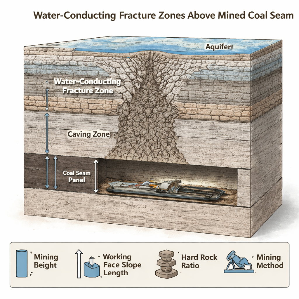
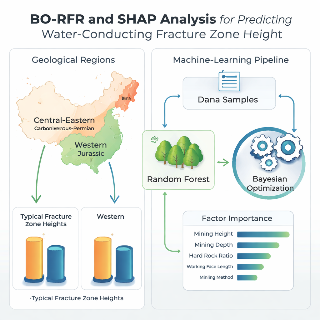
When a coal seam is mined out, the roof above it bends, sags, and eventually breaks. This damage creates a vertical zone of broken and fractured rock called a water‑conducting fracture zone. If that zone reaches an overlying aquifer, the cracks can become a hidden pathway for water to rush into the mine. China, which relies heavily on coal, faces this challenge across very different geological settings. In the central and eastern regions, most coal lies in older Carboniferous–Permian rocks that are deep and strong. In the western regions, coal sits in younger Jurassic rocks that are shallower and mechanically weaker. These contrasts mean that the same mining activity can create very different fracture heights in different parts of the country.
From Rule‑of‑Thumb to Data‑Driven Prediction
For decades, engineers estimated fracture heights using simple formulas or computer simulations. Those methods often focused on just one factor, such as the thickness of the coal seam extracted, and ignored other important influences. They also struggled to adapt to complex, changing geology. In this study, the authors compiled 258 real‑world measurements of fracture height from representative mines: 147 from the older eastern coalfields and 111 from the younger western ones. For each site they recorded five practical variables that mine planners know well: how thick a slice of coal was removed (mining height), how deep the seam lies, how long the mined panel is, how much strong rock is mixed into the overlying layers (hard rock ratio), and which mining method was used.
Teaching a Forest of Algorithms to Read the Rocks
To make sense of this mixed, imperfect data, the team turned to a machine‑learning approach called random forest regression, a method that combines many decision trees into a single, robust predictor. They then used Bayesian optimization—an efficient search strategy—to automatically tune the model’s internal settings so it would perform well even with relatively few samples. This combined BO‑RFR model was trained separately for the eastern and western coalfields, then rigorously tested and cross‑checked on unseen data, including "blind" samples from additional mines. Across all tests, the optimized model predicted fracture heights far more accurately than traditional formulas and several other advanced algorithms, capturing the complex, nonlinear way that geology and mining design interact.
Unpacking What Matters Most
Powerful models are only useful if engineers can understand and trust them. To open the "black box," the authors used a modern interpretability tool called SHAP, which estimates how much each input factor pushes a prediction up or down for every single case. This analysis showed that in both old and young rock, one lever dominates: mining height is by far the strongest driver of how tall fracture zones grow. But the second‑most important factor flips between regions. In the older, stronger Carboniferous–Permian rocks, the hard rock ratio ranks just behind mining height, reflecting the key role of thick, stiff layers in holding the rock mass together. In the younger, weaker Jurassic rocks, mining depth plays the larger role, tying fracture growth more closely to overall overburden weight and stress rather than to individual strong layers.
Turning Insights into Safer Mines
By combining field data, a carefully tuned machine‑learning model, and a transparent way to explain its decisions, this study offers mine planners a practical roadmap. In eastern China’s older, hard‑rock coalfields, safe designs should focus on mapping and understanding key strong layers and limiting the mining height beneath them. In the western, softer Jurassic basins, engineers should pay closer attention to depth‑related stresses and the risk of large, unstable collapses, treating mining height and depth as joint controls. Overall, the work shows that advanced, explainable algorithms can move the industry beyond one‑size‑fits‑all rules, toward tailored, evidence‑based strategies that better protect miners and water resources alike.
Citation: Qiu, M., Wen, Y., Teng, C. et al. Research on the predicted height of water-conducting fracture zones based on the BO-RFR model and SHAP analysis. Sci Rep 16, 7230 (2026). https://doi.org/10.1038/s41598-026-38043-3
Keywords: coal mining safety, groundwater hazards, rock fractures, machine learning models, China coalfields