Clear Sky Science · en
Hydrogeophysical characterization and recharge potential of three Wadi basins along the Red Sea Margin, Northeastern Desert, Egypt
Why Dry Valleys Matter for Hidden Water
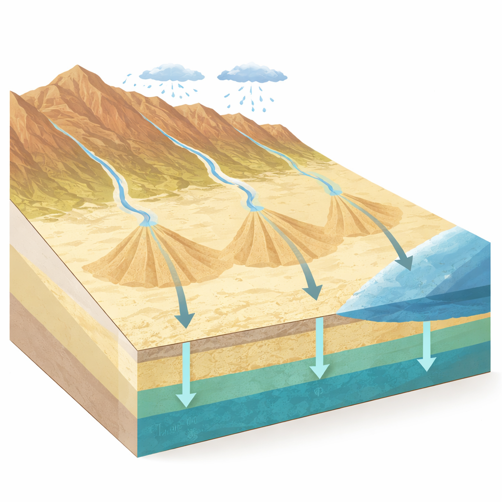
In one of the driest parts of Egypt, brief desert storms can release sudden torrents of water down normally dry riverbeds, known as wadis. Most of that water disappears from sight within hours—but it does not vanish. This study asks a crucial question for water-scarce countries: where does that water go underground, and how can we safely store more of it as groundwater? By combining satellite images, ground-based measurements, and simple physics, the researchers map out which parts of three wadi systems along the Red Sea margin are best suited to capture and hold precious freshwater beneath the surface.
A Harsh Landscape with Hidden Pathways
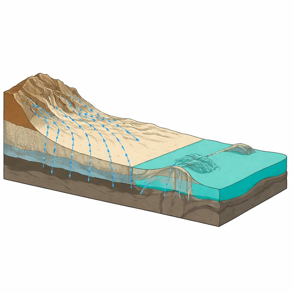
The team focused on three neighboring drainage basins—Wadi Ramliya, Wadi Umm Alda, and the smaller, steeper Wadi Hamad—in Egypt’s Northeastern Desert near the Red Sea. Here, ancient seas, rivers, and volcanic episodes have stacked rocks and sediments in layers, later cracked and tilted by the opening of the Red Sea and Gulf of Suez. Today, this history shows up as a landscape of rugged highlands feeding broad, low-lying coastal plains. Using detailed digital elevation models, the researchers divided the terrain into four broad zones: high, dissected uplands where storms generate fast runoff, and gentler lowlands and coastal plains where those flows slow down, spread out, and often soak into the ground.
Reading the Desert from Space and from Below
From above, the scientists analyzed satellite-based elevation and shaded-relief images to trace drainage networks and linear features that mark faults and fractures in the bedrock. These structural trends are dominated by northwest–southeast and northeast–southwest directions, matching the regional rift system and strongly steering how water moves across the surface. By calculating basic shape and relief metrics for each basin, they showed that Wadi Hamad, though much smaller, is carved by dense, steep channels that favor sudden flash floods and heavy sediment transport. In contrast, the much larger Ramliya and Umm Alda basins act more like long delivery systems, carrying water and sediment toward wide, sandy fans near the coast where flows can slow and spread.
Peering into the Ground for Aquifers
Looking below the surface, the team used electrical and magnetic surveys—essentially measuring how rocks conduct electricity and respond to Earth’s magnetic field—to draw a six-layer picture of the subsurface. They identified thin, very coarse wadi gravels near the surface, several sand and clay layers, and, crucially, a deeper Middle Miocene layer of calcareous sandstone and sandy limestone that behaves as a regionally important aquifer. This aquifer lies roughly 77–122 meters deep and shows resistivity and porosity values consistent with substantial storage space for water. A calibration well indicates that this deeper water is slightly salty, but still suitable for many non-drinking uses, such as some types of irrigation or industry.
Where Floods Become an Opportunity
To identify the best places where short-lived floods can recharge aquifers, the researchers combined long-term rainfall records from the nearest rain gauge with satellite rainfall estimates and landscape factors such as slope, drainage density, land cover, and distance from roads. They mapped flood-hazard zones into classes from very low to very high. The most flood-prone cells are concentrated where wadis exit the highlands and spread into low-slope alluvial fans and coastal plains. Importantly, these are the same areas where geophysical data show thick, permeable sediments overlying key aquifer layers. Structural highs and lineament intersections also emerge as promising sites, because fractures there can guide water deeper into the rock.
Turning Desert Storms into Reliable Supply
For water managers, the study offers more than a geological snapshot; it outlines practical next steps. The authors recommend pilot projects that capture episodic flood flows at the toes of alluvial fans—using simple structures to slow and spread water—combined with carefully placed test wells at major fracture intersections. These efforts should be paired with sediment control (to prevent pore spaces from clogging), downhole logging, pumping tests, and ongoing water-quality monitoring. In plain terms, the work shows how brief, sometimes destructive desert floods can be turned into a planned groundwater savings account, provided we know where the subsurface "banks" are located and manage them with care.
Citation: Hussein, M., Araffa, S.A., Abbas, M.A. et al. Hydrogeophysical characterization and recharge potential of three Wadi basins along the Red Sea Margin, Northeastern Desert, Egypt. Sci Rep 16, 7934 (2026). https://doi.org/10.1038/s41598-026-37853-9
Keywords: groundwater recharge, wadi hydrology, Red Sea margin, arid-zone water, geophysical mapping