Clear Sky Science · en
SFEL a machine learning framework for forecasting radar backscatter based ground deformation
Watching the Hills Before They Move
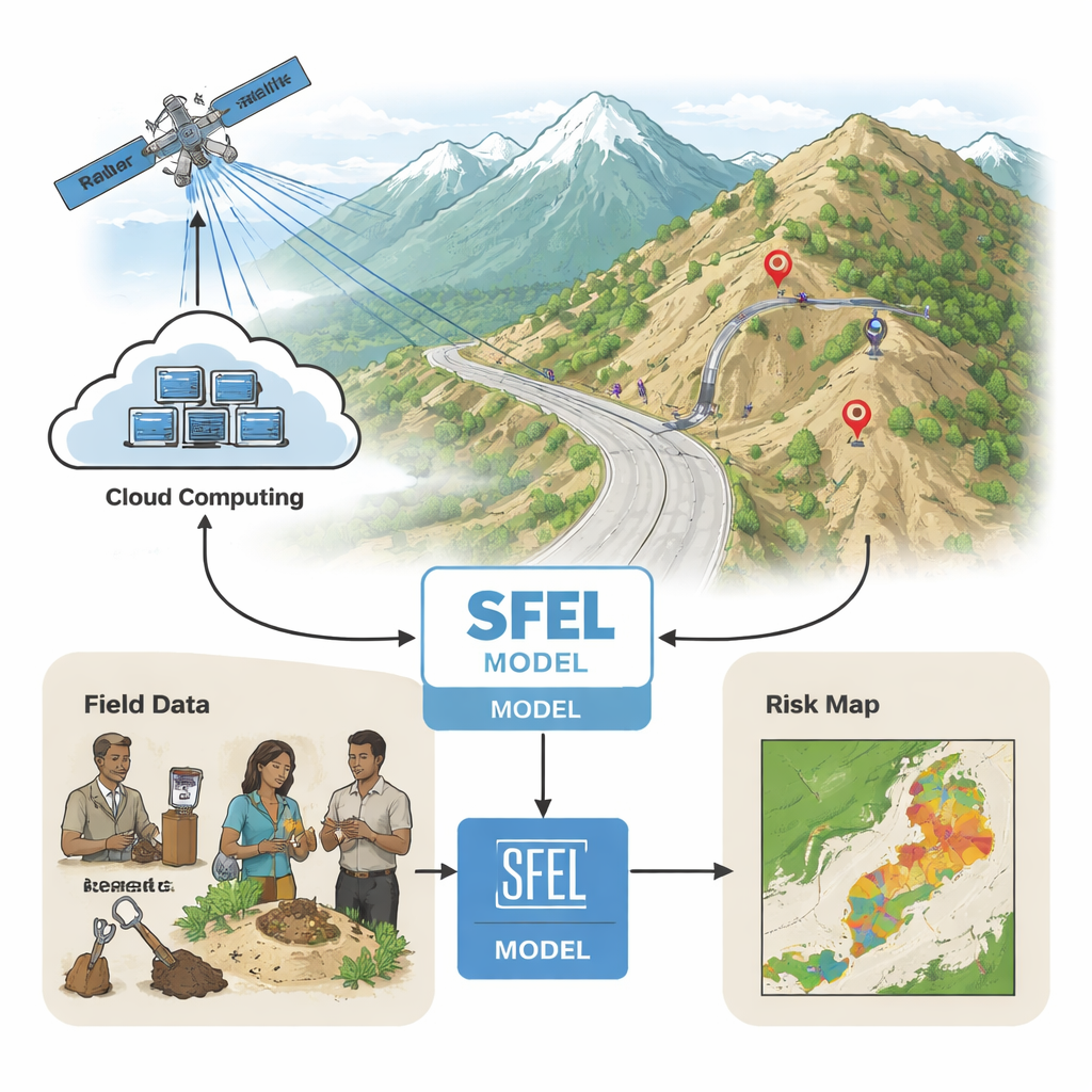
Mountain roads and villages can seem solid, but in places like India’s Himalayan foothills the ground is slowly shifting underfoot. Sudden landslides routinely cut highways, damage homes, and threaten lives. This study explores a new way to “listen” to these restless slopes using satellite radar, soil tests, and local knowledge, then feed all of that into a machine-learning system that can forecast subtle ground changes months in advance.
A Hazard Hidden in the Soil
The researchers focus on a landslide-prone highway corridor in the Mandi district of Himachal Pradesh, a mid-Himalayan region with steep slopes, heavy monsoon rains, and complex geology. Here, even small changes in the soil’s strength or moisture can tip the balance between stability and collapse. Traditional field investigations rely on drilling, lab tests, and expert judgment, but these methods are expensive, slow, and limited to a few locations. At the same time, satellite radar has become very good at detecting past ground movement, yet is rarely used to predict what will happen next. The challenge is to combine these scattered clues into a practical early-warning tool.
Blending Satellites, Lab Tests, and Local Wisdom
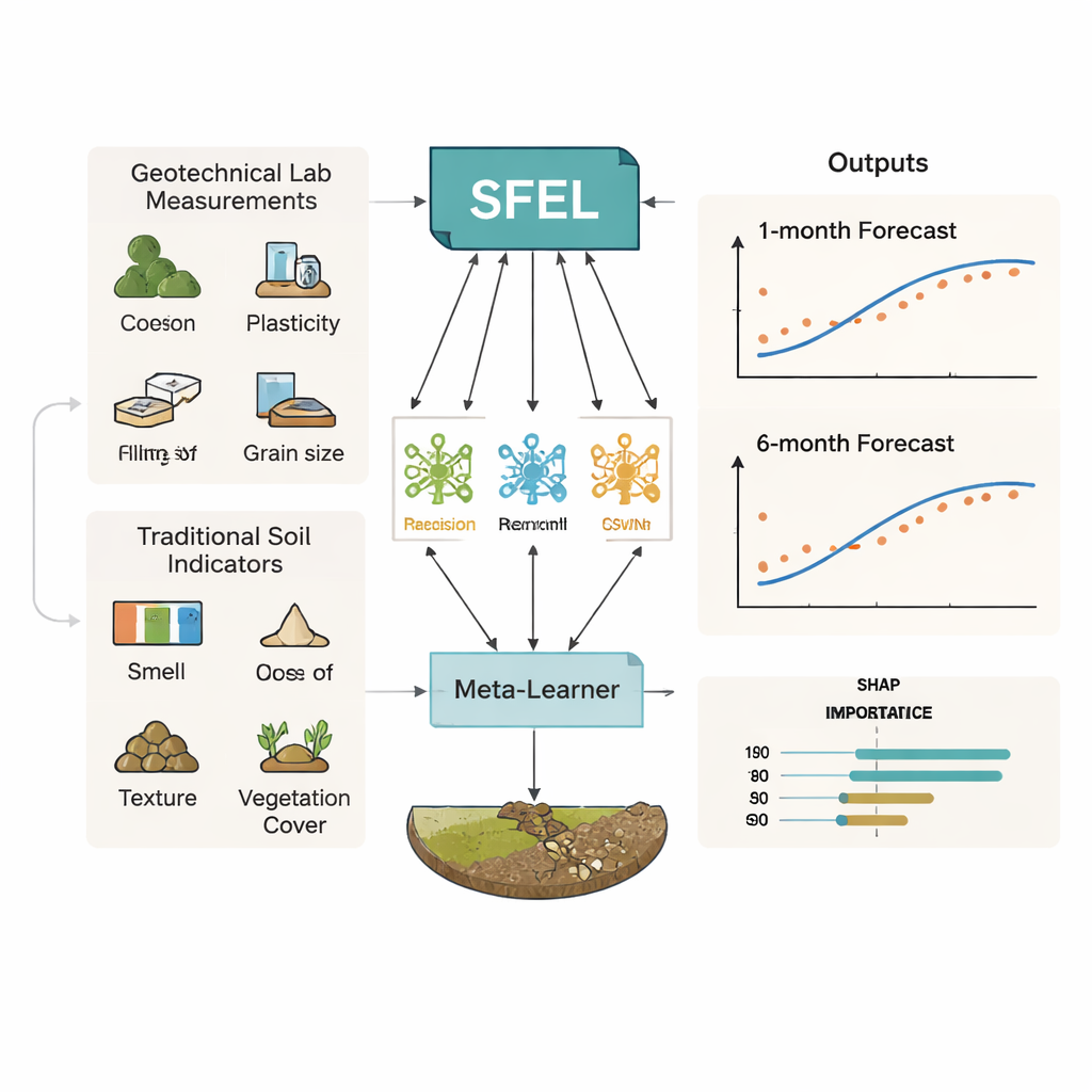
The team collected data from 110 sites along the highway, including 55 known landslide locations and 55 relatively stable spots. In the lab, they measured standard geotechnical properties: how sticky or plastic the soil is, how much water it can hold, how dense and porous it is, and how much sand, silt, and clay it contains. In the field, they also captured the kinds of cues that local residents and experts have used for generations: soil color, feel between the fingers, earthy smells, how moist or compact the ground seems, and how healthy the vegetation looks. These “traditional” indicators were carefully scored on a five-point scale by 12 trained observers to turn human perception into usable numbers.
Turning Radar Echoes into Deformation Signals
To watch the slopes over time, the researchers tapped into Sentinel‑1 satellite radar data processed on Google Earth Engine, a cloud-based mapping platform. Rather than computing full 3D ground motion, they tracked changes in radar backscatter—the strength of the radar echo from the surface—over a two-year period. By comparing each month’s signal to an earlier reference, they obtained a simple measure called ΔVV that reflects how the surface is changing: persistent decreases often signal subsiding or compacting ground, while increases can indicate more moisture or vegetation growth. Although ΔVV does not directly state how many millimeters the land has moved, it acts as a sensitive proxy for deformation that can be measured consistently across all 110 sites at monthly intervals.
A Stacked Learner to See One and Six Months Ahead
Feeding dozens of soil and radar-related variables into a model can easily produce noise and overfitting. To avoid that, the authors used statistical filters to keep only the most informative 16 features, balancing linear correlations and more complex relationships. They then introduced their Stacked Forecasting Ensemble Learner (SFEL), which combines several different regression algorithms—decision trees, random forests, gradient boosting, support vector machines, and a nearest-neighbor method—into a two-layer structure. The first layer learns from the soil and traditional indicators to make its own forecasts of ΔVV; a second “meta-learner” then learns how to best blend these predictions. Trained and tested with careful cross-validation, SFEL could forecast the radar-based deformation proxy one month and six months ahead with very small errors within the narrow range of observed values and explained about 97–99% of the variation in the data.
Opening the Black Box with Feature Importance
Because decisions about landslides affect roads, homes, and budgets, a model must be understandable, not just accurate. The team used a popular explanation tool called SHAP to show how each feature pushed predictions up or down. Over short, one‑month horizons, properties linked to mechanical strength—such as specific gravity, plasticity index, and vegetation cover—played the largest stabilizing or destabilizing roles. Over six months, moisture-related traits such as natural water content, silt content, and how much water the soil retains became more influential, highlighting the growing impact of long, wet monsoon seasons. Importantly, traditional indicators like vegetation vigor, soil color, and earthy smell consistently appeared among the useful predictors, showing that local experiential knowledge can be quantified and meaningfully combined with lab data.
What This Means for People Living Below the Slopes
For non-specialists, the takeaway is that it is becoming possible to anticipate how dangerous slopes may evolve before visible cracks or failures appear. By fusing satellite radar, detailed soil tests, and the subtle signs that farmers and engineers already notice on the ground, the SFEL framework offers a fast, scalable way to flag stretches of road or hillside where conditions are quietly worsening. While it does not measure exact ground movement in centimeters, it reliably tracks risk-related changes in surface behavior over one- and six-month periods. With further testing in other mountain regions and the addition of rainfall and earthquake data, approaches like this could support more targeted inspections, better slope management, and earlier warnings—helping communities live more safely with the moving mountains around them.
Citation: Sankhyan, S., Sharma, S., pohal, S. et al. SFEL a machine learning framework for forecasting radar backscatter based ground deformation. Sci Rep 16, 7626 (2026). https://doi.org/10.1038/s41598-026-37619-3
Keywords: landslide forecasting, satellite radar, soil deformation, machine learning, Himalayan slopes