Clear Sky Science · en
Identifying the spatio-temporal pattern and driving factors of drought in Fujian Province, China
Why a wet province worries about running dry
Fujian Province on China’s southeast coast is famous for its lush forests, rice paddies, and tea-covered hillsides. At first glance it hardly seems like a place that needs to worry about drought. Yet in recent decades, hotter weather and shifting monsoon rains have brought more frequent dry spells that threaten crops, drinking water, and local economies. This study asks a deceptively simple question with big implications for food security and climate resilience: when and where is Fujian actually running short on water—and why?
Taking the pulse of a landscape from space
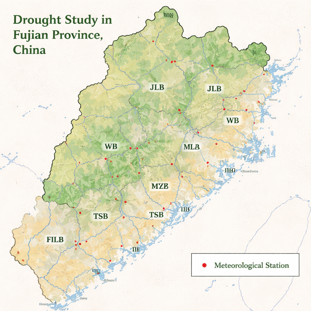
Instead of relying only on rain gauges and weather stations, the researchers treated Fujian as a living, breathing landscape that can be monitored from orbit. They divided the province into 11 river basins, from the large Minjiang system in the interior to smaller coastal rivers in the southeast. Using NASA satellite data processed on Google’s cloud-based Earth Engine platform, they tracked four different “drought health” indicators from 2000 to 2023. These indices combine information on how green the vegetation is and how hot the land surface feels, both of which change quickly when plants are stressed for water. By comparing these signals over time and space, the team could map which basins are usually moist, which tend to dry out, and how those patterns are shifting.
Where the land dries out first
The satellite record paints a clear picture: most of Fujian has stayed largely free of serious drought over the past two decades, but the southeastern coastal plains regularly flirt with trouble. Basins such as Jinjiang, Jiulong, Mulan, and the southeastern coastal rivers show frequent mild to severe drought conditions, while the more rugged inland basins remain relatively resilient. In 2005, a province-wide dry year, more than three-quarters of the area showed signs of drought in at least one index. Yet when the team looked at long-term trends, they found that conditions have generally improved since 2000, especially after 2013. In nearly half the province, vegetation-based indices show a statistically significant easing of drought, likely reflecting ecological restoration, reforestation, and better land management.
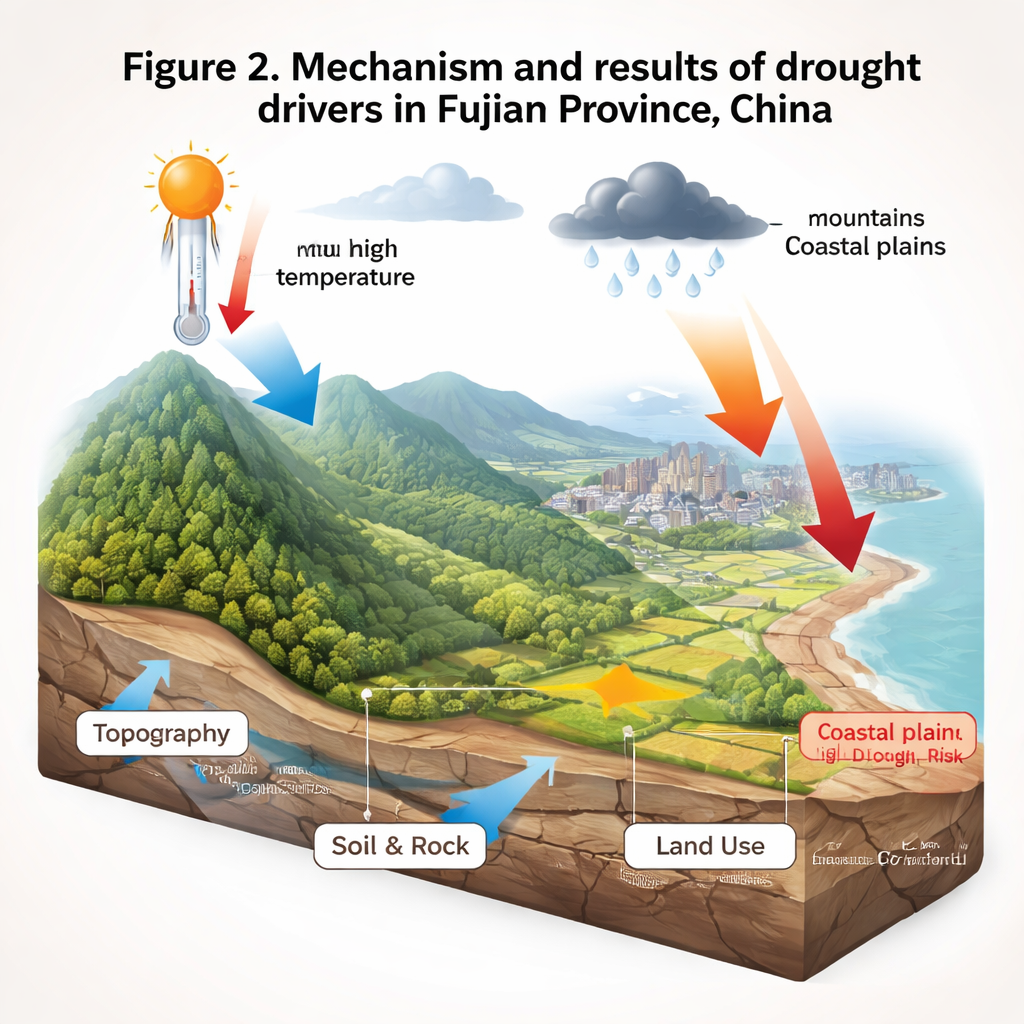
Heat, hills, soils, and cities as hidden drivers
To move beyond simple maps of dry and wet years, the authors asked what physical features make some places more drought-prone than others. They compared the drought indices with temperature, rainfall, elevation, slope, soil, bedrock, and land cover. Surprisingly, temperature often correlates positively with the satellite drought scores: in Fujian’s humid climate, warmer years frequently coincide with vigorous plant growth because heat and moisture tend to arrive together. Rainfall, by contrast, showed weaker and more complicated links. The landscape itself proved crucial. Forested mountains and hills, with deeper soils and fewer paved surfaces, generally held up well during dry spells. Bare ground, cropland with sparse cover, and urban areas with lots of concrete lost water quickly and showed the lowest drought index values. Loose river and coastal sediments and certain soil types also drained rapidly, leaving plants more vulnerable between storms.
Choosing the right tool to watch for trouble
Because each drought index highlights slightly different aspects of water stress, the team tested how well they performed in Fujian’s mix of mountains and coasts. Two indices that lean heavily on vegetation “greenness” tended to underplay drought in hilly, forested areas but worked well on the low-lying coastal plains. Two others, which emphasize land surface temperature, sometimes exaggerated drought along the hot, built-up coast but better captured stress in the interior basins. The authors suggest pairing these tools in a basin-by-basin way: using greenness-based indices to monitor plains and cities, and temperature-based indices to keep an eye on rugged, forested terrain. This tailored approach could sharpen early warning systems and make regional drought assessments more reliable.
What this means for people and planning
For residents and planners in Fujian, the study offers both reassurance and a warning. On one hand, thanks to abundant rain and major efforts to restore forests and protect ecosystems, long-term drought risk across much of the province has eased rather than worsened, despite rising temperatures. On the other hand, the work shows that certain coastal basins—where cities are growing fast, fields are exposed, and soils are quick to drain—remain clear hot spots for future drought. By combining satellite monitoring with knowledge of local land use, soils, and terrain, officials can target these vulnerable basins for greener cities, smarter farming, and better water storage. In short, staying ahead of drought in a humid province is less about chasing every dry year and more about understanding how climate and landscape together shape where the land runs dry first.
Citation: Wu, Z., Wang, J., Chen, Y. et al. Identifying the spatio-temporal pattern and driving factors of drought in Fujian Province, China. Sci Rep 16, 7089 (2026). https://doi.org/10.1038/s41598-026-37602-y
Keywords: drought, remote sensing, Fujian Province, river basins, land use