Clear Sky Science · en
Automatic identification and feature analysis of Min-ing-Induced surface cracks using an improved DRA-UNet
Why tiny ground cracks matter
Across the world’s coalfields, underground mining can quietly tear open the land above. What first appears as hairline fractures in dry soil can grow into long surface cracks that channel rainwater, undermine roads, and even trigger landslides or building damage. Inspecting these cracks on foot is slow, dangerous, and easy to miss. This study shows how drones and artificial intelligence can automatically spot and measure mining‑induced cracks in great detail, offering a powerful new tool for keeping mining regions safer and more sustainable.
Seeing more from the air
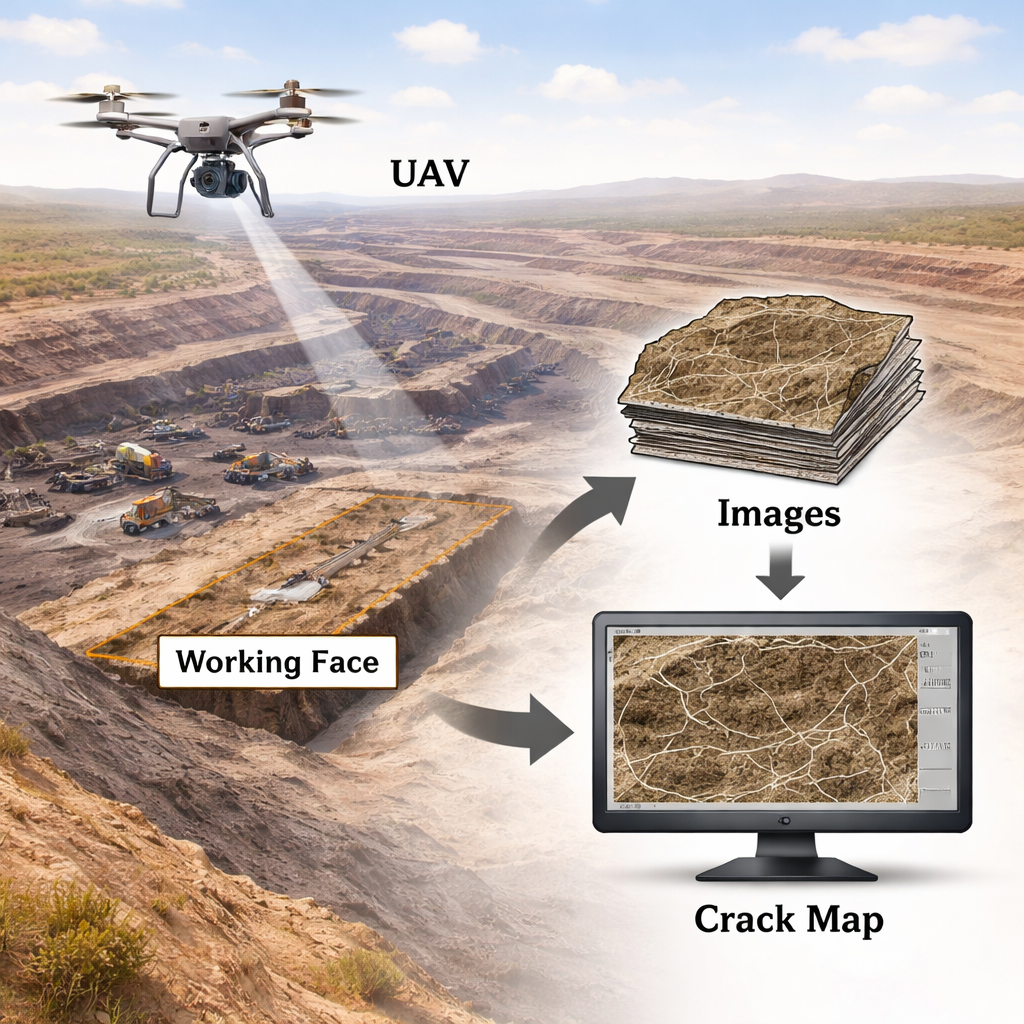
The researchers focused on the Huojitu Coal Mine on the edge of China’s Mu Us Desert, where underground coal extraction has produced a complex web of surface fractures. They flew an industrial quad‑rotor drone equipped with a high‑resolution camera over the mining face, capturing images sharp enough to resolve features just under three centimeters across. After correcting the images for geometry and brightness, they stitched them into detailed overhead maps. Human interpreters then carefully traced visible cracks, creating thousands of labeled examples that would teach the computer what to look for in similar scenes.
Teaching a neural network to follow hairline fractures
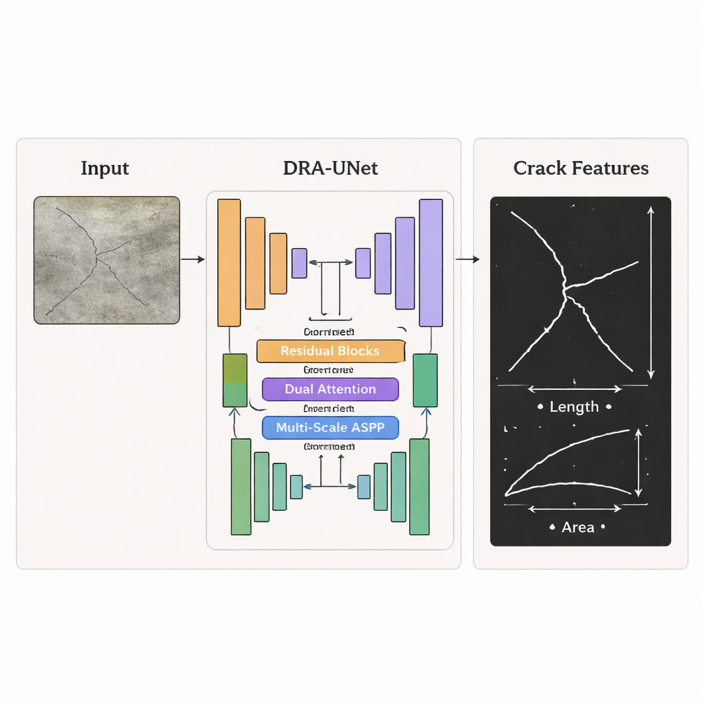
At the heart of the work is an improved image‑analysis system called DRA‑UNet, a type of deep neural network originally designed for medical image segmentation. The model examines each drone image tile and decides, pixel by pixel, whether it belongs to a crack or to intact ground. The team upgraded the classic architecture with three key ideas: residual connections that make it easier to train a deep network, a dual‑attention module that helps the system focus on the most informative patterns in both space and color channels, and a multi‑scale module that looks for cracks of many different widths at once. A specially designed loss function further pushes the network to avoid missing thin cracks and to trace their edges cleanly.
From crack maps to measurable shapes
Once the model produces a black‑and‑white crack map, the study goes a step further. A thinning algorithm strips away border pixels until only the central “skeleton” of each crack remains, like the midline of a dried riverbed. Using this skeleton, the researchers compute each crack’s length, average width, area, direction, and how rectangular or irregular its outline is. These measurements are converted from pixels into real‑world units using the known ground resolution of the images. By assigning each crack a unique ID and bounding rectangle, the team can compare shapes, track how cracks grow, and relate them to the mine’s layout and direction of advance.
What the crack patterns reveal about the mine
Tests showed that the improved DRA‑UNet outperformed several well‑known image‑segmentation models on the mining‑area dataset and also generalized strongly to a separate benchmark of road and pavement cracks. It was especially good at preserving thin, faint fractures under cluttered backgrounds of gravel, vegetation, and shadows. The resulting measurements reveal clear trends: most cracks are short, narrow, and small in area, with a few long ones forming the main framework that guides ground deformation. Near the working‑face boundaries, crack density and complexity increase, matching zones of higher stress. Short cracks tend to be more twisted and branched, while longer ones straighten out along the dominant stretching direction, showing how local disturbances give way to broader stress fields as mining progresses.
How this helps keep mining areas safer
For non‑specialists, the key message is that tiny surface cracks are early warning signs of deeper changes in the ground above mines. This study demonstrates an automated way to find and measure those cracks from the air with high precision, without sending inspectors into hazardous zones or relying on slow manual mapping. By combining drone images, smart neural networks, and shape analysis, the framework can highlight where damage is concentrated and how it is evolving over time. In practical terms, that means mine operators and local authorities can monitor large areas more often, better anticipate ground failures, and plan mitigation efforts to protect infrastructure, ecosystems, and communities living above active coal seams.
Citation: Zhou, W., Zou, Y. & Chai, H. Automatic identification and feature analysis of Min-ing-Induced surface cracks using an improved DRA-UNet. Sci Rep 16, 6591 (2026). https://doi.org/10.1038/s41598-026-37548-1
Keywords: mining-induced surface cracks, UAV crack mapping, deep learning segmentation, ground deformation monitoring, geotechnical hazard assessment