Clear Sky Science · en
A scenario-based framework for spatial assessment of multi-source renewable energy parks: a case study of Makran region in Iran
Why this coastal region matters for clean power
The world is racing to replace fossil fuels with cleaner energy, but deciding exactly where to put new solar panels, wind turbines, and geothermal plants is far from simple. This study takes on that challenge for the Makran coast in southeastern Iran—a sunny, windy, geologically active region on the Oman Sea—by building a detailed map-based planning tool. The framework they develop is meant to help governments and investors choose sites that deliver the most energy, cost the least, and do the smallest harm to people and nature.
Turning a complex coastline into a living energy lab
Makran is a vast coastal strip stretching along the Oman Sea, home to ports like Chabahar and towns scattered between mountains and shoreline. It offers strong sunshine, steady seasonal winds, and underground heat, all of which could supply electricity and jobs to an underdeveloped region. Yet, despite this natural wealth, Iran’s renewable capacity has grown slowly compared to global trends, and Makran itself has seen only modest investment. The authors argue that one barrier is the lack of integrated studies that look at several renewable sources together, rather than in isolation, and that account for both local conditions and uncertainty in planning choices.
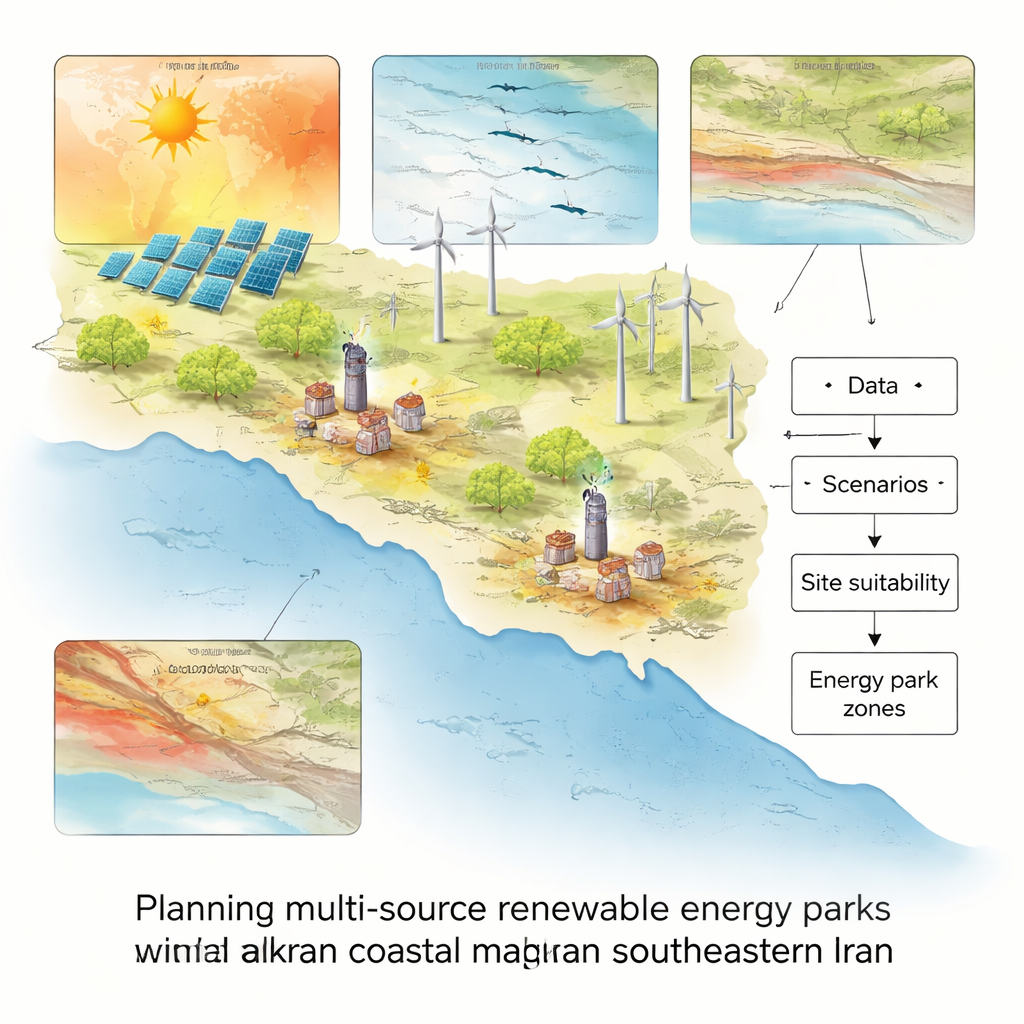
Building an intelligent map for clean energy
The researchers assembled a large set of geographic and energy-related data for Makran, including maps of solar radiation, wind speed and power, land surface temperature, faults and geothermal features, elevation and slope, dust and vegetation, rainfall, and the location of roads, cities, ports, and power lines. They also marked places where energy projects should not go at all, such as protected areas, wetlands, airports, and farmland. Altogether they used 22 evaluation criteria and 16 exclusion rules. Each map layer was converted to a common scale from 0 (worst) to 1 (best) so that very different kinds of information—like distance to a road or strength of the wind—could be combined in a single analysis.
Weighing choices and testing different futures
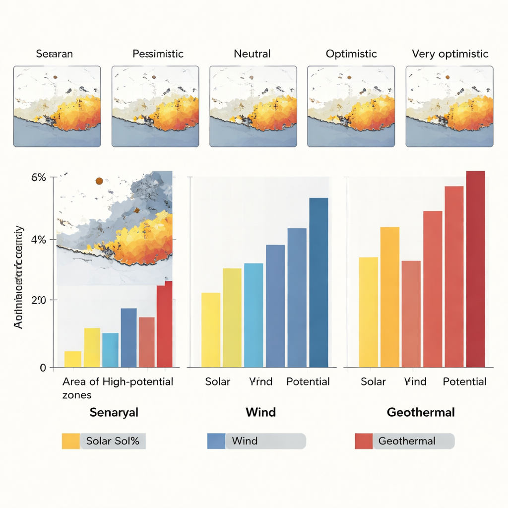
Because not all factors matter equally, the team used a structured expert-based method to assign weights, while checking for internal consistency so that the final numbers were as reliable as possible. For example, solar output potential and dust levels were especially important for solar sites, wind speed and wind power for wind farms, and proximity to warm, geologically active zones for geothermal plants. To reflect different attitudes toward risk and uncertainty, they then applied an approach called ordered weighted averaging. This allowed them to run five decision “scenarios,” from very pessimistic (favoring only areas strong on every factor) to very optimistic (willing to accept more trade-offs), without changing the underlying data.
Where solar, wind, and underground heat can work together
Running these scenarios produced detailed suitability maps for each energy source and for their combinations. Counties like Chabahar and Konarak consistently emerged as prime candidates for both solar and wind, while Jask and Sirik stood out for geothermal energy. As the scenarios shifted from very pessimistic to very optimistic, the share of land rated as very high potential grew markedly: from about 9% to 20% for solar, from 9% to nearly 24% for wind, and from about 11% to 30% for geothermal. At the same time, the area considered flatly unsuitable shrank, and regions where all three resources overlapped expanded roughly fourfold. These “triple-win” zones are especially attractive for building multi-source renewable parks that can balance each other over seasons and weather conditions.
What this means for people and policy
In simple terms, the study shows that Makran has more room for clean, reliable energy than current development patterns suggest—especially if planners are willing to consider a range of reasonable futures instead of planning only for the worst case. By combining many kinds of geographic and environmental information into a single, scenario-based map, the framework helps identify locations where solar, wind, and geothermal projects can be built together with lower risk and higher payoff. The authors propose that this approach can guide smarter investment, reduce dependence on fossil fuels, and support local jobs and resilience in Makran and other coastal regions facing similar choices about their energy future.
Citation: Sazvar, Z., Shorabeh, S.N., Mahmoodi, H. et al. A scenario-based framework for spatial assessment of multi-source renewable energy parks: a case study of Makran region in Iran. Sci Rep 16, 6406 (2026). https://doi.org/10.1038/s41598-026-37474-2
Keywords: renewable energy mapping, solar and wind potential, geothermal resources, energy planning Iran, spatial decision tools