Clear Sky Science · en
Assessing reservoir heterogeneity using the turbulence factor as an effective tool for hydraulic flow unit classification for BM-85 Well, Gulf of Suez, Egypt
Why rock layers beneath the Red Sea matter
Beneath the waters of Egypt’s Gulf of Suez, thin layers of sand and mud control whether an oil field keeps producing or runs dry. Even in wells that look promising on paper, some rock layers let oil flow freely while others stubbornly block it. This article explores a new way to sort these hidden layers in a single well, BM‑85, by looking not just at how porous the rocks are, but at how chaotically fluids move through their tiny passageways.
A challenging underground patchwork
The study focuses on the Lower Senonian Formation, a package of rocks that sits deep below the Gulf of Suez. This region is famous among geologists for its broken, faulted structure and rapidly changing rock types. Instead of a simple, uniform layer cake, the reservoir behaves more like a patchwork quilt stitched from sands, marls, and thin shales. These variations—known as reservoir heterogeneity—strongly influence how oil, gas, and water move underground and can make the difference between efficient production and stranded resources.
Peering into the rocks with cores and logs
To untangle this complexity, the authors combined two kinds of evidence. First, they examined 103 small cylindrical rock samples, or cores, taken between about 3.4 and 3.5 kilometres below the surface. Laboratory tests measured how much empty space these samples contained (porosity) and how easily fluids could pass through them (permeability). Second, they analysed continuous measurements recorded by tools lowered into the well—gamma ray, density, neutron, sonic, and resistivity logs—to map changes in rock type and fluid content along the full depth. By matching the core results to the log responses, they could extend detailed rock information far beyond the few places where cores were available. 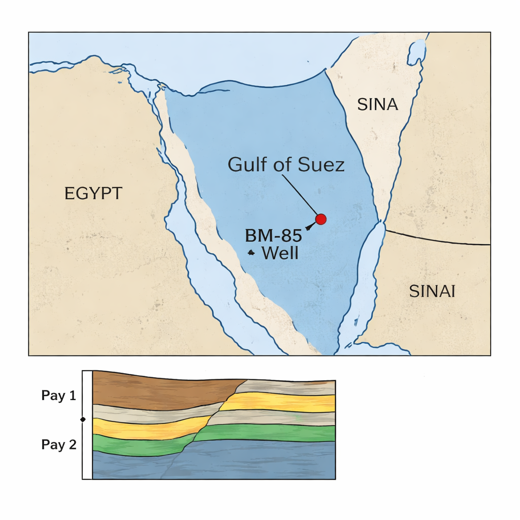
Finding the sweet spots for production
Using this integrated dataset, the team identified two main “pay zones” that are capable of producing hydrocarbons. Pay 1, the upper interval, shows moderate porosity around 21 percent and a relatively high oil saturation of about 63 percent, but only modest flow capacity. Pay 2, the lower interval, stands out as an excellent reservoir: laboratory measurements reveal very high average permeability, in the hundreds of millidarcies, with effective porosity between 18 and 21 percent. Together, these numbers indicate rock that not only stores oil but also lets it move readily toward a well. However, the range of measured permeabilities—from almost sealed to extremely open—confirms that even within these pay zones, the reservoir is far from uniform.
When flow stops being smooth
Traditional evaluations mainly link porosity and permeability, but this study goes a step further by considering how fluid flow becomes irregular at higher speeds or in complex pore systems, a behaviour called non‑Darcy flow. The authors use a quantity known as the turbulence factor, symbolised by β, which rises when fluid paths twist and turn through narrow or tortuous pores. By calculating β from each core’s permeability and plotting it against a combined porosity‑permeability measure called the Reservoir Quality Index (RQI), they separated the rock into two hydraulic flow units. One group has high RQI and low β, indicating well‑connected, “smooth‑flowing” pathways. The other shows low RQI and high β, pointing to tighter, more chaotic pore structures that restrict movement even if porosity looks acceptable on paper. 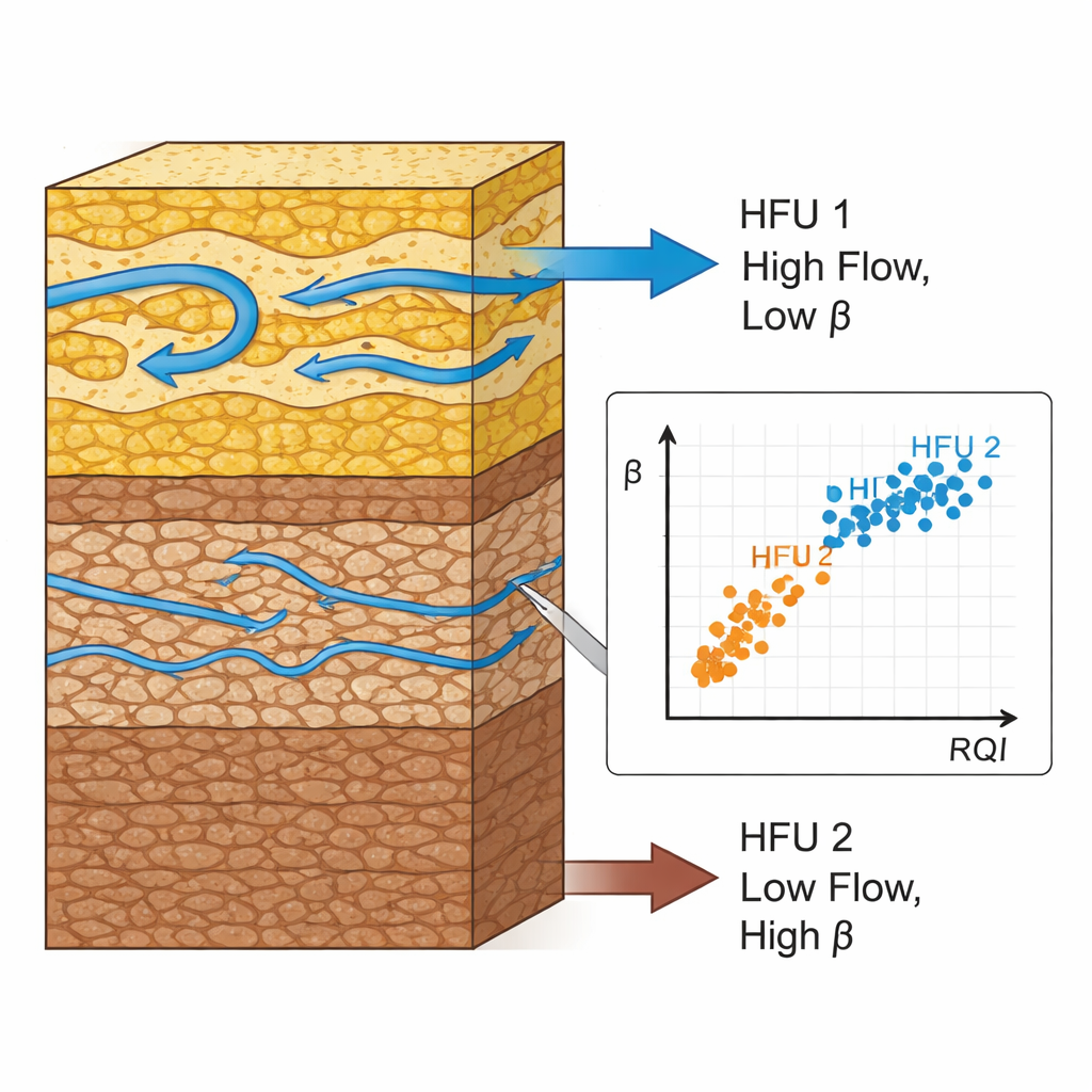
Connecting pore sizes to flow behavior
To see why these differences arise, the team estimated pore‑throat sizes—the narrow necks between larger pores—using special laboratory techniques and established equations. Rocks dominated by larger pore throats (macro‑ and megapores) tend to have high permeability and low turbulence factors, making them prime targets for production. In contrast, rocks with mainly very small pore throats act as tight reservoirs: they store fluids but release them reluctantly, and show high β values that signal strong resistance to flow. Additional analysis of how storage capacity and flow capacity vary with depth reveals that a few high‑permeability streaks carry most of the flow, while thicker but tighter layers mainly act as storage.
What it all means for producing more oil
Seen from a non‑specialist’s viewpoint, the study shows that not all “good‑looking” rock is equal. Two layers with similar porosity can behave very differently if one has open, well‑connected pores and the other is clogged by cement or clays. By adding the turbulence factor to standard measurements, the authors provide a more realistic picture of which parts of the reservoir actually deliver oil efficiently. In BM‑85, Pay Zone 2 lines up with the best hydraulic flow unit, while Pay Zone 1 corresponds to a more modest, but still productive, unit. This approach—marrying core tests, well logs, pore‑size estimates, and β‑based flow units—offers operators in the Gulf of Suez and similar fields a sharper tool for pinpointing the sweetest spots, planning waterfloods, and ultimately recovering more hydrocarbons from complex underground landscapes.
Citation: Al-Alfy, I.M., El-Sawy, M.Z., Salama, N.S. et al. Assessing reservoir heterogeneity using the turbulence factor as an effective tool for hydraulic flow unit classification for BM-85 Well, Gulf of Suez, Egypt. Sci Rep 16, 7185 (2026). https://doi.org/10.1038/s41598-026-37379-0
Keywords: reservoir heterogeneity, Gulf of Suez, hydraulic flow units, turbulence factor beta, pore throat size