Clear Sky Science · en
Role of Arabian Sea warm pool and atmospheric instability in triggering a monsoonal MCC over Peninsular India
Why this storm matters
In late July 2024, a ferocious overnight rainstorm unleashed deadly landslides in Wayanad, a hilly district on India’s southwest coast. Behind this tragedy was not a cyclone, but a vast, long‑lived thunderstorm system called a Mesoscale Convective Complex—a kind of organized cloud cluster that can dump huge amounts of rain in a short time. This study unpacks why that system formed, how a patch of unusually warm Arabian Sea water helped fuel it, and what it may signal for future monsoon extremes as the Indian Ocean continues to warm.
A giant storm engine over the hills
The authors focus on a single event: 29–30 July 2024, when Wayanad in the Western Ghats saw exceptional rainfall, building on a recent run of flood‑rich monsoon seasons in Kerala. Using satellite estimates from NASA’s Global Precipitation Measurement mission and India’s dense rain‑gauge network, they show that daily rainfall exceeded 90 millimeters over a broad region and topped 150 millimeters in several locations, with one station near a dam measuring about 120 millimeters. Compared with typical July conditions, the region experienced sharply positive rainfall anomalies, confirming that this was not just another wet day in the monsoon, but a standout extreme.
Tracking a monster cloud system
Infrared images from the new INSAT‑3DS weather satellite reveal the evolution of the storm system itself. On the morning of 29 July, a large area of very cold cloud tops—signaling tall, deep thunderclouds—began to expand over the southeastern Arabian Sea. By evening and into the early hours of 30 July, the cloud shield spread over hundreds of thousands of square kilometers and maintained its size and shape for more than 12 hours while drifting inland toward the Western Ghats. These characteristics match classic criteria for a Mesoscale Convective Complex: a huge, long‑lived cluster of thunderstorms that organizes into a single storm engine capable of sustained, intense rain.
Hidden workings in the air above
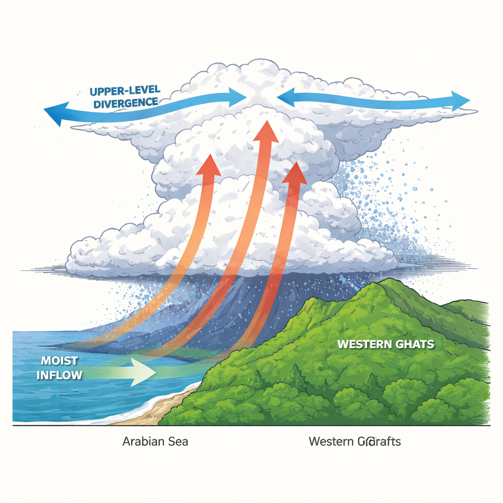
Reanalysis data, which blend many observations into a consistent picture of the atmosphere, show that the storm grew in a highly favorable environment. Throughout the event, the entire air column over Kerala and the nearby sea was unusually moist, with strong inflow of water vapor near the surface and pronounced rising motion over the coast and hills. Higher up, air spread outward, a pattern known as upper‑level divergence that helps sustain thunderstorm towers. The study also finds stronger‑than‑usual wind shear—winds changing with height—which helps organize and ventilate large storm complexes. Cloud‑microphysics data indicate increased liquid water and ice aloft, consistent with tall storm towers that efficiently convert moisture into heavy rain.
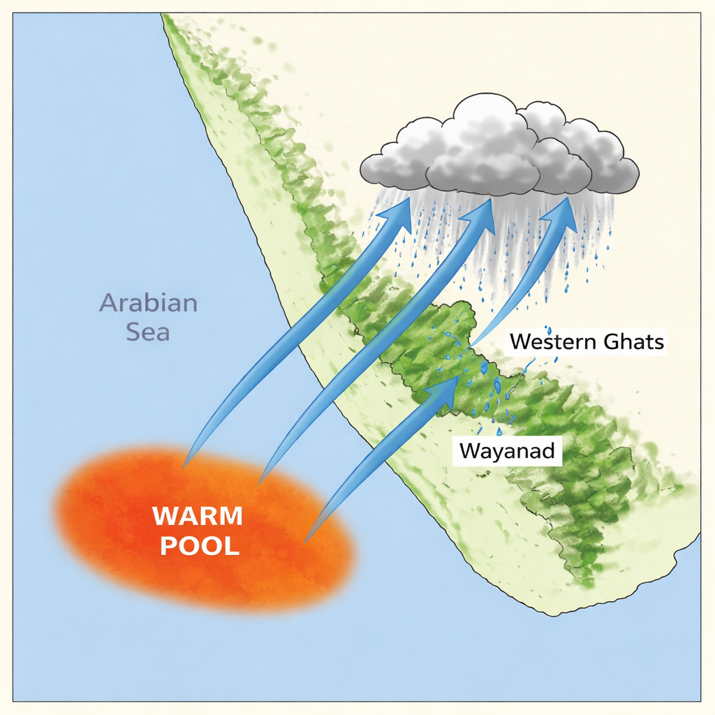
A warm patch in the sea as silent fuel
To explain the deep reservoir of moisture, the authors look seaward. In the days leading up to the disaster, the southeastern Arabian Sea hosted a “mini warm pool”—a patch of sea surface more than 1 °C warmer than normal that lingered for four to five days. At the same time, surface air pressure over this region was lower than usual, signaling that the warm water was destabilizing the air above it. Estimates of latent heating, derived from satellite rainfall profiles, show an intense focus of heat release between about 2 and 4 kilometers altitude on 29 July, with less of the layered, stratiform rain that typically spreads heating higher up. Taken together, these signs point to vigorous, tall convective clouds fed directly from the warm pool and streaming toward the Western Ghats.
What this means for people and forecasts
The study concludes that the Wayanad disaster was the product of a powerful combination: an unusually warm Arabian Sea patch that kept the lower atmosphere moist and unstable, and large‑scale wind patterns that organized and sustained a massive storm complex over steep terrain. As the Arabian Sea continues to warm and marine heatwaves become more common, such ocean‑fed storm clusters may become both more frequent and more intense. For people living along India’s west coast, this raises the stakes for accurate early‑warning systems and for weather models that can capture these mesoscale storm structures over mountains. In simple terms, hotter seas can load the dice toward more devastating overnight deluges, making better monitoring and preparedness essential.
Citation: Jose, S., Jayachandran, V. & Pradeep, N.S. Role of Arabian Sea warm pool and atmospheric instability in triggering a monsoonal MCC over Peninsular India. Sci Rep 16, 7121 (2026). https://doi.org/10.1038/s41598-026-37219-1
Keywords: Arabian Sea warm pool, Indian monsoon extremes, Western Ghats rainfall, mesoscale convective complex, Kerala floods