Clear Sky Science · en
Satellite-based oil spill detection using an explainable ViR-SC hybrid deep learning ensemble for improved accuracy and transparency
Why spotting oil from space matters
When an oil tanker leaks or a well blows out, thick black slicks can spread across the ocean in hours, killing wildlife and damaging coasts for years. Today, much of the world’s early warning system relies on satellites that scan the sea surface day and night. But these images are noisy and cluttered, and natural phenomena can easily masquerade as spills. This study presents a new satellite-analysis system, called ViR-SC, that not only detects oil spills more accurately than previous methods but also shows human operators why it made each decision.
Seeing spills in a noisy ocean
The work focuses on images from Sentinel-1, a radar satellite that measures microwave reflections from the sea. Real oil slicks usually appear as dark streaks because they calm tiny surface waves, reducing the radar signal. Unfortunately, many harmless conditions—like patches of very smooth water, natural films from algae, or changes in wind—also look dark. On top of that, radar images are speckled with grainy noise that can hide or imitate slicks. Earlier systems tried to clean up this noise and classify dark spots using hand-crafted rules or single machine-learning models, but they often struggled when conditions changed.
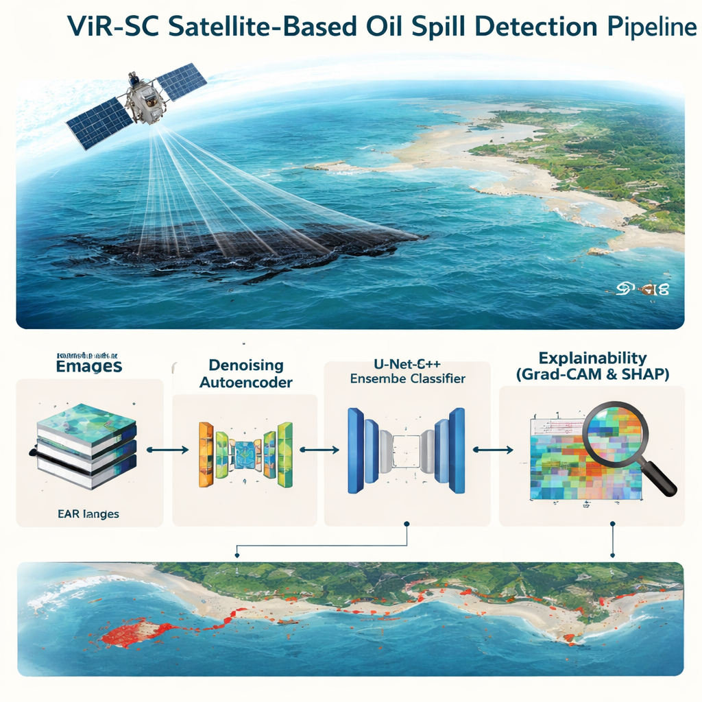
Cleaning and outlining suspect regions
The ViR-SC approach starts by improving the pictures themselves. A “denoising autoencoder,” a type of neural network trained to reconstruct clean images from noisy ones, learns how real sea patterns look and suppresses the random speckle without erasing thin or faint slicks. Next, a second network called U-Net++ produces rough masks that highlight regions where something unusual is happening on the water surface. Even though the dataset lacks perfect, hand-drawn spill outlines, the model is trained in a weakly supervised way to emphasize low-reflection zones, providing a kind of spotlight for later decision stages.
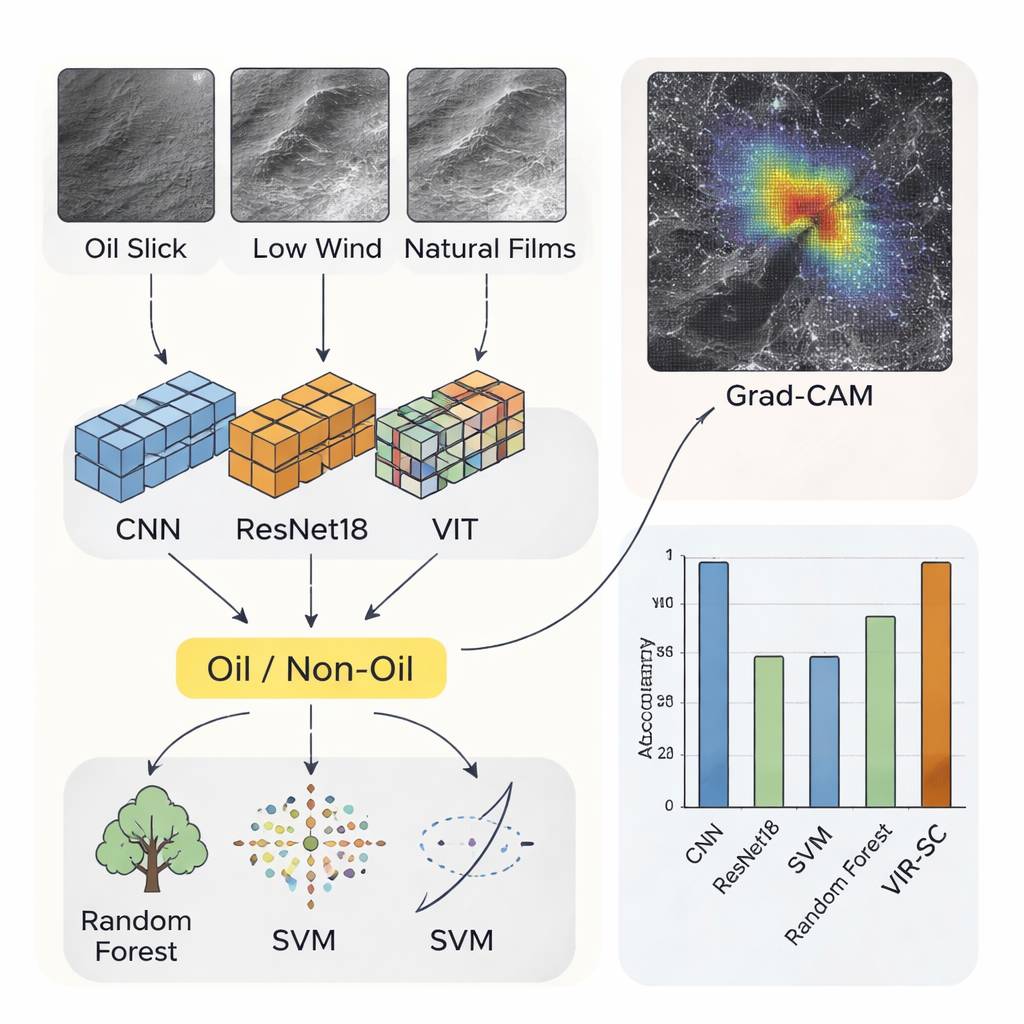
Many minds deciding together
After denoising and rough localization, ViR-SC brings several different classifiers to bear on each small image patch. Three are deep-learning models: a conventional convolutional neural network that picks up local textures, a ResNet18 model that learns deeper, layered patterns, and a Vision Transformer that excels at capturing long-range structure across the whole patch. Two more are classic machine-learning algorithms: Random Forest, which makes decisions based on many shallow decision trees, and Support Vector Machine, which draws sharp boundaries between classes. Each model votes on whether a patch contains oil or not, and the majority decision becomes the final answer. Tested on a public dataset of more than 5,600 labeled radar patches, the best single model (the Vision Transformer) reached 98.0% accuracy, while the combined ViR-SC ensemble edged higher to 98.45%, with very low false-alarm and miss rates.
Opening the black box
Accuracy alone is not enough for agencies that must justify costly cleanup efforts. The authors therefore built explainability directly into ViR-SC. For the deep networks, they use a technique called Grad-CAM to create colored heatmaps over each radar patch, showing which pixels most influenced a “spill” prediction. In successful cases, the brightest regions align tightly with the actual dark slick, not with random background. For the Random Forest classifier, the team applies SHAP, a method that assigns each pixel a positive or negative contribution to the final decision. Together, these tools let human analysts see whether the system is focusing on plausible spill structures or being fooled by unrelated patterns, improving trust and aiding expert review.
What this means for ocean protection
To a non-specialist, the main takeaway is that ViR-SC is a more reliable and transparent “eyes in the sky” for oil spills. By first cleaning radar images, then sketching out suspicious patches, and finally fusing the judgments of multiple complementary models, it detects spills slightly better than any single method on its own. Just as important, it can explain its reasoning through visual overlays rather than offering a mysterious yes-or-no answer. With further tuning for speed and broader testing on different seas and seasons, systems like ViR-SC could help authorities spot real spills faster, ignore harmless look-alikes, and respond more confidently to protect marine ecosystems and coastal communities.
Citation: Murugan, J.S., Ramkumar, K., Kshirsagar, P.R. et al. Satellite-based oil spill detection using an explainable ViR-SC hybrid deep learning ensemble for improved accuracy and transparency. Sci Rep 16, 6637 (2026). https://doi.org/10.1038/s41598-026-37081-1
Keywords: oil spill detection, satellite radar, deep learning, ensemble methods, explainable AI