Clear Sky Science · en
Study on the maximum penetration depth of GPR based on soil electromagnetic properties
Seeing Underground Without Digging
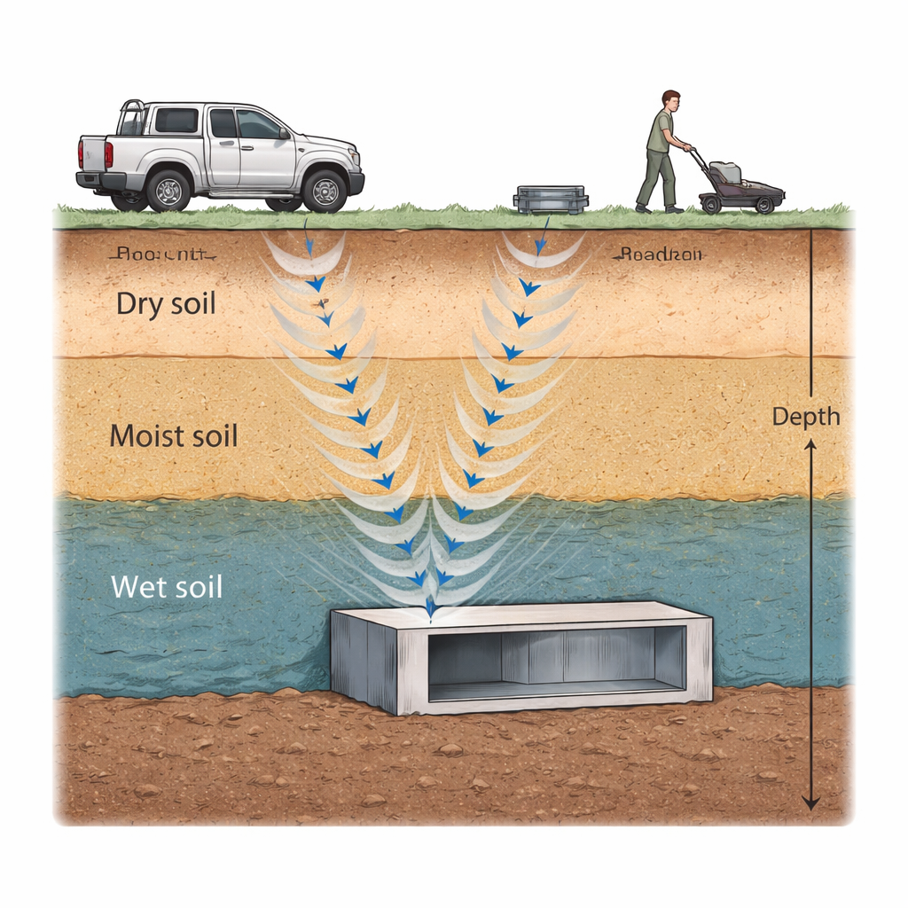
From locating hidden tunnels to checking the health of roads and runways, engineers increasingly rely on ground‑penetrating radar (GPR) to "see" underground without excavation. But GPR does not work equally well everywhere: in some places its signals reach more than a meter below the surface, while in others they fade after only half that distance. This study asks a simple but crucial question for planners, geologists, and defense engineers: how deep can radar really see into different kinds of soil, and what controls that limit?
Why Soil Matters for Underground Scanning
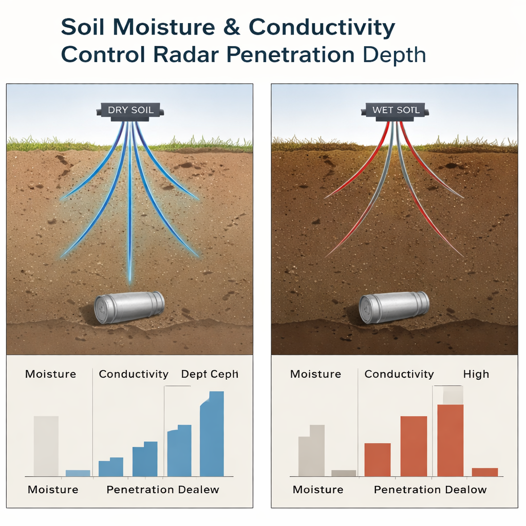
When a radar system sends short radio pulses into the ground, the soil itself becomes part of the instrument. The electrical properties of the soil—how easily it stores and loses electromagnetic energy—govern how fast the waves travel and how quickly they fade. These properties depend strongly on moisture and dissolved salts. Dry, sandy ground tends to let radar waves pass with modest loss, while wet, mineral‑rich soil acts more like a sponge, soaking up energy and shrinking the useful viewing depth. Because China spans climates from desert to monsoon forest, the authors chose it as a natural laboratory to examine how soil from arid to humid regions changes GPR performance.
Measuring How Soils Behave Under Radar
The team collected six representative soil types from across China, including loess from the northwest, Gobi soil, northeast black soil, and moist coastal soils in the southeast and Guangdong. In outdoor tests they used an ultra‑wideband time‑domain radar system, together with a commercial time‑domain reflectometer probe, to measure two key quantities across 300 MHz to 4 GHz—the same frequency range used by many practical GPR and synthetic‑aperture radar systems. One quantity, the real part of the dielectric constant, tells how strongly the soil interacts with the radar field; the other, closely tied to electrical conductivity, tracks how quickly the wave energy is absorbed and turned into heat. By adjusting water content in carefully prepared samples, they directly mapped how moisture raises conductivity and changes these dielectric properties.
From Dry Dust to Wet Clay
The measurements reveal a clear progression from dry to wet landscapes. As the climate shifts from arid northwest to humid southeast, soil moisture content in the samples increases about 2.7‑fold, the real part of the dielectric constant grows by roughly 1.6 times, and electrical conductivity rises by about one‑third. Within a given site, deeper soil at 12 cm holds more water and shows 4–10% higher dielectric constant than the surface layer, confirming that depth subtly amplifies these effects. Electrical conductivity and dielectric constant climb almost linearly as water is added, reaching 300–550 μS/cm at 30% moisture. In parallel, the “lossy” part of the dielectric behavior—how strongly the soil damps the waves—drops with frequency but is consistently higher in wetter southern soils. Comparisons with the World Soil Database show that the new measurements align well with global reference values, increasing confidence that they can stand in for similar terrains.
Translating Soil Physics into Safe Digging Depths
To turn laboratory numbers into practical guidance, the authors built a mathematical model of radar waves traveling through stacked soil layers, each with its own measured properties. Using a transfer‑matrix method, they simulated how pulses reflect and weaken as they bounce between layers and off buried metal‑rich structures such as underground rooms or tunnels. They defined penetration depth in engineering terms: the deepest level at which echoes from a structure still stand out slightly above the natural “clutter” from rough ground and random inhomogeneities. Adopting a conservative signal‑to‑clutter threshold of 0.5 decibels—stricter than many earlier studies—they first validated their code against highway test data from the literature, then ran it with their Chinese soil measurements over the P‑ and L‑band frequency range.
What the Results Mean Above Ground
The simulations show that GPR penetration depth depends strongly on soil type. Under the same radar conditions, black soil in the northeast allows the deepest view, about 1.1 meters, while moist southeast soils cut the range to only about 0.5 meters. Across all tested sites, safe excavation depths inferred from radar signals span 0.5–1.1 meters. For most civil and military underground works, this means that structures at shallow depths can be surveyed and monitored reliably, but deeper facilities may require added shielding or different sensing methods to remain unseen or to be detected. By linking detailed soil measurements with a realistic penetration model, the study provides a practical roadmap for predicting how far GPR can see in varied terrains—and for planning underground projects and stealth measures accordingly.
Citation: Lu, S., Zhao, D., Qian, J. et al. Study on the maximum penetration depth of GPR based on soil electromagnetic properties. Sci Rep 16, 6265 (2026). https://doi.org/10.1038/s41598-026-36996-z
Keywords: ground penetrating radar, soil moisture, electromagnetic properties, radar penetration depth, underground engineering