Clear Sky Science · en
Assessment of land use transition, trend, shift & directional distribution in the Ganga Basin
Why this river basin matters to everyone
The Ganga Basin, stretching from the Himalayas to the Bay of Bengal, is home to hundreds of millions of people and underpins much of northern India’s food supply. Yet its landscape is being rapidly reshaped by farms, cities and industry. This study uses nearly three decades of satellite data to track how forests, fields, wetlands and towns have changed across the basin since 1992, and what that means for water, climate resilience and everyday life.
A crowded landscape under pressure
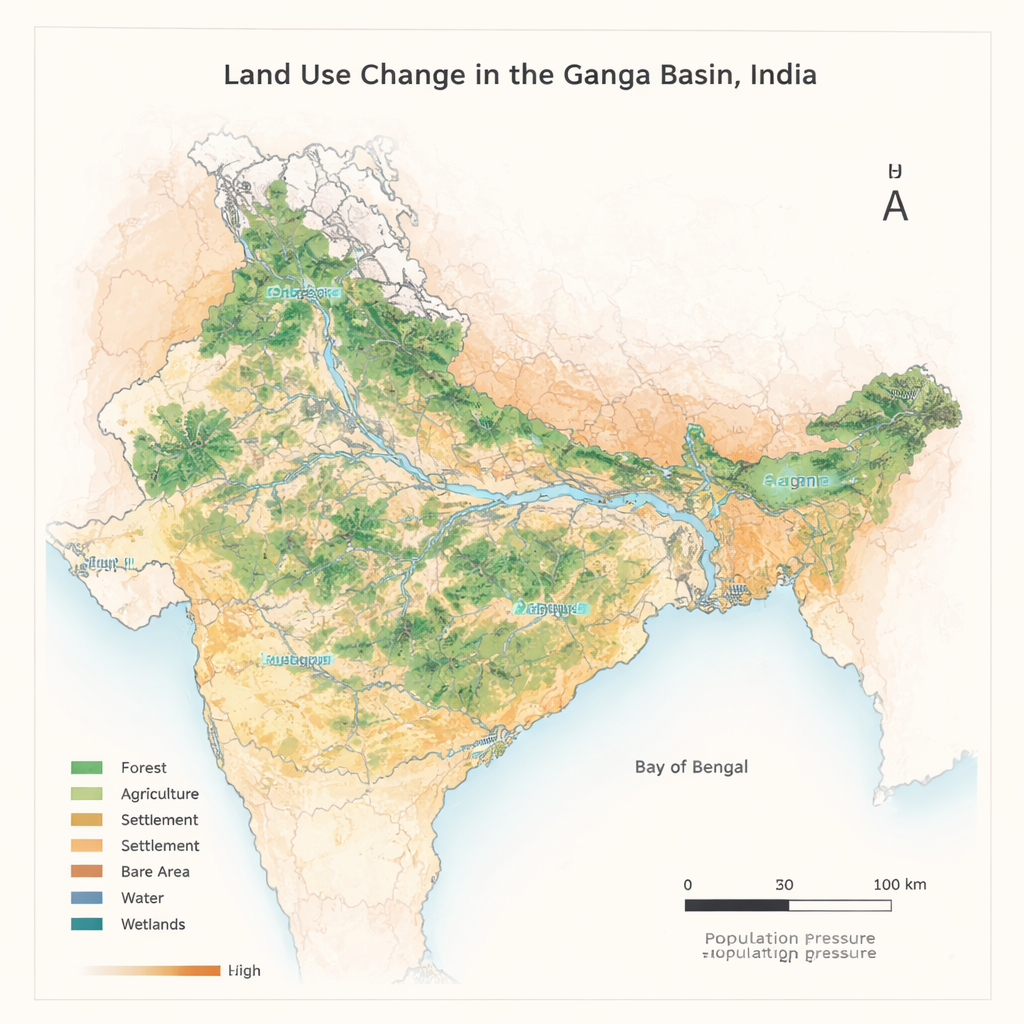
The Ganga Basin covers about 0.84 million square kilometers and includes some of the most densely populated districts on Earth. Most people depend directly or indirectly on agriculture, groundwater and natural ecosystems for their livelihoods. The authors show that in 2011 only a few districts experienced weak human pressure on land, while the vast majority were in the high or very high category, with more than 200 people per square kilometer. Under such pressure, even small shifts in how land is used can ripple through food production, flood risk, water quality and biodiversity.
Watching the land change from space
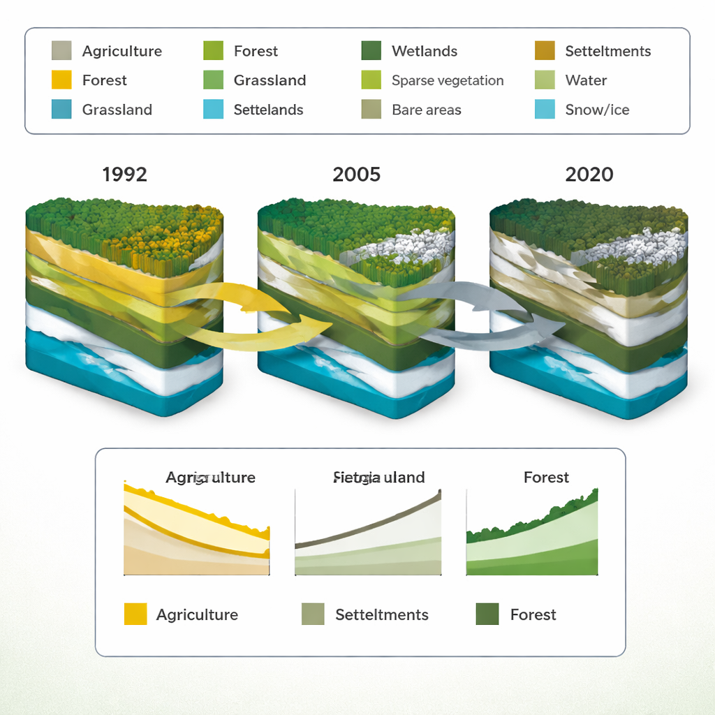
To understand these shifts, the researchers analyzed annual global land cover maps produced by the European Space Agency from 1992 to 2020, with a resolution of 300 meters. They grouped the original 22 land cover types into nine simple classes: agriculture, forest, grassland, wetland, settlement, sparse vegetation, bare area, water and snow/ice. Using a suite of statistical tools, they identified when abrupt changes occurred, how much area moved from one class to another, and in which direction the “center of gravity” of each land type drifted across the map. This approach allowed them to trace not just how much land changed, but also where and in what patterns.
Growing towns, shrinking fields and fading grasslands
The clearest story is the explosive growth of settlements. Built-up areas expanded by about 270.9 percent over the 29-year period, with the strongest shifts between 2002 and 2008. On average, settlement area increased by roughly 292 square kilometers every year. Much of this growth came at the expense of farmland and grasslands: agriculture shrank by about 406 square kilometers per year and grassland by about 38 square kilometers per year. Overall, grasslands declined by 8.14 percent, removing semi-natural habitats that help store water, support wildlife and buffer climate extremes. Forests, water bodies, bare areas and wetlands showed modest but significant increases, partly reflecting tree-planting efforts and reclassification of some sparsely vegetated land.
Shifting centers and hidden patterns
Beyond simple totals, the study reveals how the geography of land types has shifted. The mean “center” of settlements moved nearly 90 kilometers over the study period, while wetlands shifted by about 66 kilometers, indicating new urban hotspots and changing wet areas. Farmland, bare areas and forests also migrated, though less dramatically, while snow and ice remained essentially fixed. By examining how one land type converts into another, the authors found that the largest single flows were from agriculture to forest and from agriculture to settlements. Urbanization therefore competes directly with cropland, raising questions about long-term food security. Correlation analyses show that as settlements and forests expanded, agriculture and grassland tended to contract, highlighting tight links between development, conservation and farming.
What this means for people and policy
For non-specialists, the message is straightforward: the Ganga Basin is becoming more urban, less agricultural and poorer in natural grasslands, even as forests and wetlands gain some ground. These trends threaten goals such as ending hunger, protecting life on land and creating sustainable cities, all central to the United Nations’ 2030 Agenda. The authors argue that detailed, map-based tracking of land change should guide smarter planning—protecting key farmland, limiting sprawl, restoring wetlands and grasslands, and weaving risk reduction into land-use decisions. In a region where millions rely on the basin’s soils and waters, how the land is managed over the next few decades will strongly shape its environmental health and human well-being.
Citation: Hasan, M.S.U., Rai, A.K., Aldrees, A. et al. Assessment of land use transition, trend, shift & directional distribution in the Ganga Basin. Sci Rep 16, 6753 (2026). https://doi.org/10.1038/s41598-026-36879-3
Keywords: Ganga Basin, land use change, urbanization, remote sensing, sustainable development