Clear Sky Science · en
Spatiotemporal cropland dynamics and sustainable pathways in the Yangtze river economic belt
Why the fate of these fields matters to everyone
Along China’s Yangtze River, farms feed hundreds of millions of people while sharing space with booming cities and fragile wetlands. This study looks at how cropland in the Yangtze River Economic Belt has shifted over the past 20 years and what might happen by 2030. Its findings matter not only for China’s food supply but also for global debates about how to grow enough food without sacrificing rivers, forests, and climate stability.
One river, many competing demands
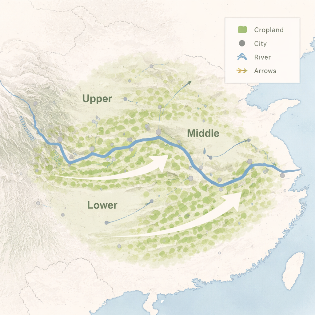
The Yangtze River Economic Belt stretches across 11 provinces, from steep western mountains to flat eastern plains. It contains about 40% of China’s cropland and produces more than a third of the nation’s grain. At the same time, it is home to some of China’s fastest-growing cities and key ecological reserves. The researchers combined detailed land-use maps from 2000, 2010, and 2020 with climate, terrain, and economic data to understand where cropland is being lost or gained, and what forces are driving those changes across the upper, middle, and lower reaches of the river.
How farms are changing shape and location
Over the last two decades, the overall area of cropland in the region has slowly declined, yet the pace at which land moves into and out of farming has stayed surprisingly balanced. The most common pattern is cropland being converted into built-up land such as cities, roads, and factories, while new cropland is carved out of water-related areas, including reclaimed wetlands or reservoirs. The “center of gravity” of cropland has shifted generally eastward and northward, reflecting the pull of more productive plains and development corridors. In mountain areas, many steep fields have been retired or converted to forest, while in lowland river and lake districts, farmers have intensified use of remaining flat land.
Local patterns: cities, climate, and transport
The study finds that cropland loss clusters around provincial capitals and expanding metropolitan zones like Chengdu, Wuhan, and the Yangtze River Delta. In some places, rapid early urban growth swallowed nearby fields, then slowed once protection rules tightened; in others, encroachment is increasing more recently. In the upper reaches, new highways and railways are a powerful trigger for converting fields to construction land. In the lower reaches, shifts in rainfall and temperature increasingly shape which areas remain suitable for farming. Across the belt, water bodies play a double role: they are often turned into cropland, yet they also stabilize the broader land-use system and are essential for long-term ecological health.
Looking to 2030: three different futures
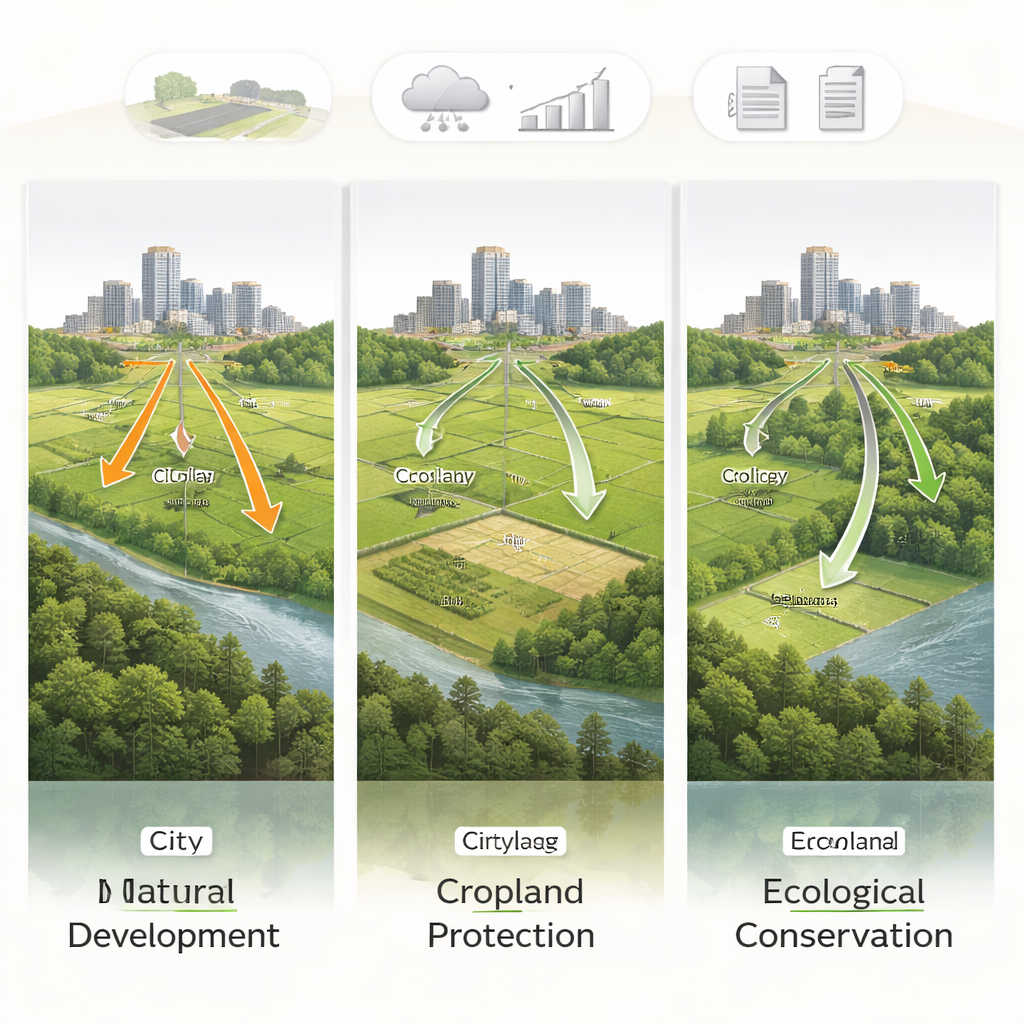
To explore what lies ahead, the authors used a land-use simulation model to test three scenarios for 2030. Under a “natural development” path that extends current trends, cities continue to push into farmland, and conflicts between urban space and agriculture intensify, especially in flat and coastal areas. A “cropland protection” path gives priority to safeguarding fertile fields, limiting their conversion and encouraging some grassland or marginal land to be upgraded for crops; only this scenario comes close to the cropland levels needed to meet China’s food security targets. An “ecological conservation” path places more land into forests, grasslands, and wetlands, improving environmental conditions but further tightening the supply of farmland, particularly in mountainous and lake-rich regions.
Finding balance between food, cities, and nature
For non-specialists, the main message is that securing food, thriving cities, and healthy ecosystems in the Yangtze region cannot be achieved with a one-size-fits-all policy. The authors argue that protecting key cropland near plains and river valleys, guiding urban growth within firm boundaries, and restoring fragile mountain and wetland ecosystems must happen together. Their analysis suggests that strong cropland protection policies, combined with smarter city planning and targeted ecological restoration, offer the most promising path to keep dinner tables full while keeping rivers flowing clean and landscapes resilient.
Citation: Wang, M., Hu, S., Sakradzija, M. et al. Spatiotemporal cropland dynamics and sustainable pathways in the Yangtze river economic belt. Sci Rep 16, 7698 (2026). https://doi.org/10.1038/s41598-026-36773-y
Keywords: cropland change, Yangtze River, urban expansion, food security, land use planning