Clear Sky Science · en
Dynamic rockfall risk assessment using multi-source data fusion and 3D simulation: a case study of Jiaohua rock
Why falling rocks matter to everyday life
In steep mountain regions, huge blocks of rock can suddenly break loose and race downhill, smashing homes, roads, and power lines in seconds. This study focuses on such rockfalls above a small village in China’s Three Gorges Reservoir area. By combining detailed field surveys, drone mapping, and advanced computer simulations, the researchers show how and where rocks are likely to move and how dangerous they can become—information that can help protect hundreds of residents living directly beneath unstable cliffs.
A village beneath a dangerous cliff
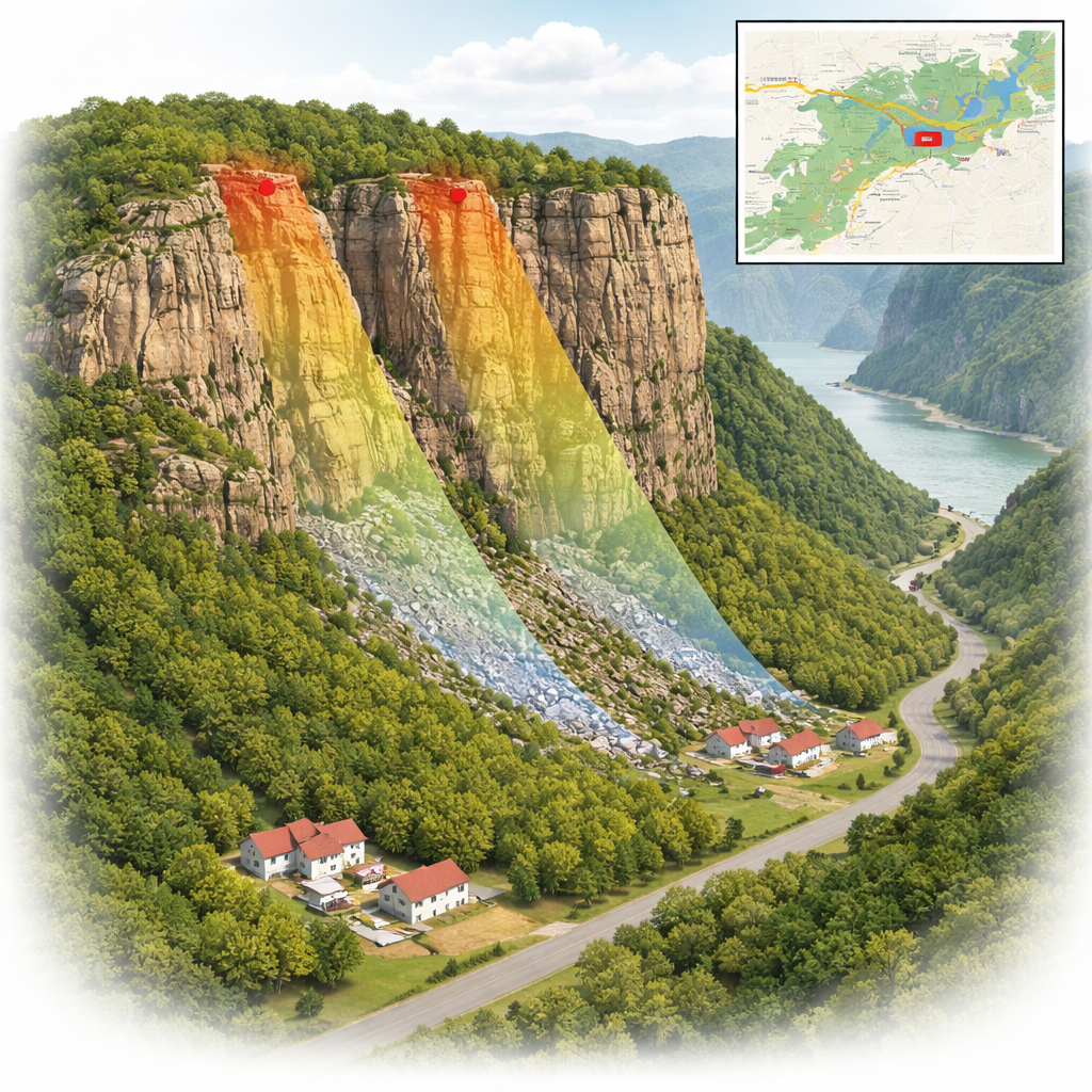
The Jiaohua Rock area sits in the Kaizhou District of Chongqing, about 300 kilometers upstream from the Three Gorges Dam. The landscape is a series of step-like sandstone cliffs separated by steep slopes and low, gentler platforms where people have built homes and roads. Heavy seasonal rains and complex rock layering have carved out tall rock faces above the village of Bao’an, where 48 households and a key rural road lie in the potential path of falling blocks. Since 2004, several rockfall incidents have already signaled that this is not a theoretical problem but a recurring threat.
How cracks set the stage for collapse
Field teams examined the cliff in detail and found six main zones of unstable rock, labeled WY1 through WY6, perched high on the first cliff level. The sandstone is generally strong, but it is cut by a network of cracks and joints. A gently tilted surface beneath the blocks acts like a hidden sliding plane, while steep, near-vertical fractures at the sides help carve the blocks free. During heavy rain, water seeps into these openings, increasing pressure and weakening the rock along the cracks. Using geometric rules, the researchers calculated a “critical slope angle” of 57 degrees: where the terrain is steeper than this threshold, gravity and rock structure combine to make collapse much more likely.
Following virtual rocks down the slope
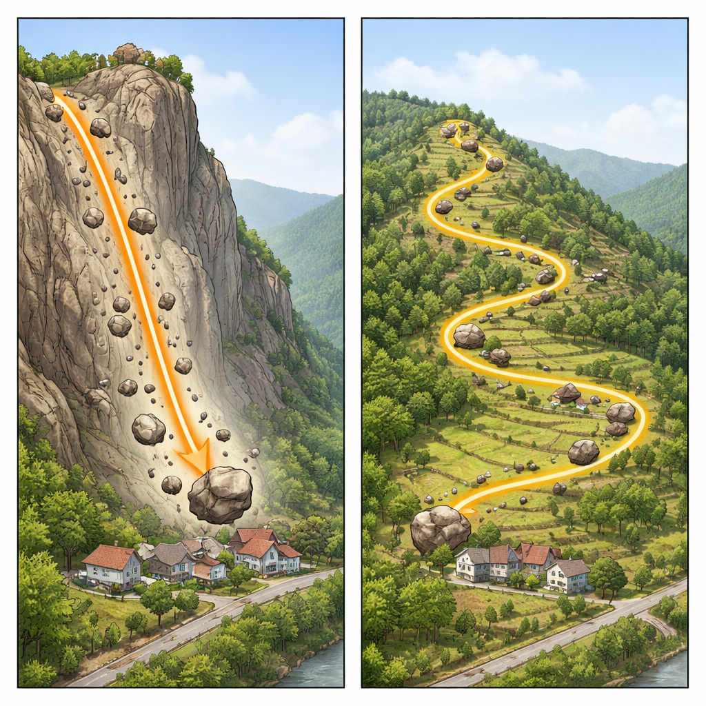
To understand what happens after a block lets go, the team built a high‑resolution 3D model of the terrain from drone imagery and ran simulations with a specialized rockfall program. They released virtual blocks from each of the six hazard zones and tracked their speed, bounce height, travel distance, and energy. The computer model reproduced observed runout distances within about 5 percent, giving confidence that its predictions are realistic. The results revealed two very different styles of motion linked to where the rocks start on the slope.
Two ways rocks can cause damage
Blocks from the upper‑middle cliff sources (WY1–WY3) travel a relatively short distance but accelerate extremely quickly, reaching speeds of more than 30 meters per second in under 15 seconds. Their kinetic energy peaks sharply, and they can bounce 15–22 meters high—enough to clear trees and low structures and slam directly into the main cluster of houses below. Calculations show that an impact from one of these large blocks could deliver forces thousands of times greater than a car crash, far beyond what ordinary masonry walls can withstand. In contrast, blocks from higher, gentler parts of the cliff (WY4–WY6) follow longer, winding paths. They lose energy as they roll, slide, and bounce across mixed terrain, but a fraction of them still arrive at more scattered homes and the village road with enough force to damage buildings and endanger people along a broad corridor.
Turning science into protection on the ground
Because the two rockfall types behave so differently, the researchers argue that a one‑size‑fits‑all approach will not work. For the short‑path, high‑energy falls that threaten the main residential area, they recommend directly reinforcing the unstable blocks with rock anchors and installing strong steel net barriers and cushioning layers between the cliff and the homes to catch fast, high‑bouncing rocks. For the longer‑runout, energy‑fading falls, they suggest a stepped system of terraces, energy‑absorbing surfaces, diversion channels, and terminal walls that slowly drain away the rocks’ momentum and steer them away from houses and roads. Together with real‑time monitoring, these measures provide a practical roadmap for reducing risk in Jiaohua Rock and offer a model for safeguarding other mountain communities living in the shadow of unstable cliffs.
Citation: Zhao, X., Fen, W., Dai, Z. et al. Dynamic rockfall risk assessment using multi-source data fusion and 3D simulation: a case study of Jiaohua rock. Sci Rep 16, 5903 (2026). https://doi.org/10.1038/s41598-026-36769-8
Keywords: rockfall, landslide hazard, mountain villages, Three Gorges, disaster mitigation