Clear Sky Science · en
Generalizing β-VDR-based derivative computation for robust source edge detection and depth estimation from potential field data
Seeing Hidden Structures Beneath Our Feet
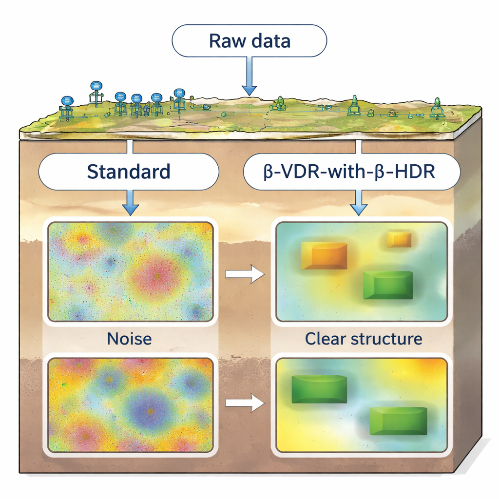
Minerals, groundwater, geothermal resources, and oil often lie deep underground, hidden from direct view. Geophysicists use subtle changes in Earth’s gravity and magnetic fields to map these buried structures without drilling. But turning those delicate measurements into clear pictures of faults, dikes, and contacts is tricky, because ordinary processing methods tend to magnify noise along with the signal. This study introduces a way to sharpen underground images while keeping the noise in check, making subsurface maps more reliable for science and exploration.
Why Edges Underground Matter
When rocks of different types or densities touch each other, they form “edges” in the subsurface—faults, contacts, and intrusions that often control where fluids, heat, and ores accumulate. Gravity and magnetic surveys can sense these boundaries indirectly as small variations, called potential field anomalies. To pinpoint the locations and depths of the sources, interpreters compute mathematical derivatives of the data, which highlight where the field changes most sharply. Unfortunately, these derivatives act like filters that boost high-frequency content, so even small amounts of random noise can overwhelm the features of interest. Existing fixes either work only when the data are very clean or require heavy computation that is hard to apply to today’s large surveys.
A Smarter Way to Take Differences
An earlier method, known as β-VDR, already offered a more stable way to compute vertical derivatives by cleverly combining versions of the data that have been upward continued—mathematically projected to higher elevations to smooth out noise. β-VDR delivers cleaner vertical derivatives than standard Fourier-based filters, but it came with two major drawbacks. First, it still relied on more fragile, finite-difference formulas for the horizontal components, leading to an imbalance: vertical derivatives were robust, horizontal ones were not. Second, the original recipe needed five separate rounds of heavy Fourier calculations, making it slow and costly for big grids.
Balancing Vertical and Sideways Views
The authors reformulated the β-VDR idea into a compact frequency-domain filter that achieves the same effect with only one forward and one inverse Fourier transform instead of five. This step alone cuts the theoretical computation time by a factor of about five. They then extended the same stabilizing logic to horizontal derivatives, creating a matched family of filters they call β-HDR. Together, the vertical β-VDR and horizontal β-HDR form a unified scheme, β-VDR-with-β-HDR, that treats all derivative directions consistently. In simple terms, the method smooths away noise just enough in every direction while preserving the sharp transitions that mark real geological boundaries.
Putting the Method to the Test
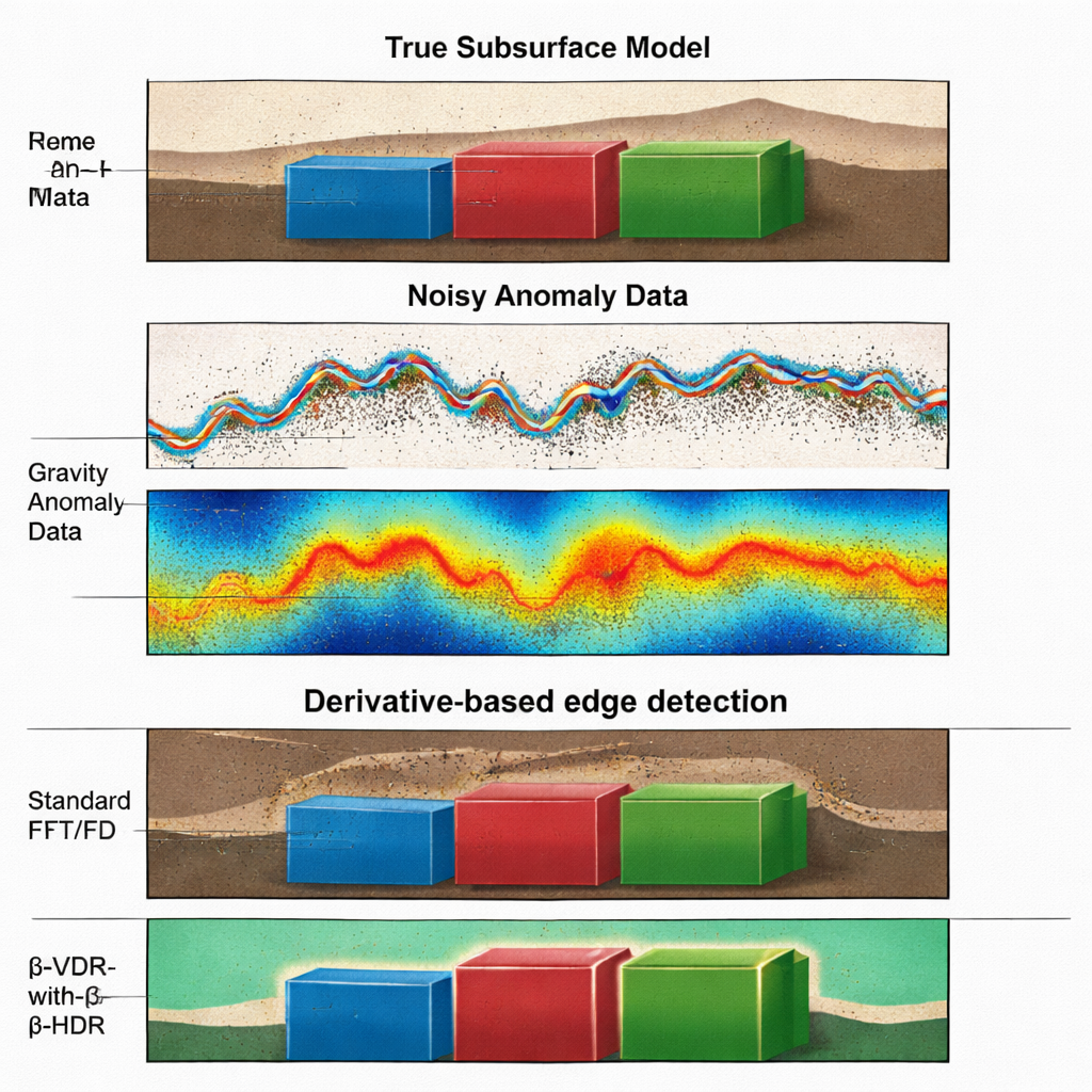
To check that the new approach is both correct and useful, the team ran extensive computer experiments. They started with synthetic models—idealized underground blocks with known shapes, depths, and physical properties—and generated their gravity and magnetic responses. By adding different levels of random noise, they recreated the kind of messy data encountered in real surveys. Using a standard edge-enhancement technique called the total gradient, which depends on both vertical and horizontal derivatives, they compared four options: traditional Fourier filters, a method called ISVD, the original β-VDR combined with conventional horizontal differences, and the new β-VDR-with-β-HDR. The new method reproduced the standard results when no stabilization was applied, confirming the mathematics. Under noisy conditions, it clearly stood out: edges remained crisp, spurious peaks were rare, and estimated depths stayed close to the true values even when other methods broke down.
From Test Models to a Real Sedimentary Basin
The authors then applied their technique to high-resolution aeromagnetic data from the Nigerian sector of the Chad Basin, a region of thick sediments where faults and intrusions influence geothermal and hydrocarbon potential. Without resorting to the usual preliminary smoothing, they computed the stabilized derivatives and total gradient, and then estimated the positions and depths of magnetic sources in both profile and full 3D views. The solutions aligned with known regional trends and revealed coherent fault-like features and intrusions, including shallow structures and deeper lineaments that may guide fluid flow. Importantly, the depth estimates from 2D profiles and 3D grids agreed closely, suggesting that the results are not artifacts of the method.
Clearer Underground Pictures for Tough Data
For a non-specialist, the takeaway is that this work offers a better “sharpening filter” for noisy gravity and magnetic maps of the subsurface. By redesigning how vertical and horizontal differences are computed, the β-VDR-with-β-HDR method extracts edges and depths of buried structures more reliably, even when measurements are contaminated by significant noise. Because it is also more efficient to compute, it can be applied to large modern datasets. This means clearer, more trustworthy images of what lies beneath our feet—supporting safer drilling decisions, improved geothermal assessments, and a deeper understanding of Earth’s hidden architecture.
Citation: Falade, S.C., Falade, A.H. Generalizing β-VDR-based derivative computation for robust source edge detection and depth estimation from potential field data. Sci Rep 16, 5672 (2026). https://doi.org/10.1038/s41598-026-36635-7
Keywords: gravity and magnetic surveys, edge detection, depth estimation, noise-robust derivatives, Chad Basin geology