Clear Sky Science · en
Quantitative risk assessment for the compound drought-wildfire disaster
When Dry Spells Feed Megafires
Across the globe, wildfires are getting bigger, faster, and more destructive. This study looks at a particularly dangerous kind of disaster: when long droughts and wildfires collide. By putting numbers on how much drought multiplies fire risk across South Korea, the researchers offer a way for governments and communities to see where and when the next megafire is most likely to strike—and how urgently they need to prepare.
Why Drought and Fire Are a Deadly Pair
Wildfires are no longer seen as isolated events. Around the world—from California to Australia and Canada—many of the worst fires have followed months or years of unusually dry weather. When drought lingers, plants lose moisture and turn into tinder; the air dries out; and even a small spark can spread quickly. The authors frame these events as compound drought–wildfire disasters: not just a fire, and not just a drought, but the dangerous interaction between the two. Yet, despite the rising toll in lives, health, nature, and money, there has been no clear way to measure this combined risk in a way that planners can use.
Turning Weather and Water Data into Risk Scores
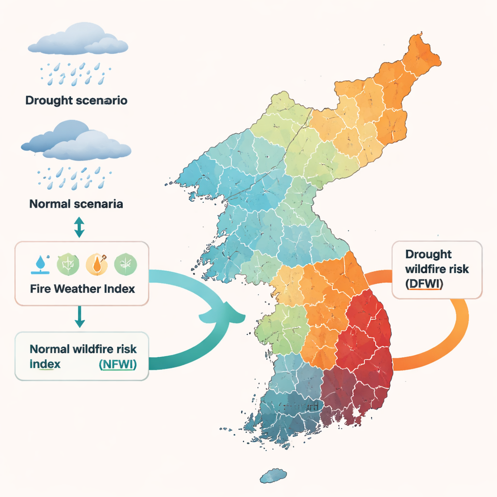
To close this gap, the study builds a step-by-step method to quantify compound drought–wildfire risk across 107 watersheds in South Korea. The team starts with decades of daily weather data—rainfall, temperature, wind, and humidity—then designs two contrasting storylines. In the “normal” storyline, each region receives its typical long-term rainfall. In the “drought” storyline, the country is hit by a severe year-long drought that statistically occurs about once every 30 years. Using advanced statistical tools, they generate thousands of realistic daily rainfall patterns for both cases, and feed them into an established fire danger tool called the Fire Weather Index, which turns weather conditions into a score for how easily fires could spread and intensify.
Measuring Fire Danger in Normal and Drought Years
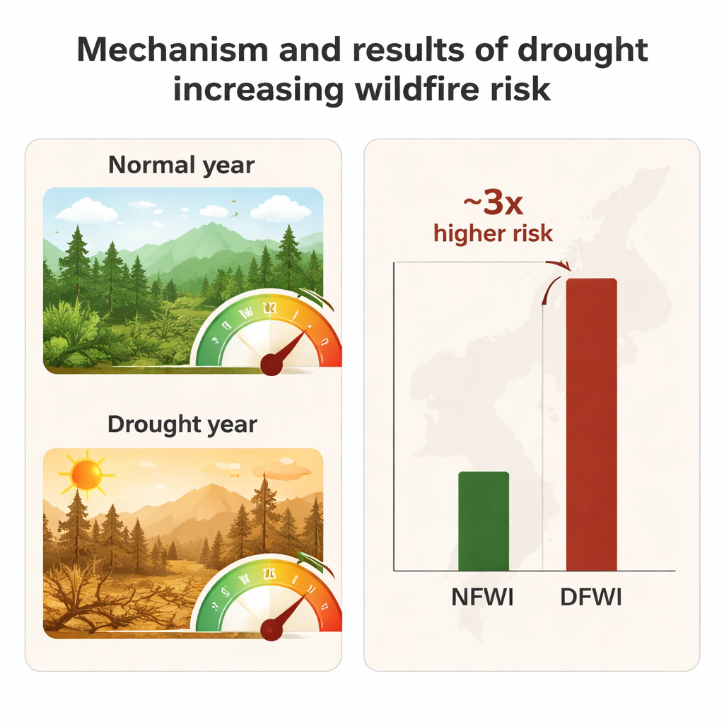
From these simulations, the authors compute two fire danger measures. The Normal Fire Weather Index (NFWI) shows wildfire risk under usual climate conditions. The Drought Fire Weather Index (DFWI) shows risk under the severe drought scenario. By comparing the two, they can cleanly isolate the added danger caused by drought alone. First, they check that the Fire Weather Index actually reflects real-world fire behavior in Korea by comparing it with historical fire counts, burned areas, and economic losses; the correlations are strong enough to treat it as a trustworthy risk indicator in this setting. Then they map average DFWI and NFWI for every watershed and every month, revealing both seasonal patterns and regional hotspots.
How Much Worse Drought Makes Wildfire Risk
The numbers are stark. On average, drought conditions make wildfire risk about three times higher than in a normal year across the peninsula. The boost is not uniform: the effect peaks in April and May, the main fire season in Korea, when dry winds, low humidity, and dead leaves already prime the landscape for ignition. In these months, drought pushes risk sharply upward. Spatially, southeastern inland basins emerge as the most vulnerable. Shielded from moist sea air by mountain ranges and governed by a dry, continental climate, these areas suffer both lower rainfall and lower humidity, creating a structural moisture deficit. The monthly risk maps show that these watersheds repeatedly fall into the highest danger categories, especially during spring and parts of autumn.
From Maps to Better Prepared Communities
To test whether their scenario-based results match real disasters, the authors compare their findings with several documented compound drought–wildfire events, including the record-breaking 2022 Gangneung–Donghae fire. In those cases, actual fire danger scores during the disasters were two to four times higher than during similar periods in non-disaster years—very close to the threefold increase predicted by the drought simulations. While the method still has limits—for example, it does not yet account for human-caused ignitions or social factors that shape actual damage—it provides a crucial numerical backbone for planning. In simple terms, the study shows that a severe year-long drought can transform already risky landscapes into extreme fire zones, and pinpoints when and where this transformation is most likely. That kind of quantified insight can help governments prioritize high-risk regions, time their preparedness efforts, and move from reacting to wildfires toward truly anticipating them.
Citation: Kim, K., Kim, H.S. Quantitative risk assessment for the compound drought-wildfire disaster. Sci Rep 16, 7034 (2026). https://doi.org/10.1038/s41598-026-36589-w
Keywords: wildfire risk, drought, climate change, disaster planning, South Korea