Clear Sky Science · en
A UAV RGB dataset and method for instance tree crown segmentation for biodiversity monitoring
Why counting trees from the sky matters
Healthy forests quietly regulate our climate, store carbon, and shelter countless species. Yet tracking how individual trees grow, die, or suffer from disease over large areas is incredibly hard with people on the ground alone. This study shows how off-the-shelf camera drones and clever image analysis can automatically outline single tree crowns in dense tropical forests. That ability is a key step toward detailed, affordable biodiversity monitoring and better forest management in a warming world.
Seeing individual trees in a sea of green
From above, a mature forest often looks like an unbroken carpet of leaves. In reality, it is made up of many overlapping tree crowns of different species and sizes. To understand forest health or carbon storage, scientists need to know where one tree ends and the next begins. This task, called instance tree crown segmentation, is especially difficult in dense tropical forests, where neighboring crowns blend into each other and shadows, seasonality, and similar shapes confuse both humans and algorithms. Traditional methods either miss trees, merge several trees into one, or require expensive sensors such as lasers. The authors instead focus on doing more with simple color photos taken from drones, which are far cheaper and easier to deploy around the world.
A new picture library of tropical forests
To teach and test their algorithms, the researchers created a new image collection called ForestSeg. Using two commercially available drones over a biodiversity-rich forest near Hanoi, Vietnam, they flew four campaigns at different heights and in different months. From these flights they built high-resolution overhead images and then cut them into small square patches, each 1024 by 1024 pixels, that typically contain 6 to 10 trees. Human experts carefully traced the outline of each visible crown, creating a total of 2,944 annotated patches across four subsets. Because the flights span seasons and altitudes, ForestSeg captures changes in lighting, leaf color, and apparent tree size, making it a demanding testbed for any method that claims to work reliably over time.
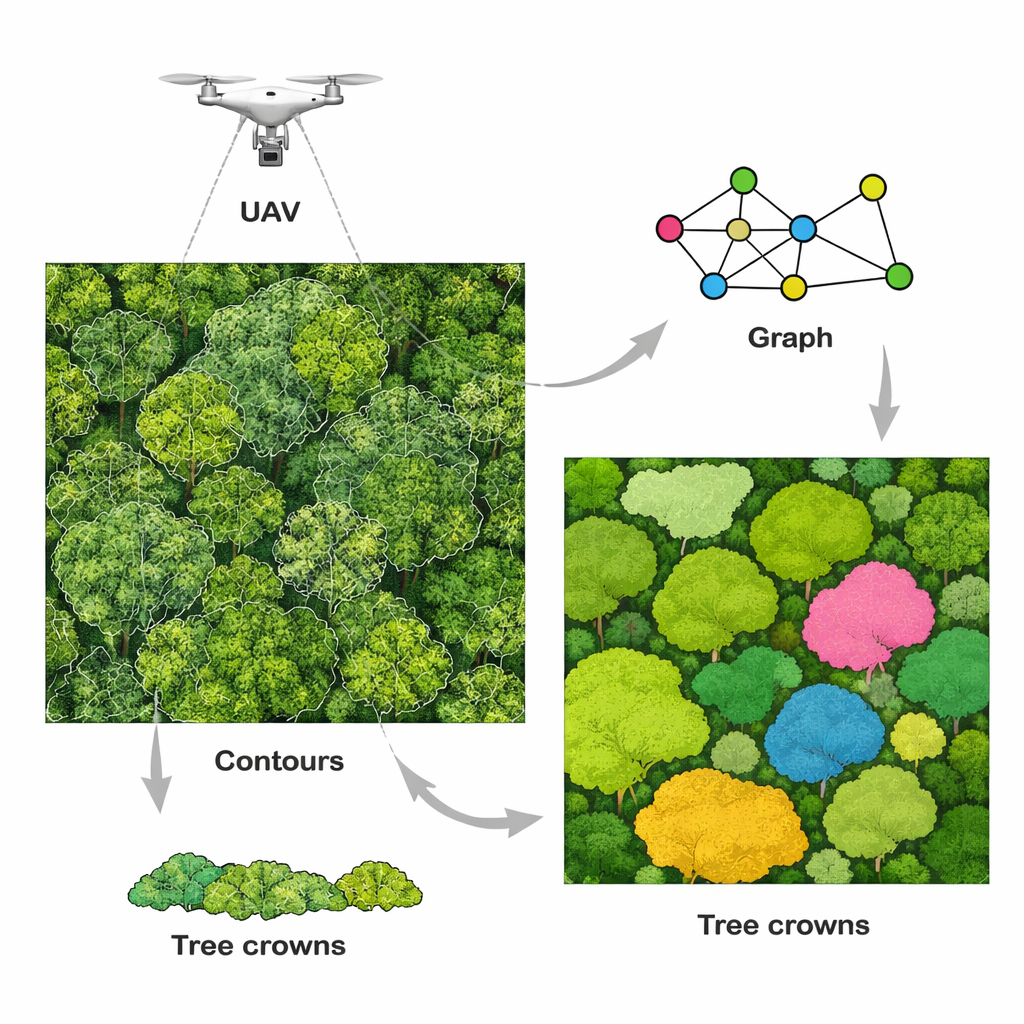
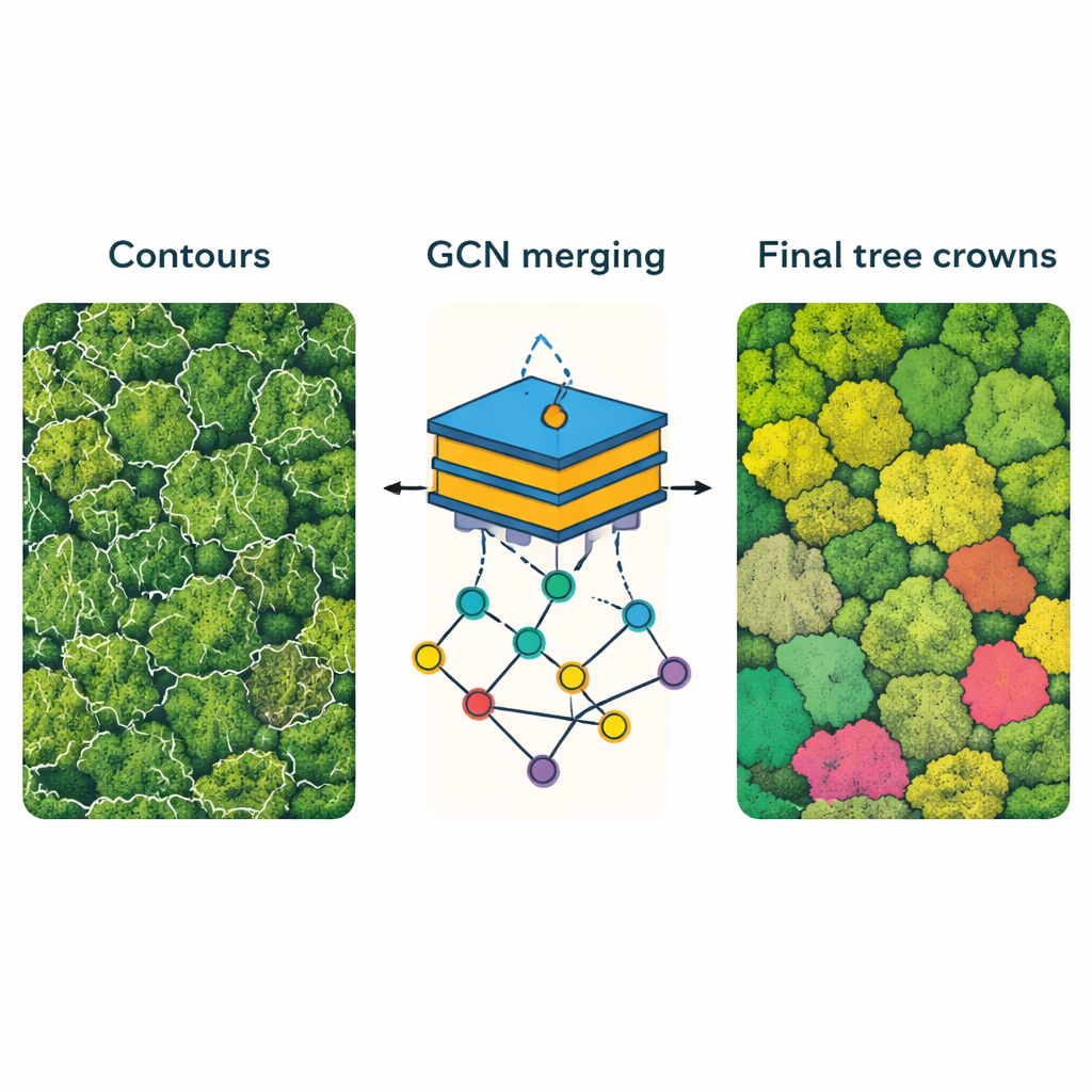
Breaking trees into pieces to find whole crowns
Rather than trying to draw tree outlines in one shot, the team designed a two-step strategy called TreeCoG. First, they deliberately “over-segment” the canopy. A modern edge-detection network marks fine boundaries in the drone image, carving the forest into many small contour pieces that are unlikely to contain parts of several trees at once. Second, these pieces are turned into nodes in a graph, where nearby fragments are connected and compared. For each fragment, the method measures simple shape properties such as area and elongation, and also analyzes how similar two neighboring patches look in color and texture. A graph neural network then learns, from many labeled examples, which neighboring fragments belong to the same tree and should be merged, and which belong to different trees and must stay separate. The result is a set of masks that outline individual crowns more cleanly than earlier approaches.
How well the method works in practice
To judge performance, the authors compared TreeCoG against popular deep-learning tools for object segmentation, including Mask R-CNN and the latest YOLO models. On ForestSeg, TreeCoG achieved the highest accuracy while also running faster than its competitors, making it attractive for large-area surveys. It also performed strongly on an independent European benchmark dataset known as BAMFORESTS, showing that the approach can transfer to forests in other regions. By analyzing results across the four ForestSeg subsets, the study further reveals how time of day, season, and flight altitude influence success: sharper images and lower sun angles tend to give clearer crown boundaries, but the method remains robust even when conditions are less than ideal.
What this means for forests and biodiversity
In simple terms, this work shows that inexpensive drones and smart algorithms can reliably pick out individual trees in some of the most complex forests on Earth. The ForestSeg dataset gives researchers a demanding new benchmark, and TreeCoG offers a practical recipe for turning raw aerial photos into detailed maps of tree crowns. Those maps can feed into later steps such as species recognition, growth tracking, and health assessment, ultimately helping scientists and forest managers monitor biodiversity and carbon stocks more frequently and over larger areas than has been possible with field surveys alone.
Citation: Do, M.V.H., Phung, DT., Pham, H.D.L. et al. A UAV RGB dataset and method for instance tree crown segmentation for biodiversity monitoring. Sci Rep 16, 5788 (2026). https://doi.org/10.1038/s41598-026-36541-y
Keywords: drone forestry, tree crown mapping, biodiversity monitoring, remote sensing, deep learning segmentation