Clear Sky Science · en
Quantifying roadless areas and fragmentation in the context of wildlife-vehicle collision risk in Great Britain
Why quiet spaces between roads matter
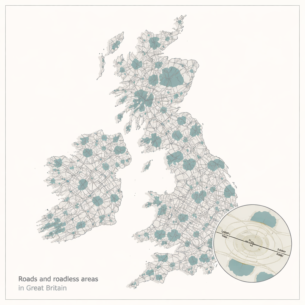
Across Great Britain, it’s hard to get far from a road. Yet the remaining pockets of land that lie beyond the reach of traffic noise, fumes and headlights can be crucial refuges for wildlife. This study asks a deceptively simple question: where are those road‑free patches, how big are they, and are they doing enough to protect animals from being killed on our roads?
Islands in a sea of tarmac
Using detailed digital maps of Britain’s road network, the researchers drew “road effect zones” extending 100, 500 and 1,000 metres out from every paved road. Any land beyond those zones counted as a “roadless area” – an island of relative quiet in a sea of infrastructure. They found that, depending on how far road impacts are assumed to reach, between about one‑fifth and three‑quarters of Britain’s land can be classified as roadless. But this apparent abundance is deceptive: at the commonly used 1‑kilometre distance, there were just over 6,000 roadless patches and more than 70% of them were smaller than one square kilometre.
Different countries, different patterns
The picture also varies sharply between England, Scotland and Wales. Scotland, with its mountains and sparse population, held the largest and least fragmented roadless areas, especially in the Highlands and Cairngorms. England had by far the most individual patches but they were much smaller on average and covered the lowest share of land, reflecting its dense web of roads and people. Wales sat in between. A fragmentation measure that captures how likely two random points fall in the same unbroken patch confirmed this contrast: landscapes in Scotland are far less chopped up by roads than those in England, with Wales again in the middle.
What lives in the gaps?
To understand what these roadless areas actually look like on the ground, the team overlaid national land‑cover maps. The most common habitats were open, largely human‑managed ones: acid grassland, heather, bogs and conifer plantations, rather than the improved grasslands and suburban areas that dominate much of Britain. They then combined this with a national “ecological status” map, which reflects how many species from several major groups are present in each area. Surprisingly, larger roadless patches often had slightly lower ecological scores, likely because many are heavily grazed uplands. However, patches that overlapped official protected areas tended to have somewhat higher ecological status, suggesting that protection does help. Overall, nearly half of all roadless land already lies within some kind of protected area, but many patches are only partially covered, leaving large tracts of unprotected land that might still be valuable for nature.
Wildlife on the move – and at risk
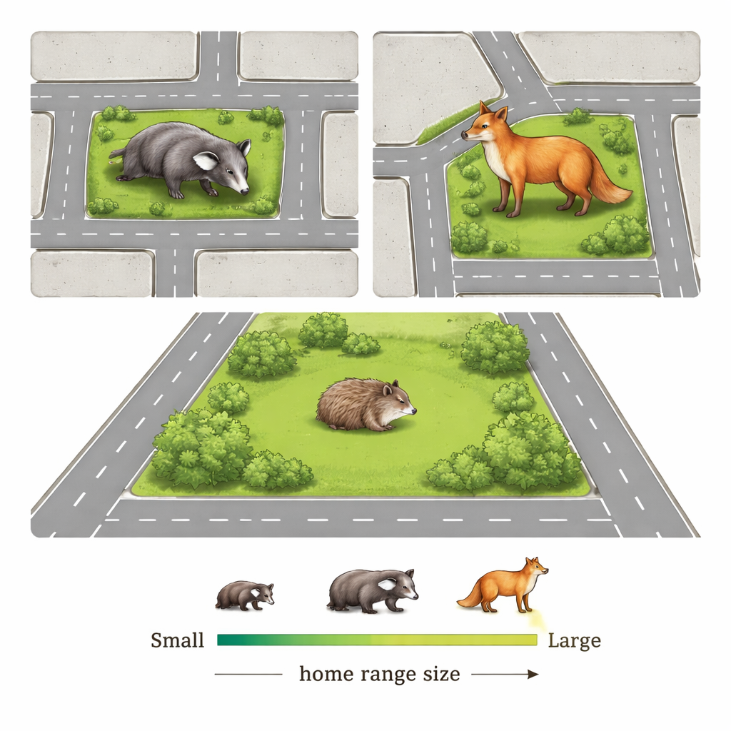
Roads do not just cut up habitats; they also create deadly barriers for animals that need to roam. The researchers compared the size of roadless patches with typical home ranges for ten mammal species often found as roadkill in Britain, including badgers, foxes, hedgehogs and rabbits. For animals with larger territories, such as badgers and roe deer, fewer than half of the available roadless patches were big enough to hold a typical home range. That means many individuals must regularly cross roads to find food, mates or shelter, raising their risk of being hit by vehicles. Species with smaller home ranges, like grey squirrels and hedgehogs, had many more suitably sized patches, but they too still encounter roads frequently, especially when their movements follow long, narrow features like rivers or hedgerows that intersect traffic corridors.
Using roadless land to reconnect nature
The authors argue that roadless areas could be powerful tools for conservation in a country where truly wild spaces are scarce. About 27% of Britain’s land already carries a formal conservation label, yet many existing protected sites are small, fragmented and not always well managed. If all currently unprotected roadless patches were brought into protected networks, the total protected area would rise above international “30 by 30” targets, at least on paper. More realistically, they suggest prioritising bigger patches and using them as anchors, then improving links between smaller patches with wildlife crossings, restored habitats or changes in local land use. Because roadless land can also store carbon, regulate water and offer space for recreation, protecting it could benefit both wildlife and people.
What this means for everyday life
For the lay reader, this work highlights that road safety is not only about human drivers and passengers; it is also about the wildlife forced to navigate our transport network. Britain’s countryside is much more fragmented than it might appear from a scenic lay‑by. Many animals simply cannot meet their basic needs without venturing onto roads, which helps explain the high numbers of wildlife‑vehicle collisions. By mapping where quiet spaces still exist, and showing how they overlap with conservation areas and animal movements, this study provides a practical starting point for making transport planning and nature recovery work together – aiming for a future where both people and wildlife can travel more safely across the landscape.
Citation: Raymond, S., Chadwick, E.A. & Perkins, S.E. Quantifying roadless areas and fragmentation in the context of wildlife-vehicle collision risk in Great Britain. Sci Rep 16, 3890 (2026). https://doi.org/10.1038/s41598-026-36410-8
Keywords: roadless areas, habitat fragmentation, wildlife vehicle collisions, conservation planning, Great Britain