Clear Sky Science · en
Spatiotemporal heterogeneity-aware meta-parameter interaction learning for traffic flow forecasting
Why smarter traffic forecasts matter
Anyone who has been stuck in a surprise traffic jam knows that roads do not behave in a simple, predictable way. Congestion can change from block to block and minute to minute, and even the same road can look very different on a weekday morning compared with a holiday night. This study introduces a new artificial intelligence framework, called SHAMPIL, that is designed to understand these shifting patterns more precisely, helping future traffic apps, city planners, and even autonomous vehicles make better decisions in real time.
Different roads, different rhythms
Traditional traffic models often assume that all parts of a road network follow similar patterns over time. In reality, each sensor or road segment has its own rhythm. One highway ramp may see sharp rush-hour spikes, while a nearby suburban segment flows smoothly with gentle peaks at different times. The authors call this variation across space and time “spatiotemporal heterogeneity.” Using real data from California’s highway sensor system, they show how two nearby sensors can record very different traffic curves, with distinct average volumes, volatility, and peak hours. Ignoring these differences leads to forecasts that are too coarse to capture local surges or dips that drivers actually experience. 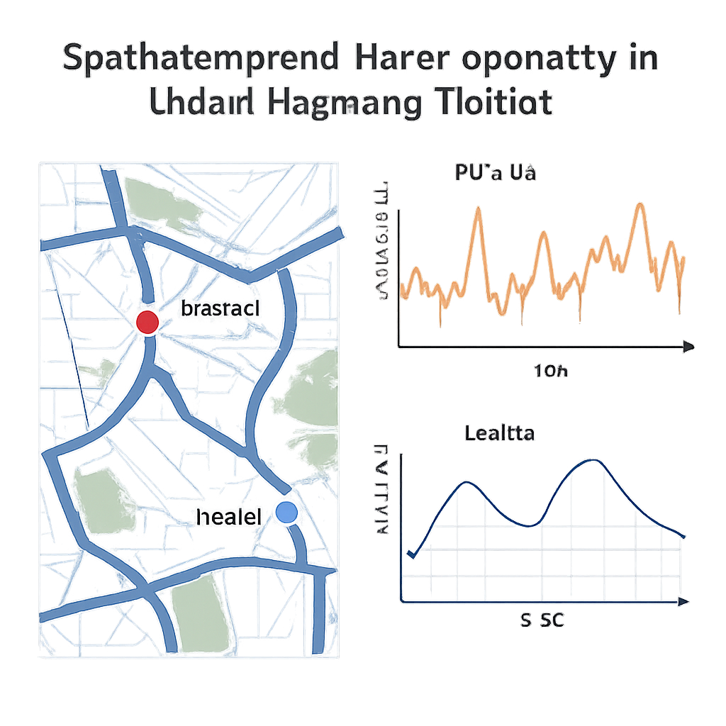
Teaching the model to recognize context
SHAMPIL tackles this problem by first teaching the model to recognize context without relying on external information like maps or land-use labels. It learns a “time fingerprint” that encodes when in the day and which day of the week a prediction is being made, capturing regular cycles such as morning and evening rush hours or weekend slowdowns. At the same time, it learns a “place fingerprint” for each sensor in the network, reflecting how that location usually behaves compared with others. These learned fingerprints allow the system to silently cluster similar times and places together and to distinguish, for example, a busy downtown junction from a quiet outer ring road, even if they sit only a short distance apart.
Adapting its own inner rules on the fly
Most forecasting systems use a single fixed set of internal parameters for all locations and times. SHAMPIL instead maintains a compact pool of reusable parameter patterns and uses the learned time and place fingerprints to mix them differently for each situation. In effect, the model is not just learning traffic patterns; it is also learning how to reconfigure itself for Monday mornings versus Sunday nights, or for congested hubs versus stable stretches. This meta-parameter mechanism gives SHAMPIL the flexibility of having many specialized models while keeping the memory and computation costs manageable enough for large road networks.
Following traffic as a living network
Traffic does not move in isolation: a backup on one highway can ripple through ramps and nearby streets. To reflect this, SHAMPIL includes an interaction module that treats the road system as a living network whose connections can change over time. It alternates between looking along the time axis, using convolutions to capture short- and long-term trends, and looking across space, using a dynamic graph that links sensors whose behavior appears related at that moment. A learned “traffic pattern library” helps this graph focus on enduring relationships, while another component captures instant, short-term similarities. By repeatedly letting time-focused and space-focused views inform each other, SHAMPIL builds a richer picture of how congestion grows, travels, and fades across the network. 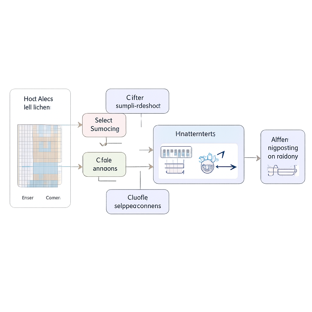
What the tests show on real highways
The researchers evaluated SHAMPIL on four benchmark highway datasets from California, each containing months of measurements from hundreds of sensors sampled every five minutes. They compared their method against nearly 30 established techniques, from classic statistical tools to the latest graph-based deep learning models. Across all datasets and all forecast horizons up to one hour ahead, SHAMPIL consistently produced the lowest errors. It was especially strong on more complex networks, where traffic conditions vary sharply across space and time. Visual comparisons show that its predicted curves closely follow real traffic, even during volatile rush-hour peaks, and statistical analyses reveal not only higher accuracy but also more stable performance with fewer extreme mistakes.
What this means for everyday travel
In simple terms, SHAMPIL shows that traffic forecasts can be improved by acknowledging that every place and every moment is different—and by letting the forecasting system reorganize itself around those differences. By combining context-aware internal tuning with a dynamic view of how roads influence one another, the method delivers more accurate, robust predictions on real-world highway data. As such techniques are refined and deployed, they could power navigation tools that better anticipate sudden slowdowns, support smarter traffic signal control, and help city planners design road networks that respond more gracefully to daily life and unexpected events.
Citation: Liu, C., Xue, X., Wang, S. et al. Spatiotemporal heterogeneity-aware meta-parameter interaction learning for traffic flow forecasting. Sci Rep 16, 6997 (2026). https://doi.org/10.1038/s41598-026-36350-3
Keywords: traffic forecasting, graph neural networks, spatiotemporal patterns, intelligent transportation, deep learning