Clear Sky Science · en
Integration of β-VAE, DWT, and GMM for Sentinel-2-based mapping of hydrothermal alteration and iron speciation in the Zafarghand area, Iran
Why Finding Hidden Metals from Space Matters
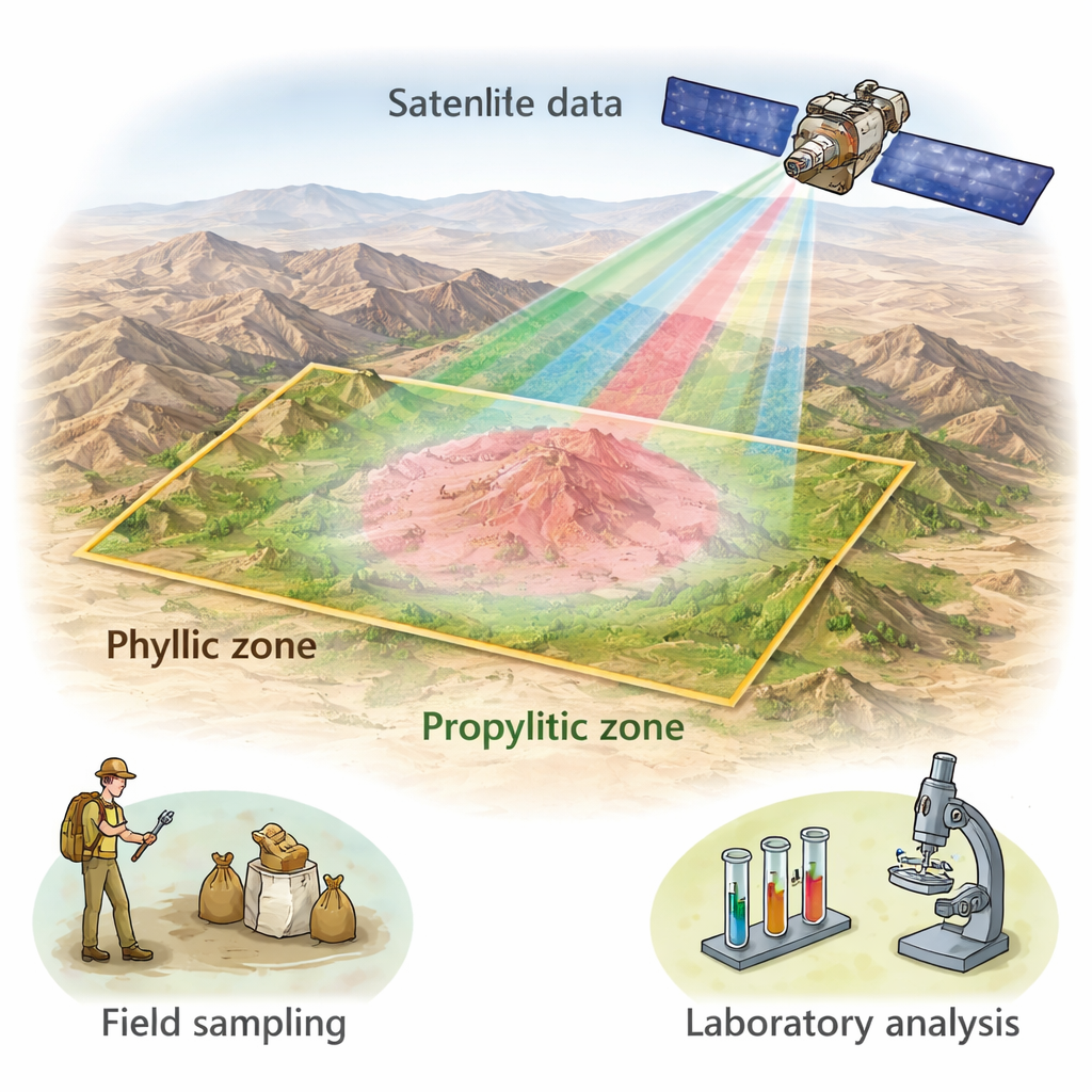
As easy-to-reach metal deposits are mined out, exploration companies must search in ever more remote and rugged terrain. This study shows how scientists can use a European Earth‑observing satellite, combined with modern artificial intelligence, to spot subtle chemical changes in rocks—called alteration zones—that often surround copper and gold deposits. By detecting these clues from space over central Iran, the researchers demonstrate a faster, cheaper, and less invasive way to guide on‑the‑ground mineral exploration.
A Rocky Target in Central Iran
The work focuses on the Zafarghand area, part of a major volcanic belt in central Iran that hosts copper‑bearing “porphyry” systems. In these systems, hot fluids once rose from cooling magma, altering the surrounding rocks in a series of halos. Closer to the intruding rock body, phyllic alteration forms, rich in quartz and fine white mica and commonly tied to copper and gold. Farther out, propylitic alteration develops, marked by greenish minerals such as chlorite and epidote that outline the outer edge of the hydrothermal system. Iron is also reshuffled, producing minerals that contain iron in different chemical states, all of which leave distinct color and brightness patterns in satellite images.
Seeing Invisible Patterns in Satellite Light
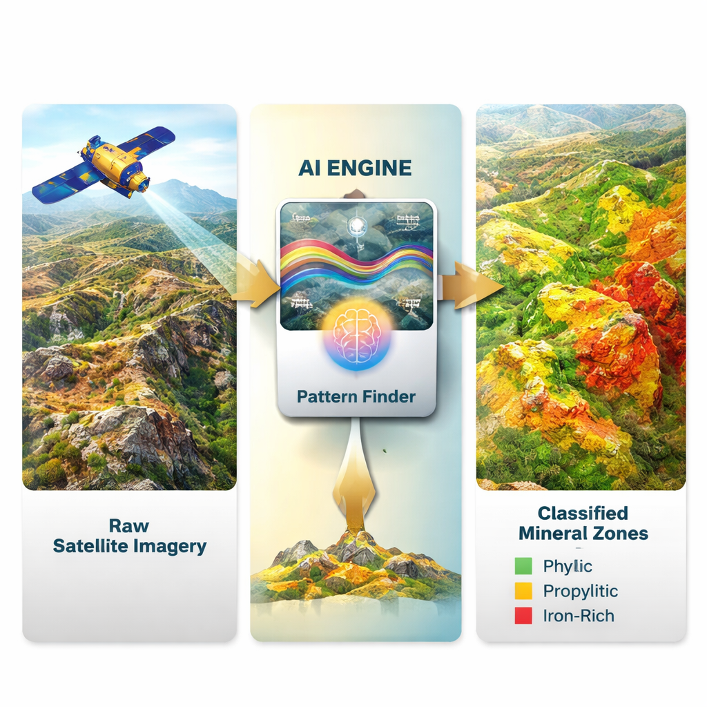
To tap into these clues, the team used data from the Sentinel‑2 satellite, which records reflected sunlight in several visible and infrared bands at 20‑meter resolution—fine enough to map large alteration halos. Instead of relying on hand‑crafted color combinations or simple band ratios alone, they built an entirely unsupervised workflow. First, they fed six carefully chosen Sentinel‑2 bands into a deep‑learning model known as a beta‑variational autoencoder. In non‑technical terms, this “pattern compressor” learns to represent each pixel by a small set of numbers that capture its most important spectral traits without needing any pre‑labeled training data. These compressed features emphasize subtle differences between altered and unaltered rocks that the raw bands may hide.
Adding Texture and Probabilities
The next step was to inject a sense of spatial texture—how pixels relate to their neighbors—because alteration zones are organized over hundreds of meters, not pixel by pixel. For this, the authors used a mathematical tool called the discrete wavelet transform, which separates each latent feature map into large‑scale background and finer details. They focused on the low‑frequency components that highlight broad, coherent patterns in the landscape. Finally, they clustered these enriched features with a Gaussian mixture model, a statistical method that groups pixels into classes while allowing for uncertainty along fuzzy boundaries. This sequence—compression, multiscale smoothing, then probabilistic clustering—yields separate maps of phyllic, propylitic, and iron‑rich zones without ever telling the algorithm where those zones are.
Checking Against Rocks, Chemistry, and Simple Ratios
Because remote sensing alone can mislead, the team validated their maps against field and laboratory data from 251 soil and rock samples. Independent geological and petrographic work had already identified which samples lay in phyllic or propylitic zones. When these points were overlaid on the satellite‑derived map, about 95% of both phyllic and propylitic samples fell into the model’s corresponding zones. A stricter, pixel‑by‑pixel test using small buffers around each sample still yielded overall accuracies of about 94.5% for phyllic and 86.9% for propylitic alteration. For iron, where field data were lacking, the authors compared their results to standard Sentinel‑2 band ratios that highlight ferric and ferrous iron. Agreement was again high, with overall accuracies near or above 97% for the different iron species.
What This Means for Future Exploration
In plain terms, the study shows that a smart combination of satellite imagery and AI can reliably outline the key alteration halos and iron patterns around a porphyry copper system, even without labeled training data. While smaller and deeper zones—such as potassic or silicic alteration—remain harder to see at Sentinel‑2’s resolution, the method robustly captures the broad phyllic and propylitic belts that matter most for early‑stage targeting. Because the approach is data‑driven, inexpensive, and transferable, it can be applied to other prospective regions worldwide, helping explorers focus costly fieldwork on the most promising ground.
Citation: Kalkhoran, S.E., Ghannadpour, S.S. Integration of β-VAE, DWT, and GMM for Sentinel-2-based mapping of hydrothermal alteration and iron speciation in the Zafarghand area, Iran. Sci Rep 16, 6470 (2026). https://doi.org/10.1038/s41598-026-36349-w
Keywords: remote sensing, porphyry copper, hydrothermal alteration, Sentinel-2, deep learning